Area Overview for S65 2YP
Photos of S65 2YP


Area Information
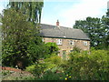
Living in S65 2YP offers a settled residential experience within a small cluster of homes covering a population of 1,461. This postcode represents a specific, contained community where daily life revolves around established neighbourhood ties. The area is defined by its compact scale, which fosters a close-knit environment typical of smaller residential pockets in England. Residents navigate familiar streets and benefit from the convenience of proximity to larger urban hubs through designated transport links. The character of S65 2YP is shaped by its demographic reality, with the majority of the local population falling into the 30 to 64-year-old bracket. This age profile suggests a community of adults who have likely put down roots rather than seeking transient living arrangements. With over half of the households owning their properties, the area feels stable and established. Prospective buyers looking for a quiet spot away from high-density urban centres will find S65 2YP fits their criteria for a contained home environment. The lack of industrial zoning or protected nature reserves within the immediate vicinity further confirms its focus on residential utility.
- Area Type
- Postcode
- Area Size
- Not available
- Population
- 1461
- Population Density
- 6419 people/km²
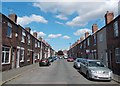
The property market in S65 2YP is characterised predominantly by owner-occupied housing, with 51% of households holding the title deeds to their dwellings. This high level of home ownership points to a market where residents view their homes as long-term assets rather than temporary rentals. The accommodation type is exclusively houses, offering a distinct alternative to flat-based living found in more urban sections of the region. Buyers looking at S65 2YP should expect a stock of detached or semi-detached properties typical of established residential clusters. The composition of just houses means that there are no blocks of flats or purpose-built rental schemes within the immediate postcode boundary. This exclusivity to houses often attracts families and older singles who value outdoor space and privacy. Given the total population of only 1,461, the supply of homes is naturally limited, which can make finding specific property types require patience. Collins Street or similar local roads in the immediate vicinity likely host these familia-oriented homes. The area does not contain any protected woodland or nature reserves that would restrict development or land use, meaning the housing footprint remains purely residential. For those considering a move, the 51% ownership rate signals a stable community where change happens gradually rather than through large-scale regeneration projects. The lack of rental data suggests that buying is the primary entry mechanism for new residents.
House Prices in S65 2YP
No properties found in this postcode.
Energy Efficiency in S65 2YP
Residents of S65 2YP benefit from immediate access to essential retail and leisure amenities within practically reachable distances. Five retail outlets are located nearby, providing convenience for daily shopping needs. Notable stores include Heron East, Farmfoods Rotherham, and Iceland Sycamore, ensuring that groceries and household goods are easily attainable without long commutes. Transport infrastructure supports an active lifestyle with five accessible metro stations and five railway stations in the immediate vicinity. Key transport hubs include Rotherham Central Railway Station and Meadowhall Railway Station, which facilitate easy travel to Leeds, Sheffield, and other major cities. The presence of five metro stops, notably Parkgate and Meadowhall South, adds further flexibility for local journeys. The combination of full-strength retail options and robust rail connectivity defines the daily rhythm of life here. Shoppers can visit Iceland Sycamore for morning provisions or use Farmfoods Rotherham for larger household purchases. Commuters rely on the five nearby rail stations to reach workplaces across the north of England. This blend of local convenience and wide-reaching transport options means S65 2YP remains connected despite its small, residential nature. The area does not suffer from isolation, as these five retail and five transport nodes provide a comprehensive support network for local living.
Amenities
Schools
| Rank | School | Type | Entry gender | Ages |
|---|
Explore more schools in this area
Go to Schools tabDemographics
The community in S65 2YP reflects the needs of adults, as the most common age range spans from 30 to 64 years. This demographic concentration indicates a neighbourhood populated by working families, empty nesters, and those in mid-career stages of life. With a median age of 47, the area attracts older populations compared to many youthful city centres. This stability supports long-term investment and consistent local community engagement. Property ownership stands at 51%, placing the area slightly above the national average for home ownership. This majority of owner-occupiers creates a resident base motivated by stability and school catchment areas. The accommodation type is exclusively houses, distinguishing S65 2YP from areas dominated by flats or terraced units. This housing stock appeals to families seeking garden space and independent living arrangements. Census data indicates that the predominant ethnic group is White, aligning with the broader demographic trends of the surrounding region. There is no specific data on deprivation levels or income distribution available for this specific postcode, so quality of life assessments rely on the strong foundation of home ownership and age stability. The area does not rely on social housing, suggesting a market-driven economy for local residents. The population count of 1,461 keeps the neighbourhood manageable, ensuring that local services remain accessible without the isolation of very small, sparse villages.
Household Size
Accommodation Type
Tenure
Ethnic Group
Religion
Household Composition
Age
Household Deprivation
NS-SEC
Explore more demographic insights in this area
Go to Demographics tabPlanning
Planning Constraints
- Flood RiskPremium
- Ramsar Wetland SitesPremium
- Area of Outstanding Natural BeautyPremium
- Protected Nature ReservePremium
- Protected WoodlandPremium