Area Overview for S65 1AU
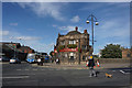
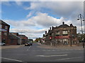
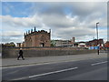
Photos of S65 1AU


Area Information
Living in S65 1AU means residing in a small, tightly defined residential cluster covering just 609 square metres in England. With a population of 2,249 residents, you will find a high population density of 1,483 people per square kilometre. This specific postcode area functions as a concentrated community rather than a sprawling neighbourhood. Your daily life is defined by proximity to essential services and a distinct lack of open green spaces within the immediate boundaries. The environment is urban and utilitarian, focused on efficient access to transport links and local shops. You trade the quiet of a countryside village for the convenience of being close to major rail stations and retail hubs. This compact size suggests that most activity happens within a short walk or a brief drive. There are no protected nature reserves or areas of outstanding natural beauty to offer expansive views or recreational walking trails locally. Instead, your landscape is shaped by the practicality of urban living in the Rotherham district. You experience a community where neighbours might know one another due to the higher density, yet the physical space remains limited. Properties here are situated in a setting that prioritises accessibility over seclusion.
- Area Type
- Postcode
- Area Size
- 609 m²
- Population
- 2249
- Population Density
- 1483 people/km²
The property market in S65 1AU is characterised by a predominance of rental accommodation rather than owner-occupied homes. With only 19% of homes in this postcode area belonging to owners, you will find a market heavily weighted towards tenants. The accommodation type is defined by flats, which is a crucial detail for anyone seeking specific architectural styles or viewing layouts. This concentration of flats typically reflects high-density urban living where land value restricts single-family homes. Buyers looking for a permanent family house with a garden may find S65 1AU unsuitable based on the current housing stock data. The low ownership rate indicates that the supply side consists mainly of investment properties or council stock. When searching for homes in S65 1AU, you must be prepared for a landscape of multi-unit buildings rather than detached properties. This market structure often means higher demand for rentals and potentially competitive bidding for the few flats available for purchase. The specific nature of the housing stock means that insulation, shared walls, and balcony access become more important considerations than private garden space. Understanding this distinction helps you navigate the listings accurately.
House Prices in S65 1AU
No properties found in this postcode.
Energy Efficiency in S65 1AU
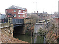
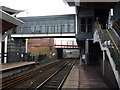
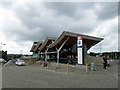
Your daily lifestyle in S65 1AU revolves around practical access to retail and transport hubs within a short radius. Retail options include Heron Rotherham, Morrisons Daily, and Tesco Rotherham, providing you with groceries and essential household goods without needing a long drive. These three notable stores ensure that your shopping needs are met by multiple retailers nearby. Transport connectivity is exceptional, with five metro stations and five rail stations located within practical reach. Key transport nodes include Rotherham Platform Both Directions, Parkgate, Meadowhall South, Rotherham Central Railway Station, and Meadowhall Railway Station. This density of stations makes commuting to other parts of England swift and convenient. You can choose from various services depending on your destination or time of day. The proximity to Meadowhall suggests access to larger shopping complexes and leisure facilities beyond the high street. This concentration of amenities creates a self-sufficient environment where you spend less time travelling and more time in the area or at work. The ease of access to both local shops and major national stations defines the character of your daily routine.
Amenities
Schools
For families living in S65 1AU, the nearest educational provision includes the RNN Group, which operates as a sixth-form college. This institution caters to students aged 16 to 19 or those pursuing higher education qualifications. The absence of primary or secondary schools listed in the immediate data suggests that younger children would need to attend institutions further away from this specific postcode cluster. The presence of a sixth-form facility implies that the area serves as a residential hub for older students or commuters attending local further education. Families with young children may find the local school catchment areas dictate their choice of property rather than proximity to playgroups or nurseries. The RNN Group provides an option for post-compulsory education without students needing to travel long distances to other boroughs. However, the limited school data means you cannot confirm the distance to the nearest infant or junior school from this location. You must research the nearest primary schools outside of the immediate postcode boundary. The availability of a sixth-form college suggests that the local infrastructure supports educational continuity for teenagers, even if primary education resources are located elsewhere in the wider borough.
| Rank | School | Type | Entry gender | Ages |
|---|
Explore more schools in this area
Go to Schools tabDemographics
The community structure in S65 1AU is dominated by adults, with the most common age range falling between 30 and 64 years old. The median age for residents is 47, which indicates a mature living environment. You should expect to interact primarily with working-age individuals, families raising older children, or people approaching retirement. Home ownership stands at 19%, a figure that is notably low compared to the national average. This statistic suggests that the vast majority of residents rent their properties rather than owning them outright. The dominant accommodation type consists of flats, aligning with the high density of the postcodes. This housing style reflects the urban nature of the area and the need for vertical living solutions. Ethnically, the predominant group is White, forming the core demographic of this specific cluster. The combination of a mature age profile, low ownership rates, and flat-based accommodation creates a specific household dynamic. Tenants make up the overwhelming majority of the population, likely commuting to employment in nearby industrial or office districts. This demographic profile points to a diverse stream of income and lifestyles, driven by renting rather than long-term family accumulation. The concentration of adults also means that the area may lack the large number of primary school-aged children found in family-heavy districts.
Household Size
Accommodation Type
Tenure
Ethnic Group
Religion
Household Composition
Age
Household Deprivation
NS-SEC
Explore more demographic insights in this area
Go to Demographics tabPlanning
Planning Constraints
- Flood RiskPremium
- Ramsar Wetland SitesPremium
- Area of Outstanding Natural BeautyPremium
- Protected Nature ReservePremium
- Protected WoodlandPremium