Area Overview for S61 2NB
Photos of S61 2NB


Area Information
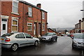
Living in the S61 2NB postcode cluster offers a specific residential experience characterised by its small, contained population. This area houses approximately 1,559 residents across a compact footprint, resulting in a high density of roughly 1,556 people per square kilometre. You will find this postcode acts as a tight-knit residential pocket rather than a sprawling suburb. The close proximity of neighbours defines daily life here, creating a locality where residents are likely familiar with the activities occurring just around the corner. While the area does not boast extensive land coverage, its density ensures that essential services and transport links remain within a short travel radius. The demographic structure suggests a mature community, with a resident base that skews significantly towards middle age. This concentration of older residents influences the character of the neighbourhood, favouring quiet streets and established housing patterns over the noise of high-density urban zones. You approach this postcode knowing it is a defined residential zone with clear boundaries, making it easy to navigate local routes and understand the community dynamics without the confusion of a large, amorphous district.
- Area Type
- Postcode
- Area Size
- Not available
- Population
- 1559
- Population Density
- 1556 people/km²
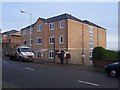
The housing market in S61 2NB presents a landscape dominated by houses, distinguishing it from areas where flats or apartments form the primary stock. With a home ownership rate of 37%, you will encounter a mixed market where one-third of the local population owns their property outright or via mortgage, while the remaining residents rent. This split suggests the area appeals to both owner-occupiers seeking space and houses suited to single families or adults, as well as renters looking for established homes within the postcode boundaries. The absence of flats in the recorded data points towards a residential character focused on larger, likely detached or semi-detached properties rather than high-density living blocks. When searching for homes in S61 2NB, you can expect to prioritise standalone dwellings, which often command higher value due to their size and privacy. The limited population of 1,559 means the total number of properties is restricted compared to larger towns, potentially leading to a competitive environment for the specific house types available in this small cluster.
House Prices in S61 2NB
No properties found in this postcode.
Energy Efficiency in S61 2NB
Residents of S61 2NB enjoy convenient access to a variety of retail and transport hubs just beyond the postcode boundaries. Retail options within practical reach include Tesco Rotherham Wortley, a Spar, and Aldi Blackburn, providing ample opportunities for grocery shopping and picking up daily essentials without extensive travel. Transport connections are similarly well-developed, with five railway stations identified nearby, including Rotherham Central Railway Station and Meadowhall Railway Station. These rail links facilitate easy travel to Leeds and Sheffield for work or leisure. Additionally, five metro platforms serve the area, such as the Rotherham Platform Both Directions and the Meadowhall Interchange Platform. This integration of rail and metro services places you close to a major transport interchange, simplifying commutes for those working outside the immediate town. The combination of major supermarkets and high-frequency public transport creates a lifestyle where convenience is balanced against the quiet, low-density nature of the S61 2NB housing itself.
Amenities
Schools
Families considering schools near S61 2NB will find the Kelford School listed as the nearest educational provision. This institution operates as a special school, meaning it caters to students with specific educational needs or disabilities rather than the mainstream curriculum. As the only school data provided for this immediate vicinity, Kelford School represents a specialised education option rather than a choice for standard primary or secondary education. The presence of a special school highlights the inclusive infrastructure available to the wider community, even if it does not serve the general population's daily schooling requirements. Parents in S61 2NB must look beyond this postcode for typical comprehensive schools or primary academies, indicating that the local cluster is surrounded by broader educational zones in the wider Rotherham area. For those requiring specialist education, the location of Kelford School provides a direct resource, though residents seeking standard school placements will need to travel further afield to find mainstream institutions with Ofsted ratings.
| Rank | School | Type | Entry gender | Ages |
|---|
Explore more schools in this area
Go to Schools tabDemographics
The community within S61 2NB displays a distinct age profile, centred firmly on adults aged between 30 and 64 years. The median age for residents here is 47 years, confirming that the area attracts an established household population rather than young professionals or families with school-age children. This maturity is reflected in the accommodation type, which consists entirely of houses, indicating a preference for private ownership and self-contained living spaces over flats or apartments. Home ownership stands at 37%, meaning that while a significant portion of the population owns their homes, roughly two-thirds rent their residences. The predominant ethnic group in this postcode is White, aligning with the broader demographic trends of the immediate region. Deprivation levels are not explicitly quantified in the current dataset, so assessments of quality of life rely on the tangible indicators of housing stock and tenure rather than income metrics. You find a settled community where long-term residents likely influence local business patterns and social norms, creating an environment that prioritises stability and traditional neighbourhood structures.
Household Size
Accommodation Type
Tenure
Ethnic Group
Religion
Household Composition
Age
Household Deprivation
NS-SEC
Explore more demographic insights in this area
Go to Demographics tabPlanning
Planning Constraints
- Flood RiskPremium
- Ramsar Wetland SitesPremium
- Area of Outstanding Natural BeautyPremium
- Protected Nature ReservePremium
- Protected WoodlandPremium