Area Overview for S35 0XW
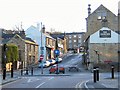
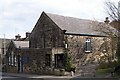
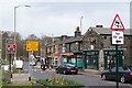
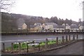
Photos of S35 0XW


Area Information
Living in S35 0XW offers a distinct experience for those seeking a stable residential environment. This specific postcode covers a small residential cluster with a population of 1,868 residents. You will find a tight-knit community where daily life moves at a considered pace rather than a rushed tempo. The area is defined by its housing stock and the demographic profile of its inhabitants, who predominantly fall within the adult ages of 30 to 64 years. This concentration suggests a neighbourhood populated by families, professionals, and those building long-term roots. The character of S35 0XW is shaped by high home ownership levels and a quiet setting free from major environmental planning constraints. There is no flood risk to worry about, nor are there protected wetlands, areas of outstanding natural beauty, or designated woodland affecting future planning decisions. For a homebuyer, this translates to practical certainty regarding safety and development. The cluster provides a contained living space ideal for those who prefer a specific postal code identity over a sprawling town centre lifestyle. You gain a sanctuary where the focus remains on the immediate surroundings and the quality of the homes themselves. People choosing to live in S35 0XW appreciate the balance between isolation and access. While the area is compact, it sits within easy reach of essential services and transport links. The population density supports a quiet atmosphere without the anonymity of a large urban district. This makes S35 0XW a compelling choice for individuals and small families prioritising stability and safety. The small scale ensures that the community feels manageable, yet the connectivity guarantees you are not cut off from the wider region.
- Area Type
- Postcode
- Area Size
- Not available
- Population
- 1868
- Population Density
- 3334 people/km²
The property market in S35 0XW is defined by its primary composition of houses and a strong culture of ownership. With 69% of residents owning their homes, this cluster operates more as an owner-occupied market than a rental hub. This high percentage implies that most properties are let by current owners or have been managed within a stable chain of sales. If you are looking at homes in S35 0XW, you are joining a sector where sellers often list infrequently, further reinforcing the occupied status of the street. The vast majority of the housing stock comprises houses rather than flats or other accommodation types. This structure caters to buyers seeking traditional domestic space, often with gardens or enclosed yards typical of the rural or semi-rural edges of Sheffield. Because the area covers such a small residential cluster, the total number of detached and semi-detached options is limited but focused. This scarcity can drive specific demand for the available stock, particularly from those targeting the local demographic group of adults aged 30 to 64 years. Unlike large investment portfolios in city centres, the properties here serve real, long-term living needs. The high ownership level reduces the number of landlord-led tenancies, meaning you are more likely to meet neighbours and engage with the community. When considering homes in S35 0XW, you are entering a market driven by personal residency rather than short-term gain. This stability often results in better-maintainedExternals and a slower, more deliberate market dynamic compared to high-turnover zones.
House Prices in S35 0XW
No properties found in this postcode.
Energy Efficiency in S35 0XW
Your daily life in S35 0XW is supported by a practical network of retail and leisure options within practical reach. Five retail units serve the area, offering essential shopping needs. You have direct access to Co-op Oughtibridge, Morrisons Daily, and Sainsburys Wadsley, ensuring you can stock your home without extensive travel. These supermarkets provide fresh groceries and household essentials, making routine errands quick and convenient. Transport choices are equally accessible, with five metro stops and three railway stations nearby. The rail network connects you to Sheffield Railway Station, Medowhall Railway Station, and Meadowhall Railway Station, enabling easy trips to the city centre or shopping destinations via rail. For short trips, the metro line offers five stops, such as Middlewood, providing a flexible option for navigating South Yorkshire. These transport links mean you are never isolated, despite the residential nature of the postcode. Beyond shopping and transit, the cluster offers a tranquil setting for daily living. The absence of major planning constraints like protected woodlands or wetlands means the local landscape remains defined by private gardens and open residential space. You can enjoy a straightforward lifestyle where your weekends might involve a walk or a trip to the nearby shops. The presence of these specific amenities ensures that convenience never compromises the quiet character of the neighbourhood.
Amenities
Schools
| Rank | School | Type | Entry gender | Ages |
|---|
Explore more schools in this area
Go to Schools tabDemographics
The community profile of S35 0XW is heavily weighted towards adults, with the majority of residents falling into the 30-to-64-year-old age bracket. The median age across the postcode is 47 years, reflecting a mature population that has likely established themselves in the area. Home ownership stands at 69%, which is significantly higher than the national average. This statistic indicates that most people living here have secured an interest in their property rather than renting temporarily. Accommodation in S35 0XW consists primarily of houses. This type of housing appeals to those looking for space and autonomy over their living environment, fitting well with the needs of the adult demographic residing there. The predominant ethnic group is White, aligning with the broader demographic makeup of many established residential clusters in South Yorkshire. These demographic facts paint a picture of a settled neighbourhood where long-term residents are common. A 69% ownership rate suggests low turnover and a stronglocal identity. You will likely neighbours who have lived in their properties for many years, creating a sense of permanence. The age profile means the area attracts professionals and families in their peak earning and raising years, while the high ownership bars supports the property's value retention. Living in S35 0XW means joining a group that has made a serious investment in their location. This stability often correlates with well-maintained streets and a quieter, more predictable community dynamic.
Household Size
Accommodation Type
Tenure
Ethnic Group
Religion
Household Composition
Age
Household Deprivation
NS-SEC
Explore more demographic insights in this area
Go to Demographics tabPlanning
Planning Constraints
- Flood RiskPremium
- Ramsar Wetland SitesPremium
- Area of Outstanding Natural BeautyPremium
- Protected Nature ReservePremium
- Protected WoodlandPremium