Area Overview for S3 8DQ
Photos of S3 8DQ


Area Information
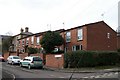
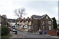
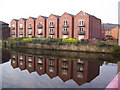
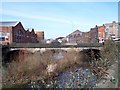
S3 8DQ represents a small, intensively developed residential cluster within Sheffield, covering just 1.3 hectares. This compact footprint supports a population of 2103 people, creating a densely populated neighbourhood where residents live in close proximity. The high population density suggests a shared environment where daily routines often intersect with neighbours. You will find this postcode situated in a modern urban context, distinct from sprawling suburban stretches. Life here moves at a steady pace, driven by the needs of a young demographic rather than families seeking large gardens or quiet country roads. The area functions as a cohesive unit, defined more by its infrastructure and location than by expansive green spaces. For anyone considering homes in S3 8DQ, the compact nature means you get immediate access to nearby streets and facilities without travelling far. This concentration of residents creates a self-contained community vibe, where the layout supports a dynamic social environment. The area is defined by urban living rather than rural tranquillity, offering a practical base for those who prioritise connectivity over solitude.
- Area Type
- Postcode
- Area Size
- 1.3 hectares
- Population
- 2103
- Population Density
- 7645 people/km²
The housing stock within S3 8DQ is exclusively composed of flats, creating a specific market distinct from traditional street house buying. This uniformity in accommodation type means large family homes are not available within this 1.3-hectare boundary. Instead, the market consists entirely of apartment-lifestyle living, catering to the young demographic identified in the demographic data. Home ownership makes up only 17 per cent of households, signalling a market driven by tenants or first-time buyers accessing the property ladder through shared ownership or rentals. For prospective buyers, viewing homes in S3 8DQ will reveal a focus on vertical living rather than horizontal space. The low percentage of owner-occupied properties suggests that long-term residents are relatively uncommon compared to those moving frequently or ending tenancies. If you possess the higher capital required to purchase a flat here, you will enter a competitive market where supply is limited to this specific building style. There are no detached properties to consider; the entire residential cluster is defined by this single accommodation type.
House Prices in S3 8DQ
No properties found in this postcode.
Energy Efficiency in S3 8DQ
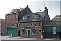
Residents of S3 8DQ benefit from a concentrated network of amenities that are within practical reach of their daily commutes. You have immediate access to five railway stations, including Sheffield Railway Station, Darnall Railway Station, and Medowhall Railway Station, providing excellent public transport links emanating from the immediate neighbourhood. For grocery shopping and daily essentials, five retail options are located nearby, including Spar, Tesco Sheffield, and Asda St. Metro connections are equally strong, with five transport hubs situated on Infirmary Road, leading to Shalesmoor, Shalesmoor to Middlewood, and the Malin Bridge route. The prevalence of these transport nodes and supermarkets means you can fulfill most weekly shopping needs and travel requirements without expending significant time searching for services. The area offers a self-sufficient lifestyle where essential infrastructure is not a distant but accessible part of your routine.
Amenities
Schools
| Rank | School | Type | Entry gender | Ages |
|---|
Explore more schools in this area
Go to Schools tabDemographics
The community profile of S3 8DQ is overwhelmingly youthful, with a median age of just 22 years. Young adults between the ages of 15 and 29 form the most common age range, shaping the social fabric and energy of the locality. This demographic skew indicates an area populated by students, young professionals, or those starting their independent lives. Consequently, the traditional family demographic is absent from the primary population statistics. Regarding housing tenure, a significant portion of residents rent, as current data shows home ownership stands at a low 17 per cent. This low rate reinforces the transient nature typical of areas dominated by young adults who may not yet be looking to put down permanent roots. The predominant ethnic group identified in this cluster is White, reflecting the broader national average for the region. Everyone residing in this area falls under the accommodation type classification of flats, meaning detached houses or semi-detached properties are not a feature of this specific postcode. You are looking at a rental-heavy environment where the residents are generally young, single, or couples without children.
Household Size
Accommodation Type
Tenure
Ethnic Group
Religion
Household Composition
Age
Household Deprivation
NS-SEC
Explore more demographic insights in this area
Go to Demographics tabPlanning
Planning Constraints
- Flood RiskPremium
- Ramsar Wetland SitesPremium
- Area of Outstanding Natural BeautyPremium
- Protected Nature ReservePremium
- Protected WoodlandPremium