Area Overview for S2 2RW
Photos of S2 2RW
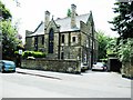
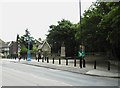
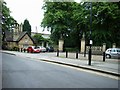
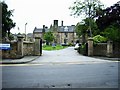
100 photos from this area
Area Information
Key information about the S2 2RW including its size, population, and administrative classification.
- Area Type
- Postcode
- Area Size
- 6176 m²
- Population
- 2674
- Population Density
- 2934 people/km²
House Prices in S2 2RW
8
Properties
£139,192
Average Sold Price
£39,500
Lowest Price
£287,000
Highest Price
Showing 8 properties
| Address | Type | Beds | Baths | Last Sale Price | Last Sale Date | |
|---|---|---|---|---|---|---|
| 83 Farm Bank Road, Sheffield, S2 2RW | house | - | - | £287,000 | May 2021 | |
| 81 Farm Bank Road, Sheffield, S2 2RW | Semi-detached | 3 | - | £167,500 | Sep 2017 | |
| 75 Farm Bank Road, Sheffield, S2 2RW | house | - | - | £160,000 | Jul 2011 | |
| 89 Farm Bank Road, Sheffield, S2 2RW | Semi-detached | 3 | 1 | £85,650 | Jun 2003 | |
| 87 Farm Bank Road, Sheffield, S2 2RW | Semi-detached | 3 | 1 | £95,500 | Oct 2002 | |
| 79 Farm Bank Road, Sheffield, S2 2RW | house | - | - | £39,500 | Sep 1997 | |
| 85 Farm Bank Road, Sheffield, S2 2RW | house | - | - | - | - | |
| 77 Farm Bank Road, Sheffield, S2 2RW | Semi-detached | - | - | - | - |
Energy Efficiency in S2 2RW
Amenities
Schools
| Rank | School | Type | Entry gender | Ages |
|---|
Explore more schools in this area
Go to Schools tabDemographics
Household Size
One person
most common
Accommodation Type
Flats
most common
Tenure
25
majority
Ethnic Group
White
most common
Religion
N/A
most common
Household Composition
N/A
most common
Age
22
median
Young Adults (15-29 years)
most common
Household Deprivation
N/A
with no deprivation
NS-SEC
22
in Lower managerial occupations
Explore more demographic insights in this area
Go to Demographics tabPlanning
Planning Constraints
- Flood RiskPremium
- Ramsar Wetland SitesPremium
- Area of Outstanding Natural BeautyPremium
- Protected Nature ReservePremium
- Protected WoodlandPremium