Area Overview for Malham
Photos of Malham
Area Information
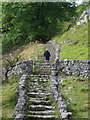
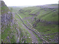
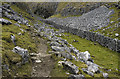
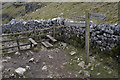
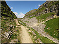
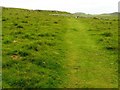
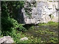
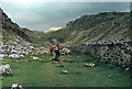
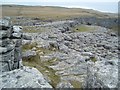
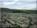
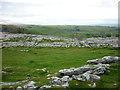
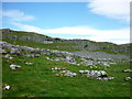
Malham is a civil parish located in North Yorkshire, England, spanning an area of 17.3 km². This village sits within the Yorkshire Dales, recognised for its distinctive karstic scenery and the prominent limestone cliff known as Malham Cove. The parish name derives from a Domesday Book entry translating to a settlement by gravelly places. Since April 2023, the area has been administered by the unitary North Yorkshire Council. Documentation confirms the village has historical roots extending back to the Domesday Book of 1086. While a 2011 census recorded a population of 238 for the parish, historical references suggest broader administrative figures can reach nearly 1,538. You are moving into a location where Roman marching camps once stood on Malham Moor and later, medieval monks from Fountains Abbey and Bolton Priory managed substantial lands. The Dissolution of the Monasteries transformed the landscape, shifting control to tenant farmers. By the 20th century, the area contributed to the designation of the Yorkshire Dales National Park in 1954. Living in Malham means residing in a landscape defined by deep history and dramatic natural formations rather than rapid urbanisation. Homes here include structures with millenary histories. Darnbrook Farm dates to at least the 17th century, while Dale House was constructed between 1700 and 1780. Coronation Villa from 1902 remains a notable early 20th-century building situated in the village. This mix of ancient structures and national park status defines the character of any property you might purchase in the parish. The local environment remains a primary feature, attracting visitors and residents who prioritise natural beauty over metropolitan convenience.
- Area Type
- Parish
- Area Size
- 17.3 km²
- Population
- Not available
- Population Density
- Not available
Demographics
The community profile in Malham reflects a settled, older population. Your neighbours will likely be significantly older on average than the national norm. The median age for residents is 70, indicating that the village predominantly houses seniors. The most common age group is simply listed as the total population, suggesting a lack of significant young family cohorts compared to other areas. When you visit, you will find that three quarters of all households own their homes. This high rate of ownership at 75% points to a stable, long-term community rather than a transient rental market. There is no specific data provided regarding household composition types, such as single-person homes versus families with children, nor is there information available on predominant ethnic groups or religious affiliations. Consequently, the demographic picture relies heavily on the age indicator. The absence of young families correlates with the high median age and suggests a quiet evening environment but potentially fewer local schools catering to primary age groups. Crime statistics offer reassurance to residents, as safety scores indicate low risk. The neighbourhood scores highly for safety, confirming that you can expect below-average crime rates compared to the rest of the country. For a buyer seeking an established older community, the data supports this reality without ambiguity. The demographic structure is clear: an elderly, largely owner-occupied village with minimal pressure from new developments or mobile residents. This stability contributes to the quiet atmosphere typical of a civil parish in the Dales. You are entering a community where generations have lived in the same vicinity, solidifying the village's role as a retirement destination and a retirement-focused residential area.
Household Size
Accommodation Type
Tenure
Ethnic Group
Religion
Household Composition
Age
Household Deprivation
NS-SEC
Explore more demographic insights in this area
Go to Demographics tabPlanning
Planning Constraints
- Flood RiskLocked
- Ramsar Wetland SitesLocked
- Area of Outstanding Natural BeautyLocked
- Protected Nature ReserveLocked
- Protected WoodlandLocked
- Crime RiskLocked