Area Overview for LS9 9XG
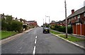
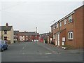
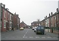
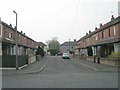
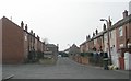
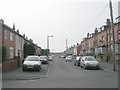
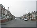
Photos of LS9 9XG

Area Information
LS9 9XG is a small, tightly knit residential postcode area in England with a population of 1701. It is a compact cluster of homes, primarily occupied by adults aged 30–64, with a median age of 22. The area’s proximity to Leeds Railway Station and Cross Gates Railway Station makes it accessible for commuters, while nearby retail hubs like Iceland York and Tesco Leeds offer convenience for daily needs. Despite its modest size, LS9 9XG benefits from excellent digital connectivity, with a broadband score of 100 — the highest possible — ensuring reliable internet for remote work or entertainment. However, the area faces a critical safety challenge: a crime risk score of 28, which is above average, suggesting residents may need to take additional precautions. The absence of protected natural sites or flood risks means the area is free from planning constraints that could complicate development, though the high crime rate remains a concern for families considering relocation.
- Area Type
- Postcode
- Area Size
- Not available
- Population
- 1701
- Population Density
- 9589 people/km²
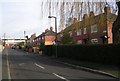
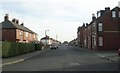
The property market in LS9 9XG is characterised by low home ownership, with just 24% of residents owning their homes. This suggests the area is more of a rental market than an owner-occupied one, which could influence property prices and investment potential. The accommodation type is predominantly houses, which are less common in urban areas, potentially offering more space than flats. For buyers, this means the housing stock is limited to a small number of properties, and competition may be fierce. The area’s proximity to retail and rail networks could make it attractive for investors seeking rental income, but the high crime risk may deter some buyers. Those considering the area should weigh the benefits of house ownership against the local safety profile and the dynamics of a rental-dominated market.
House Prices in LS9 9XG
No properties found in this postcode.
Energy Efficiency in LS9 9XG
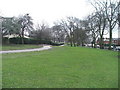
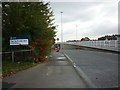
The lifestyle in LS9 9XG is shaped by its proximity to retail and transport hubs. Nearby amenities include Iceland York, Heron Burnmantofts, and Tesco Leeds, offering a range of shopping and dining options. The area’s rail connections to Leeds Railway Station and Cross Gates Railway Station make it easy for residents to access city centres or travel further afield. While the data does not specify parks or leisure facilities, the absence of protected natural areas or AONB coverage suggests the landscape is not dominated by green spaces. The convenience of retail and transport links, combined with excellent broadband, supports a practical, commuter-friendly lifestyle. However, the lack of detailed information on leisure options means residents may need to travel further for recreational activities.
Amenities
Schools
Residents of LS9 9XG have access to two notable schools: Victoria Middle School, a primary school, and East End Park School, a special school. The presence of both a primary and a special school suggests the area caters to families with children requiring tailored education, including those with specific needs. However, no Ofsted ratings are provided, so it is unclear how these schools perform academically. For parents, the mix of school types may be advantageous, offering options for both mainstream and specialist education. The proximity of these schools to LS9 9XG means families can avoid long commutes, though the overall quality of education would depend on individual school performance, which is not detailed in the data.
| Rank | School | Type | Entry gender | Ages |
|---|
Explore more schools in this area
Go to Schools tabDemographics
The community in LS9 9XG is predominantly composed of adults aged 30–64, making up the most common age range, despite a median age of 22. This suggests a mix of older residents and younger individuals, possibly including students or professionals. Home ownership is low, with only 24% of residents owning their homes, indicating that the area is largely a rental market. The accommodation type is primarily houses, not flats, which may appeal to families seeking more space. The predominant ethnic group is White, and while no specific data on deprivation is provided, the low home ownership rate could imply limited economic diversity. The age profile suggests a stable population, but the lack of younger residents under 30 may affect local amenities and services tailored to children or young adults.
Household Size
Accommodation Type
Tenure
Ethnic Group
Religion
Household Composition
Age
Household Deprivation
NS-SEC
Explore more demographic insights in this area
Go to Demographics tabPlanning
Planning Constraints
- Flood RiskPremium
- Ramsar Wetland SitesPremium
- Area of Outstanding Natural BeautyPremium
- Protected Nature ReservePremium
- Protected WoodlandPremium