Area Overview for LS29 6HJ
Photos of LS29 6HJ
Area Information
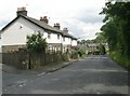
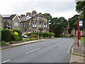
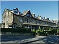
LS29 6HJ represents a specific residential cluster within West Yorkshire, covering an area of 2,343 square metres. You will find a distinct living environment here characterised by a population of 1,596 residents. The area functions as a tight-knit community where daily life revolves around local convenience and established neighbourhood stability. With a population density of 1,474 people per square kilometre, the space feels occupied yet retains the quiet of a residential zone rather than a bustling high street. This postcode offers a direct connection to the wider Menston and Guiseley network without the chaos of a major city centre. Residents here enjoy a setting defined by its residential nature, which appeals to those seeking a settled life away from rapid urban expansion. The location serves as a functional base for commuters accessing Leeds or those preferring a localized lifestyle where amenities are within practical walking or short driving distance. Living in LS29 6HJ means you are part of a defined cluster where the focus remains on house ownership and family stability rather than transient accommodation. The area provides a straightforward choice for homebuyers who understand the value of a specific, non-transient postcode environment.
- Area Type
- Postcode
- Area Size
- 2343 m²
- Population
- 1596
- Population Density
- 1474 people/km²
The property market in LS29 6HJ is almost entirely exclusive to house ownership, with 81 per cent of homes occupied by their owners. You will find that the housing stock consists predominantly of houses, offering a distinct alternative to apartment living found in other parts of Leeds or Bradford. This high level of ownership suggests a stable investment market rather than a transient rental zone. Buyers looking at homes in LS29 6HJ are entering an area where the social fabric is tied to property tenure and long-term residence. The accommodation type data confirms a lack of flats or purpose-built rental blocks in this specific cluster. This makes the area increasingly difficult for first-time buyers or landlords seeking rental yields, as the barrier to entry involves purchase rather than rent. For those seeking to buy, the market reflects a desire for permanence and space typical of the Houses that dominate the landscape. The high ownership percentage also implies that many current owners have lived here for decades, resulting in a slower rate of turnover compared to new-build estates or city centres.
House Prices in LS29 6HJ
Showing 7 properties
| Address | Type | Beds | Baths | Last Sale Price | Last Sale Date | |
|---|---|---|---|---|---|---|
| 1 Meadowcroft, Menston, Ilkley, LS29 6HJ | Bungalow | - | - | £283,000 | Dec 2019 | |
| 3 Meadowcroft, Menston, Ilkley, LS29 6HJ | Semi-detached | 2 | 1 | £175,000 | Apr 2010 | |
| 2 Meadowcroft, Menston, Ilkley, LS29 6HJ | Detached | - | - | £249,950 | May 2007 | |
| 6 Meadowcroft, Menston, Ilkley, LS29 6HJ | Semi-detached | - | - | £77,000 | Jun 1998 | |
| 5 Meadowcroft, Menston, Ilkley, LS29 6HJ | Semi-detached | - | - | £57,500 | Sep 1997 | |
| Plot 36, Land At Grid Ref 416775 443424, Bingley Road, Menston, Ilkley, LS29 6HJ | Detached | - | - | - | - | |
| 4 Meadowcroft, Menston, Ilkley, LS29 6HJ | Semi-detached | - | - | - | - |
Energy Efficiency in LS29 6HJ
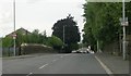
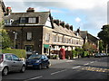
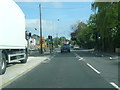
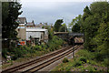
Daily life in LS29 6HJ benefits from immediate access to local retail and transport hubs without the need for lengthy commutes. You can walk or drive a short distance to reach Sainsburys Menston and the Spar nearby for essential groceries. For larger shopping requirements, holders of car keys can easily access Aldi Guiseley, which sits within practical reach of the postcode. Travel needs are met by five railway stations, including Menston Railway Station, Guiseley Railway Station, and Burley, providing direct rail links to Leeds and other major cities. There are also two airports reachable within a short drive, such as Leeds Bradford International Airport and Leeds Bradford Airport, facilitating easy travel for residents. This blend of local high streets and national transport links ensures you have convenience on the doorstep. The presence of these specific venues creates a functional lifestyle where work, shopping, and travel do not require excessive wait times or constant travel.
Amenities
Schools
Families considering homes in LS29 6HJ have access to four primary institutions nearby, all centred around the Menston community name. The closest options include Menston Infant School, which serves the younger years of primary education. You will also find Menston Junior School and Menston Primary School servicing children as they progress through their schooling. All four listed institutions are primary schools, indicating that once children reach secondary age, they will move beyond the immediate vicinity of this postcode. The concentration of primary schools suggests a dedicated catchment area for young families living in the cluster. While the data does not list secondary schools, the presence of three separate primary entities implies a well-established local education network designed to serve residents of LS29 6HJ before any further travel is required. These schools form the backbone of the educational experience for children growing up in this specific residential area.
| Rank | School | Type | Entry gender | Ages |
|---|
Explore more schools in this area
Go to Schools tabDemographics
The community within LS29 6HJ is defined by a mature and established demographic profile. The median age sits at 47 years, confirming that Adults between 30 and 64 years form the most common age range. This indicates a neighbourhood dominated by established families and older children rather than young professionals or students chasing a nightlife scene. You will find that 81 per cent of households are owner-occupiers, a figure that highlights deep roots and long-term stability within the community. Almost all accommodation consists of houses, meaning you will not encounter the density or style associated with apartments or high-rise flats. The predominant ethnic group is White, reflecting the traditional composition of this West Yorkshire locality. There are no significant pockets of deprivation recorded in the available data for this specific postcode, suggesting a consistent standard of living across the cluster. The high home ownership rate combined with the mature age profile paints a picture of a quiet neighbourhood where residents have long-term investment in their properties and local vicinity.
Household Size
Accommodation Type
Tenure
Ethnic Group
Religion
Household Composition
Age
Household Deprivation
NS-SEC
Explore more demographic insights in this area
Go to Demographics tabPlanning
Planning Constraints
- Flood RiskPremium
- Ramsar Wetland SitesPremium
- Area of Outstanding Natural BeautyPremium
- Protected Nature ReservePremium
- Protected WoodlandPremium