Area Overview for LS27 7JD
Photos of LS27 7JD
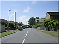
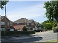
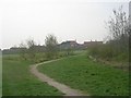

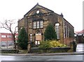

100 photos from this area
Area Information
Key information about the LS27 7JD including its size, population, and administrative classification.
- Area Type
- Postcode
- Area Size
- 1.0 hectares
- Population
- 1893
- Population Density
- 1422 people/km²
House Prices in LS27 7JD
31
Properties
£167,834
Average Sold Price
£52,000
Lowest Price
£295,000
Highest Price
Showing 31 properties
| Address | Type | Beds | Baths | Last Sale Price | Last Sale Date | |
|---|---|---|---|---|---|---|
| 13 Reedsdale Gardens, Gildersome, Morley, LS27 7JD | Semi-detached | 3 | 1 | £294,950 | Jan 2025 | |
| 1 Reedsdale Gardens, Gildersome, Morley, LS27 7JD | Detached | 3 | 1 | £295,000 | Jan 2023 | |
| 9 Reedsdale Gardens, Gildersome, Morley, LS27 7JD | Semi-detached | 3 | 1 | £235,000 | Jul 2021 | |
| 39 Reedsdale Gardens, Gildersome, Morley, LS27 7JD | Bungalow | - | - | £210,000 | Apr 2021 | |
| 61 Reedsdale Gardens, Gildersome, Morley, LS27 7JD | Semi-detached | 4 | - | £243,000 | Apr 2020 | |
| 35 Reedsdale Gardens, Gildersome, Morley, LS27 7JD | house | - | - | £165,000 | Jul 2018 | |
| 53 Reedsdale Gardens, Gildersome, Morley, LS27 7JD | Semi-detached | 3 | 1 | £171,000 | Feb 2015 | |
| 45 Reedsdale Gardens, Gildersome, Morley, LS27 7JD | Semi-detached | 3 | - | £162,000 | Jul 2014 | |
| 43 Reedsdale Gardens, Gildersome, Morley, LS27 7JD | Bungalow | 3 | - | £136,000 | Apr 2013 | |
| 27 Reedsdale Gardens, Gildersome, Morley, LS27 7JD | house | - | - | £172,000 | Oct 2011 |
Page 1 of 4
Energy Efficiency in LS27 7JD
Amenities
Schools
| Rank | School | Type | Entry gender | Ages |
|---|
Explore more schools in this area
Go to Schools tabDemographics
Household Size
Two person
most common
Accommodation Type
Houses
most common
Tenure
67
majority
Ethnic Group
White
most common
Religion
N/A
most common
Household Composition
N/A
most common
Age
47
median
Adults (30-64 years)
most common
Household Deprivation
N/A
with no deprivation
NS-SEC
36
in Lower managerial occupations
Explore more demographic insights in this area
Go to Demographics tabPlanning
Planning Constraints
- Flood RiskPremium
- Ramsar Wetland SitesPremium
- Area of Outstanding Natural BeautyPremium
- Protected Nature ReservePremium
- Protected WoodlandPremium