Area Overview for LS21 1QZ
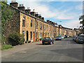
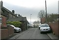
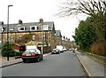
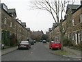
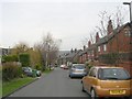
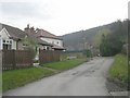
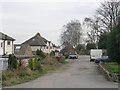
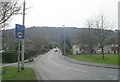
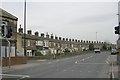
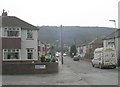
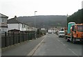
Photos of LS21 1QZ

Area Information
Living in LS21 1QZ means being part of a tightly knit residential cluster in England, where 1,609 people reside across a densely populated area of 1.4 km². This small postcode area is characterised by a mature demographic, with a median age of 47 and a strong presence of adults aged 30–64. The compact nature of LS21 1QZ fosters a quiet, community-focused lifestyle, with homes predominantly owner-occupied (71%) and focused on single-family dwellings. Proximity to amenities like Westgate Primary School, rail stations, and retail hubs such as Waitrose Otley ensures daily convenience. The area’s low population density—1,143 people per km²—contrasts with its accessibility to larger towns, making it a practical choice for those seeking a balance between seclusion and connectivity. For buyers, LS21 1QZ offers a snapshot of traditional English suburbia, where the pace of life is measured and the sense of place is clear.
- Area Type
- Postcode
- Area Size
- Not available
- Population
- 1609
- Population Density
- 1143 people/km²
The property market in LS21 1QZ is dominated by owner-occupied homes, with 71% of residents living in properties they own. The accommodation type is primarily houses, which suggests a focus on larger, family-friendly dwellings rather than apartments or flats. This dynamic positions LS21 1QZ as a low-density, owner-occupied area with limited rental activity. The small size of the postcode area means the housing stock is finite, making it a niche market for buyers seeking specific properties. Given the predominance of houses, properties here are likely to be more spacious than in high-density areas, appealing to those prioritising privacy and space. However, the limited availability of homes may mean that buyers need to consider nearby areas for more options. The market reflects a stable, long-term demographic, with little indication of rapid development or speculative investment.
House Prices in LS21 1QZ
No properties found in this postcode.
Energy Efficiency in LS21 1QZ
The lifestyle in LS21 1QZ is shaped by its proximity to retail, transport, and travel hubs. Within practical reach are supermarkets such as Waitrose Otley, Sainsburys Otley, and Spar Otley, offering a range of shopping options for daily needs. The area’s rail stations—Menston, Guiseley, and Burley—provide access to nearby towns and cities, supporting both commuting and leisure travel. Nearby airports, including Leeds Bradford International Airport, add to the area’s convenience for regional and international travel. While the data does not mention parks or leisure facilities, the presence of multiple retail and transport options suggests a practical, service-oriented lifestyle. The compact nature of LS21 1QZ ensures that amenities are within walking or short driving distance, reducing the need for lengthy trips. This accessibility contributes to a balanced daily life, where convenience and connectivity are prioritised.
Amenities
Schools
Residents of LS21 1QZ have access to two primary schools: Westgate Primary School, which holds an Ofsted rating of ‘good’, and Westgate First School. Both institutions cater to younger children, providing a foundation for local education. The presence of two primary schools in proximity suggests a focus on early education within the community, though secondary schooling options are not listed in the data. For families, the availability of two primary schools offers choice and convenience, reducing the need for long commutes. The ‘good’ rating at Westgate Primary indicates a school that meets or exceeds national standards in teaching and outcomes. While the data does not specify catchment areas or pupil numbers, the presence of two primary schools supports the area’s appeal for families prioritising accessible education.
| Rank | School | Type | Entry gender | Ages |
|---|
Explore more schools in this area
Go to Schools tabDemographics
The community in LS21 1QZ is defined by its age profile, with a median age of 47 and 71% of residents owning their homes. The majority of the population falls within the 30–64 age range, reflecting a stable, adult-oriented demographic. Over 70% of households are owner-occupied, suggesting a long-term commitment to the area. The accommodation type is predominantly houses, indicating a preference for single-family homes over flats or apartments. The predominant ethnic group is White, aligning with broader regional trends. With a population density of 1,143 people per km², the area is relatively compact, which may contribute to a sense of familiarity among residents. This density also means that services and amenities are closely clustered, enhancing the practicality of daily life. The demographic profile suggests a community that values stability, with limited evidence of significant deprivation or transient populations.
Household Size
Accommodation Type
Tenure
Ethnic Group
Religion
Household Composition
Age
Household Deprivation
NS-SEC
Explore more demographic insights in this area
Go to Demographics tabPlanning
Planning Constraints
- Flood RiskPremium
- Ramsar Wetland SitesPremium
- Area of Outstanding Natural BeautyPremium
- Protected Nature ReservePremium
- Protected WoodlandPremium