Area Overview for Linton (Leeds)
Photos of Linton (Leeds)


Area Information
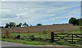
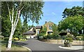
Living in Linton (Leeds) offers a tightly knit experience within a built-up area covering 63.2 hectares. This location sits as a distinct residential pocket within the wider Leeds landscape, where daily life revolves around a specific, manageable footprint. The area functions as a self-contained community, separate from the expansive sprawl of the larger city yet close enough to benefit from nearby urban services. Residents move through neighbourhoods defined by a homogenous character rather than the scattered development found in many modern towns. The scale of Linton (Leeds) means that local streets and amenities remain within easy reach, fostering an environment where many daily tasks can be completed without long journeys. You will find a setting that prioritises simplicity and local focus over high-density urban living. The geography supports a lifestyle where the home is central to activity, and the surrounding 63.2 hectares provide enough space for established gardens and quiet streets without feeling isolated from support services.
- Area Type
- Built Up Area 250
- Area Size
- 63.2 hectares
- Population
- Not available
- Population Density
- Not available
Your daily lifestyle in Linton (Leeds) centres on practical convenience with key amenities located within practical reach. Five major retail outlets provide essential shopping, including Tesco Main, Sainsburys Wetherby, and M&S Wetherby SF. These stores allow you to complete weekly grocery runs and grab essential items without needing to travel deep into the city. For wider mobility, the area offers access to one railway station: Pannal Railway Station. Though a short distance away, this rail link provides a straightforward connection for those needing to reach Leeds or York for leisure or work. The proximity of these specific venues means you do not need to dedicate significant time to commuting to the nearest supermarket or train hub. Shopping trips become manageable errands rather than major outings. The character of the area is shaped by this balance of local self-sufficiency and access to broader transport corridors.
Amenities
Schools
| Rank | School | Type | Entry gender | Ages |
|---|
Explore more schools in this area
Go to Schools tabDemographics
The community profiles of Linton (Leeds) reveal a mature population with a median age of 70 years. This demographic structure indicates an area dominated by older residents, likely retirees or long-term established families who have remained in their homes over decades. The vast majority of households report owning their accommodation outright, with a home ownership rate standing at 92%. This exceptionally high figure suggests a neighbourhood where financial burdens like mortgages have largely been cleared, contributing to financial stability and deep local roots. The housing stock is predominantly occupied by individuals with significant life experience, shaping a community rhythm that values quiet and established routines. You will find very few young professionals or students populating the streets, as the age distribution heavily skews toward later life stages. This consistency in household composition creates a stable environment where neighbours often know each other by name and local events are organised around the needs of an older demographic.
Household Size
Accommodation Type
Tenure
Ethnic Group
Religion
Household Composition
Age
Household Deprivation
NS-SEC
Explore more demographic insights in this area
Go to Demographics tabPlanning
Planning Constraints
- Crime RiskPremium