Area Overview for HX4 0YT
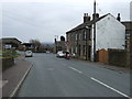
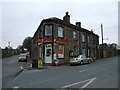
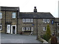
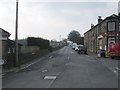
Photos of HX4 0YT


Area Information
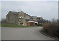
HX4 0YT is a small residential postcode area in England, home to 1,505 people spread across a low-density neighbourhood. The area’s compact size and modest population suggest a tight-knit community, with a population density of 244 people per square kilometre. Daily life here is shaped by its quiet, suburban character, with homes predominantly occupied by owners. The area’s demographics indicate a mature population, with a median age of 47 and a majority of residents aged 30–64. This suggests a stable, family-oriented environment, supported by nearby amenities such as retail stores and rail links. While the area lacks large-scale infrastructure, its proximity to Sowerby Bridge and Halifax railway stations offers connectivity to broader regional networks. The presence of a primary school with a good Ofsted rating adds to its appeal for families. HX4 0YT is not a bustling hub but a place where convenience and tranquillity coexist, ideal for those seeking a settled lifestyle with practical access to essential services.
- Area Type
- Postcode
- Area Size
- Not available
- Population
- 1505
- Population Density
- 244 people/km²
The property market in HX4 0YT is dominated by owner-occupied homes, with 81% of properties in private hands. This high ownership rate indicates a community of long-term residents rather than a rental market. The accommodation type is predominantly houses, which is typical for smaller, rural or semi-rural postcode areas. This suggests a focus on family homes with more space than flats, appealing to those prioritising privacy and garden access. Given the area’s small size and low population density, the housing stock is likely limited in scale, with properties spread across a wider geographical footprint. Buyers should consider that the market may not offer a large selection of properties, and the focus on owner-occupation could mean fewer short-term rental opportunities. The absence of newer developments or high-density housing implies a traditional, perhaps older, housing stock. For those seeking a quiet, stable environment with a strong sense of community, HX4 0YT’s property market aligns with these priorities.
House Prices in HX4 0YT
No properties found in this postcode.
Energy Efficiency in HX4 0YT
Residents of HX4 0YT have access to a range of local amenities within practical reach. Nearby retail options include Co-op Oldham, Tesco Sowerby, and Lidl Pye, providing essential shopping and grocery needs. These stores cater to daily requirements, reducing the need for long journeys to larger centres. The area’s rail stations offer further connectivity, enabling trips to nearby towns for more specialised shopping or leisure. While the data does not mention parks or recreational facilities, the absence of planning constraints such as protected woodlands or AONBs suggests open spaces may be available. The combination of local retail and rail access creates a convenient lifestyle, balancing self-sufficiency with regional connectivity. The quiet, residential nature of the area complements these amenities, offering a relaxed environment for those who prioritise ease of access over large-scale leisure options.
Amenities
Schools
The nearest school to HX4 0YT is Barkisland CofE VA Primary School, which provides education for younger children. Rated ‘good’ by Ofsted, it offers a reliable foundation for primary education. The absence of secondary schools in the immediate vicinity means families may need to consider commuting to nearby towns for secondary education. However, the presence of a well-rated primary school is a significant advantage for families with young children, reducing the need for long-distance travel during early schooling years. The school’s faith-based designation may appeal to those seeking an educational environment with specific values. While the area lacks a comprehensive range of schools, the quality of the primary school aligns with the community’s demographic profile of older, established residents. For parents prioritising strong early education, this school is a key asset of HX4 0YT.
| Rank | School | Type | Entry gender | Ages |
|---|
Explore more schools in this area
Go to Schools tabDemographics
The community in HX4 0YT is predominantly composed of adults aged 30–64, with a median age of 47. This indicates a mature, established population, likely with strong ties to the area. Home ownership is high, with 81% of properties owner-occupied, suggesting long-term residency and financial stability. The area is characterised by houses rather than flats, reflecting a traditional residential layout. The predominant ethnic group is White, though no specific data on diversity or deprivation is provided. The age profile and ownership rates imply a low turnover of residents, fostering a sense of continuity. For families, the presence of a primary school with a good Ofsted rating aligns with the needs of the local demographic. The lack of younger or older residents in significant numbers may mean fewer childcare or retirement-focused amenities, but the area’s stability and safety scores suggest a balanced quality of life for its current inhabitants.
Household Size
Accommodation Type
Tenure
Ethnic Group
Religion
Household Composition
Age
Household Deprivation
NS-SEC
Explore more demographic insights in this area
Go to Demographics tabPlanning
Planning Constraints
- Flood RiskPremium
- Ramsar Wetland SitesPremium
- Area of Outstanding Natural BeautyPremium
- Protected Nature ReservePremium
- Protected WoodlandPremium