Area Overview for HX1 2YP
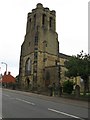
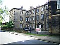
Photos of HX1 2YP


Area Information
HX1 2YP is a small, tightly knit residential postcode in England, home to 1760 people. This area is characterised by its compact size and the presence of family-oriented housing, with 71% of residents owning their homes. The community is predominantly composed of adults aged 30–64, reflecting a mature demographic with established roots. Daily life here is shaped by proximity to essential services, including five retail outlets such as Tesco Halifax and Asda Halifax, and five railway stations, including Halifax and Sowerby Bridge stations. The area’s low crime risk score of 72 and absence of environmental constraints like protected woodlands or AONB coverage make it an appealing choice for those prioritising safety and practicality. While the postcode lacks large-scale amenities, its compact nature ensures residents can access nearby towns and services with ease. For buyers, HX1 2YP offers a blend of stability, convenience, and a low-risk environment, ideal for those seeking a settled lifestyle without the complexities of urban living.
- Area Type
- Postcode
- Area Size
- Not available
- Population
- 1760
- Population Density
- 7083 people/km²
HX1 2YP is predominantly an owner-occupied area, with 71% of homes owned by residents rather than rented. The accommodation type is primarily houses, which suggests a focus on family-sized properties with more space than flats. This contrasts with areas where rental markets dominate, indicating a community of long-term residents rather than transient tenants. The small size of the postcode means the housing stock is limited, but the concentration of houses implies a quieter, more residential character. Buyers should consider the area’s compact nature, as property choices may be fewer compared to larger towns. The high home ownership rate also suggests strong local investment, potentially offering stability for those seeking to purchase a home in a low-risk environment. However, the lack of data on property prices or recent developments means potential buyers must conduct further local research.
House Prices in HX1 2YP
No properties found in this postcode.
Energy Efficiency in HX1 2YP
Life in HX1 2YP is shaped by its proximity to practical amenities. Five retail outlets, including Tesco Halifax and Asda Halifax, provide easy access to groceries and household essentials. The five nearby railway stations, such as Halifax and Sowerby Bridge, facilitate commuting to larger towns and cities, reducing the need for long car journeys. While the data does not mention parks or leisure facilities, the absence of environmental constraints like protected woodlands or AONB coverage suggests open spaces may be available nearby. The area’s compact size means residents can reach services quickly, though larger-scale amenities like cinemas or cultural venues would require travel. The combination of retail, transport, and low environmental risk creates a functional lifestyle for those prioritising convenience and safety.
Amenities
Schools
The nearest school to HX1 2YP is Holy Trinity CofE Infant School, a primary institution serving young children. While no secondary schools are listed in the data, the presence of a primary school suggests the area is well-served for early education. Families with young children may benefit from the school’s proximity, though they would need to travel to nearby towns for secondary education. The absence of additional schools in the data means the educational landscape is limited to primary provision. For those prioritising school choice, the area’s small size may require a broader search beyond HX1 2YP itself. The single listed school does not provide an Ofsted rating, so prospective parents should verify its performance independently.
| Rank | School | Type | Entry gender | Ages |
|---|
Explore more schools in this area
Go to Schools tabDemographics
The population of HX1 2YP is 1760, with a median age of 47, indicating a community skewed towards middle-aged adults. The most common age range is 30–64 years, suggesting a mix of working-age individuals and families. Home ownership is high at 71%, with the majority of properties being houses rather than flats. The predominant ethnic group is White, reflecting a relatively homogenous demographic. This profile points to a stable, long-term resident base with established routines and limited turnover. The absence of specific data on deprivation or diversity metrics means the area’s socioeconomic challenges remain unquantified, but the high home ownership rate and mature age profile imply a generally secure financial position for households. For families, the presence of a primary school and proximity to rail links aligns with the needs of this age group.
Household Size
Accommodation Type
Tenure
Ethnic Group
Religion
Household Composition
Age
Household Deprivation
NS-SEC
Explore more demographic insights in this area
Go to Demographics tabPlanning
Planning Constraints
- Flood RiskPremium
- Ramsar Wetland SitesPremium
- Area of Outstanding Natural BeautyPremium
- Protected Nature ReservePremium
- Protected WoodlandPremium