Area Overview for HX1 1ZA
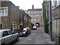
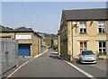
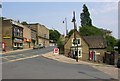
Photos of HX1 1ZA


Area Information
HX1 1ZA is a small, tightly knit residential postcode in England, home to 1,457 residents. The area is characterised by its compact size and focus on traditional housing, with a median age of 47 and a population skewed toward adults aged 30–64. This suggests a community of established professionals and families, many of whom own their homes. The area’s proximity to key amenities, including multiple retail outlets and rail stations, ensures residents have access to daily necessities and commuting options. While it lacks the density of larger towns, HX1 1ZA’s charm lies in its quiet, residential nature and the ease of reaching nearby services. The presence of Compass Community School Willow Park, a special school with a good Ofsted rating, highlights the area’s commitment to education. For those seeking a balance between privacy and connectivity, HX1 1ZA offers a straightforward lifestyle with minimal urban sprawl. Its small footprint means it is best suited for buyers prioritising convenience and a slower pace of life, though its limited size may restrict expansion or development.
- Area Type
- Postcode
- Area Size
- Not available
- Population
- 1457
- Population Density
- 3388 people/km²
The property market in HX1 1ZA is defined by a 54% home ownership rate, indicating a moderate balance between owner-occupied and rental properties. The accommodation type is predominantly houses, which suggests a focus on family-friendly, spacious homes rather than flats or apartments. This makes the area attractive to buyers seeking traditional housing with potential for long-term value retention. However, the small size of the postcode means the housing stock is limited, and buyers may need to consider nearby areas for more options. The owner-occupation rate implies a stable market with less speculative investment, which can be reassuring for those prioritising security. Given the lack of high-rise or modern developments, properties here are likely to retain a classic, low-maintenance appeal. For first-time buyers, the market may present challenges due to its size, but existing residents benefit from a cohesive, community-oriented environment.
House Prices in HX1 1ZA
No properties found in this postcode.
Energy Efficiency in HX1 1ZA
Living in HX1 1ZA offers a blend of convenience and simplicity. Nearby retail options include Sainsburys Halifax, Lidl Pye, and Tesco Sowerby, providing essential shopping within easy reach. These stores cater to daily needs, from groceries to household items, reducing the necessity for long journeys. The area’s rail stations, such as Sowerby Bridge and Halifax, connect residents to broader networks, facilitating travel for work, leisure, or socialising. While the postcode itself is small, the proximity to these amenities ensures a practical lifestyle without the clutter of dense urban environments. The absence of major parks or leisure facilities within the area suggests that outdoor activities may require travel, but the nearby rail links can ease access to larger green spaces or recreational hubs. For those valuing ease of access over sprawling facilities, HX1 1ZA’s lifestyle is efficient and uncluttered.
Amenities
Schools
The nearest school to HX1 1ZA is Compass Community School Willow Park, a special school with a good Ofsted rating. This institution caters to students with specific educational needs, offering tailored support and resources. While the area lacks other schools, the presence of this facility ensures families with children requiring specialist provisions have access to quality education. The absence of primary or secondary schools nearby may necessitate travel for other students, though the good rating suggests the school is well-regarded within its focus area. For prospective buyers, the availability of a special school is a key consideration, particularly for those with children who require such services. The school’s proximity to the area underscores HX1 1ZA’s role as a supportive, if niche, community for families with specific needs.
| Rank | School | Type | Entry gender | Ages |
|---|
Explore more schools in this area
Go to Schools tabDemographics
The population of HX1 1ZA is predominantly adults aged 30–64, with a median age of 47. This indicates a mature community, likely composed of professionals and families who have settled in the area long-term. Home ownership rates stand at 54%, suggesting a mix of owner-occupied properties and rentals. The accommodation type is primarily houses, which aligns with the area’s residential character and may appeal to those seeking larger living spaces. The predominant ethnic group is White, though no data on diversity or deprivation is provided. The age profile implies a stable, low-turnover population, which can contribute to a sense of continuity in local services and community dynamics. However, the lack of younger residents may affect the vibrancy of public spaces and schools. For buyers, the demographic suggests a neighbourhood that prioritises comfort and established living over rapid change.
Household Size
Accommodation Type
Tenure
Ethnic Group
Religion
Household Composition
Age
Household Deprivation
NS-SEC
Explore more demographic insights in this area
Go to Demographics tabPlanning
Planning Constraints
- Flood RiskPremium
- Ramsar Wetland SitesPremium
- Area of Outstanding Natural BeautyPremium
- Protected Nature ReservePremium
- Protected WoodlandPremium