Area Overview for HU9 3DD
Photos of HU9 3DD


Area Information
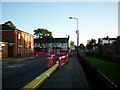
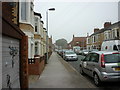
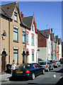
Living in HU9 3DD means being part of a small, tightly knit residential cluster in England, home to 1,386 people. This area is defined by its compact nature, with homes primarily in the form of houses rather than flats, reflecting a traditional, family-oriented layout. The community is predominantly composed of adults aged 30–64, with a median age of 47, suggesting a mature demographic that may value stability and established infrastructure. Daily life here is shaped by proximity to essential services, including multiple rail stations and a ferry terminal, which connect residents to nearby towns and cities. The area’s small size means it is likely to feel close-knit, with limited expansion potential. For those seeking a quiet, residential environment with access to transport and amenities, HU9 3DD offers a blend of practicality and local character. However, its compact nature also means that buyers should consider the limited housing stock and the importance of nearby facilities.
- Area Type
- Postcode
- Area Size
- Not available
- Population
- 1386
- Population Density
- 7245 people/km²
The property market in HU9 3DD is characterised by a 36% home ownership rate, which is notably low compared to national averages. This suggests that the area is more rental-oriented than owner-occupied, potentially offering opportunities for investors or tenants. The accommodation type is predominantly houses, which may appeal to families or those seeking larger living spaces. Given the area’s small size, the housing stock is likely limited, meaning buyers should consider the immediate surroundings for additional options. The presence of houses rather than flats may also indicate a more traditional, suburban character. For those seeking a home here, the market’s compact nature means competition could be fierce, and buyers may need to act swiftly to secure properties.
House Prices in HU9 3DD
No properties found in this postcode.
Energy Efficiency in HU9 3DD
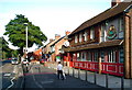
The lifestyle in HU9 3DD is supported by a range of nearby amenities, including five retail outlets such as Heron Southcoates, Iceland Holderness, and Asda Mount, which cater to daily shopping needs. The area’s rail stations and ferry terminal enhance connectivity, allowing residents to access broader regional services. While the data does not specify parks or leisure facilities, the presence of multiple retail and transport options suggests a practical, service-oriented lifestyle. The compact nature of the area means amenities are likely within walking or short driving distance, contributing to convenience. For residents, this balance of retail, transport, and proximity to larger cities offers a functional, if modest, lifestyle.
Amenities
Schools
Residents of HU9 3DD have access to two primary schools: Craven Primary School and Craven Primary Academy. The latter holds an outstanding Ofsted rating, which is a strong indicator of high-quality education. Both institutions cater to younger children, making the area appealing to families with school-age dependents. The presence of two primary schools suggests a focus on early education, though secondary schooling options are not detailed in the data. For families prioritising academic standards, Craven Primary Academy offers a notable advantage. The proximity of these schools to homes in HU9 3DD reinforces the area’s suitability for raising children in a community with established educational infrastructure.
| Rank | School | Type | Entry gender | Ages |
|---|
Explore more schools in this area
Go to Schools tabDemographics
The community in HU9 3DD is predominantly composed of adults aged 30–64, with a median age of 47. This suggests a population that is largely in their prime working years, potentially influencing local services and amenities. Home ownership stands at 36%, indicating that a significant portion of the housing stock is rented out, which may reflect either a rental market or a mix of owner-occupied and leasehold properties. The area is primarily inhabited by people of White ethnicity, with no data provided on other groups. The low home ownership rate could imply a transient population or a reliance on rental properties. For those considering life here, the demographic profile suggests a community that may prioritise practicality over luxury, with services tailored to an established, middle-aged population.
Household Size
Accommodation Type
Tenure
Ethnic Group
Religion
Household Composition
Age
Household Deprivation
NS-SEC
Explore more demographic insights in this area
Go to Demographics tabPlanning
Planning Constraints
- Flood RiskPremium
- Ramsar Wetland SitesPremium
- Area of Outstanding Natural BeautyPremium
- Protected Nature ReservePremium
- Protected WoodlandPremium