Area Overview for HU4 6BP
Photos of HU4 6BP
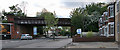
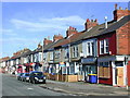
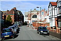

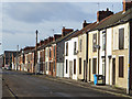
100 photos from this area
Area Information
Key information about the HU4 6BP including its size, population, and administrative classification.
- Area Type
- Postcode
- Area Size
- 1.2 hectares
- Population
- 1559
- Population Density
- 4907 people/km²
House Prices in HU4 6BP
56
Properties
£116,500
Average Sold Price
£42,000
Lowest Price
£245,000
Highest Price
Showing 56 properties
| Address | Type | Beds | Baths | Last Sale Price | Last Sale Date | |
|---|---|---|---|---|---|---|
| 702 Anlaby Road, Kingston Upon Hull, HU4 6BP | Terraced | 5 | 1 | £245,000 | Dec 2022 | |
| 728A Anlaby Road, Kingston Upon Hull, HU4 6BP | Flat | - | - | £90,000 | Jan 2011 | |
| 710 Anlaby Road, Kingston Upon Hull, HU4 6BP | house | - | - | £89,000 | Aug 2001 | |
| 704 Anlaby Road, Kingston Upon Hull, HU4 6BP | house | - | - | £42,000 | Mar 1999 | |
| Flat A, 736 Anlaby Road, Kingston Upon Hull, HU4 6BP | Retail | - | - | - | - | |
| Flat C, 742A Anlaby Road, Kingston Upon Hull, HU4 6BP | Flat | - | - | - | - | |
| Flat A First Floor, 732 Anlaby Road, Kingston Upon Hull, HU4 6BP | Flat | 2 | 1 | - | - | |
| Flat 6, 712 Anlaby Road, Kingston Upon Hull, HU4 6BP | Flat | - | - | - | - | |
| Flat 1, 724-726 Anlaby Road, Kingston Upon Hull, HU4 6BP | Flat | - | - | - | - | |
| Flat 3, 724-726 Anlaby Road, Kingston Upon Hull, HU4 6BP | Flat | - | - | - | - |
Page 1 of 6
Energy Efficiency in HU4 6BP
Amenities
Schools
| Rank | School | Type | Entry gender | Ages |
|---|
Explore more schools in this area
Go to Schools tabDemographics
Household Size
Family (3-5 people)
most common
Accommodation Type
Houses
most common
Tenure
72
majority
Ethnic Group
White
most common
Religion
N/A
most common
Household Composition
N/A
most common
Age
47
median
Adults (30-64 years)
most common
Household Deprivation
N/A
with no deprivation
NS-SEC
27
in Lower managerial occupations
Explore more demographic insights in this area
Go to Demographics tabPlanning
Planning Constraints
- Flood RiskPremium
- Ramsar Wetland SitesPremium
- Area of Outstanding Natural BeautyPremium
- Protected Nature ReservePremium
- Protected WoodlandPremium