Area Overview for HU17 8AY
Photos of HU17 8AY


Area Information
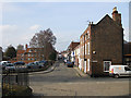
Living in HU17 8AY means being part of a small, tightly knit residential cluster in England, home to 1,581 residents. This area is defined by its quiet, suburban character, with a focus on family-oriented living. The community is predominantly composed of adults aged 30–64, reflecting a mature demographic that prioritises stability and long-term residency. With a median age of 47, the area feels settled, with many residents likely to have lived here for years. The compact nature of the postcode means amenities and services are within practical reach, though the area is not densely populated. Daily life here is shaped by proximity to retail, rail links, and local schools, making it suitable for those seeking a balance between convenience and a slower pace. While the area lacks large-scale urban features, its small size fosters a sense of familiarity. For buyers, HU17 8AY offers a snapshot of traditional English living, with homes primarily in private ownership and a strong emphasis on community. The postcode’s small footprint means it is ideal for those who value proximity to essentials without the bustle of larger towns.
- Area Type
- Postcode
- Area Size
- Not available
- Population
- 1581
- Population Density
- 3511 people/km²
The property market in HU17 8AY is characterised by a 56% home ownership rate, indicating a mix of owner-occupied and rental properties. The predominance of houses over flats or apartments suggests a suburban or semi-rural setting, with larger homes likely to be the norm. This contrasts with areas where high-density housing is more common. For buyers, the small size of the postcode means the housing stock is limited, and the immediate surroundings may offer more options. The high home ownership rate implies a stable market, though the lack of specific data on property prices or trends means it is unclear whether this is a buyer’s or seller’s market. The focus on houses may appeal to families seeking space, but the limited number of properties could make competition fierce. Buyers should consider the area’s compact nature and the potential for limited choice when exploring nearby neighbourhoods. The market here is likely to cater to those prioritising long-term residency over investment.
House Prices in HU17 8AY
No properties found in this postcode.
Energy Efficiency in HU17 8AY
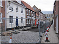
The lifestyle in HU17 8AY is shaped by its proximity to retail and rail amenities. Nearby shops include Tesco Beverley, Heron Beverley, and Asda Beverley, offering a range of grocery and retail options. These stores provide convenience for daily shopping, reducing the need for long trips to larger centres. The rail network, with stations at Beverley, Arram, and Cottingham, connects residents to broader regional services, enhancing accessibility. While the area lacks detailed information on parks or leisure facilities, the presence of retail and transport options suggests a focus on practicality over large-scale recreation. The compact nature of the postcode means amenities are within walking or short driving distance, fostering a sense of convenience. For residents, this balance of retail, transport, and proximity to essential services supports a lifestyle that prioritises ease of access over sprawling urban features. The character of the area is likely defined by its small-scale, community-oriented amenities.
Amenities
Schools
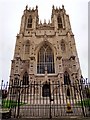
Residents of HU17 8AY have access to two primary schools: Beverley Minster Church of England Voluntary Controlled Primary School and Beverley Minster CE Primary School. Both are primary institutions, though no Ofsted ratings are provided in the data. The presence of two schools within the area suggests a focus on early education, which is crucial for families with young children. The duplication of names may indicate a single school with multiple sites or a shared governance structure, though this is not explicitly stated. For families, having two primary schools nearby offers flexibility in choosing a school that aligns with their preferences. However, the absence of secondary schools in the data means parents may need to look further afield for secondary education. The schools’ Church of England affiliation may also influence their ethos or curriculum, though this is not detailed here. Overall, the area provides a foundation for early education but requires additional planning for older children.
| Rank | School | Type | Entry gender | Ages |
|---|
Explore more schools in this area
Go to Schools tabDemographics
The population of HU17 8AY is 1,581, with a median age of 47, indicating a mature, established community. The majority of residents fall within the 30–64 age range, suggesting a focus on middle-aged adults and families. Home ownership is at 56%, meaning nearly half of properties are owner-occupied, while the remaining are likely rented. The accommodation types are predominantly houses, reflecting a suburban or semi-rural setting rather than flats or apartments. The predominant ethnic group is White, with no specific data on other demographics. This age profile and ownership rate imply a stable, long-term resident base, though the area may lack the diversity seen in larger urban centres. The absence of detailed deprivation data means it is unclear how economic factors influence quality of life, but the high home ownership rate suggests a degree of financial security for many residents. The demographic makeup aligns with a community that values continuity and local ties over rapid change.
Household Size
Accommodation Type
Tenure
Ethnic Group
Religion
Household Composition
Age
Household Deprivation
NS-SEC
Explore more demographic insights in this area
Go to Demographics tabPlanning
Planning Constraints
- Flood RiskPremium
- Ramsar Wetland SitesPremium
- Area of Outstanding Natural BeautyPremium
- Protected Nature ReservePremium
- Protected WoodlandPremium