Area Overview for HU10 6DX
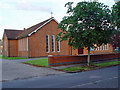
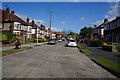
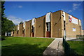
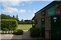
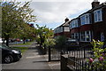
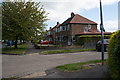
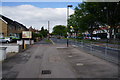
Photos of HU10 6DX


Area Information
Living in HU10 6DX offers a quiet, residential experience in a small cluster of homes with a population of 1,481. This area is characterised by a mature community, with a median age of 47 and a majority of residents aged between 30 and 64. The high home ownership rate of 91% suggests a stable, long-term presence of families and individuals. Daily life here is shaped by proximity to essential services, including five retail outlets such as Tesco Willerby Kirk and Sainsburys Willerby, which provide convenience for shopping and dining. The area’s transport links are robust, with five nearby rail stations, including Hull and Cottingham, offering easy access to larger towns and cities. Digital connectivity is exceptional, with a broadband score of 100, ensuring seamless internet use for work or leisure. While the area lacks natural constraints like protected woodlands or wetlands, its low flood risk and below-average crime rate make it a secure place to live. HU10 6DX is ideal for those seeking a balanced blend of tranquillity, accessibility, and practical amenities.
- Area Type
- Postcode
- Area Size
- Not available
- Population
- 1481
- Population Density
- 2661 people/km²
The property market in HU10 6DX is dominated by owner-occupied homes, with 91% of properties owned by residents rather than rented. This high rate of home ownership indicates a community of long-term residents, many of whom may have purchased properties as family homes. The accommodation type is exclusively houses, which is uncommon in areas with higher rental activity. This suggests a market where buyers are likely to find established, family-friendly properties rather than apartments or newer developments. The small size of the area means the housing stock is limited, and buyers may need to consider nearby regions for more options. For those seeking a home in HU10 6DX, the focus is on stability and security, with properties likely to hold value due to the area’s low crime risk and strong connectivity. However, the limited number of homes may mean competition for available properties.
House Prices in HU10 6DX
No properties found in this postcode.
Energy Efficiency in HU10 6DX
Residents of HU10 6DX have access to a range of nearby amenities that support daily life. The area includes five retail outlets, such as Tesco Willerby Kirk, Morrisons Kirk, and Sainsburys Willerby, ensuring easy access to groceries, household essentials, and dining options. Rail connectivity is strong, with five stations—including Hull and Cottingham—offering direct links to larger towns and cities, which is particularly useful for commuters or those seeking cultural and professional opportunities beyond the area. Brough Airport, though not a major international hub, provides regional travel options for those requiring occasional flights. While the area lacks extensive parks or leisure facilities, the proximity to rail and retail ensures convenience without the need for long commutes. The combination of practical amenities and transport links creates a lifestyle that balances local convenience with broader accessibility, making it suitable for those who value both independence and connection to external services.
Amenities
Schools
| Rank | School | Type | Entry gender | Ages |
|---|
Explore more schools in this area
Go to Schools tabDemographics
The community in HU10 6DX is predominantly composed of adults aged 30 to 64, with a median age of 47. This suggests a population largely in their prime working and family-raising years. Home ownership is exceptionally high at 91%, indicating a strong presence of long-term residents rather than renters. The accommodation type is primarily houses, which aligns with the area’s small, residential character. The predominant ethnic group is White, reflecting a homogenous demographic profile. While no specific data on deprivation is provided, the high home ownership and low crime risk suggest a relatively stable quality of life. The absence of younger or older age groups may mean fewer schools or childcare facilities, but the area’s mature population likely prioritises established amenities and low-risk environments. This demographic structure shapes a community focused on stability, with limited turnover and a cohesive social fabric.
Household Size
Accommodation Type
Tenure
Ethnic Group
Religion
Household Composition
Age
Household Deprivation
NS-SEC
Explore more demographic insights in this area
Go to Demographics tabPlanning
Planning Constraints
- Flood RiskPremium
- Ramsar Wetland SitesPremium
- Area of Outstanding Natural BeautyPremium
- Protected Nature ReservePremium
- Protected WoodlandPremium