Area Overview for HG1 5HF
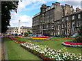
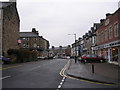
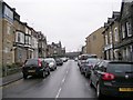
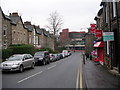
Photos of HG1 5HF


Area Information
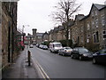
HG1 5HF is a small residential cluster in England, home to 1710 people. Its compact size means it offers a tight-knit community feel, where daily life is shaped by proximity to essential services and transport links. The area’s demographics suggest a mature population, with a median age of 47 and a majority of residents aged 30–64. This reflects a stable, established community, likely centred around family homes and long-term residency. The postcode’s small footprint means it is not a sprawling suburb but a focused residential area, possibly part of a larger town or city. Living here implies access to nearby amenities, including retail hubs and rail connections, which support both daily errands and commuting. The low flood risk and below-average crime rates further enhance its appeal as a safe, secure place to live. For buyers, HG1 5HF represents a blend of practicality and reliability, with minimal environmental or safety concerns. Its character is defined by simplicity and accessibility, making it suitable for those prioritising stability over sprawling urban or rural landscapes.
- Area Type
- Postcode
- Area Size
- Not available
- Population
- 1710
- Population Density
- 7790 people/km²
The property market in HG1 5HF is characterised by a 38% home ownership rate, with flats being the predominant accommodation type. This suggests a housing stock that is largely focused on smaller, perhaps older properties, possibly in a converted or purpose-built block. The relatively low home ownership percentage indicates that a significant portion of the area’s housing is rented, which could be due to the nature of the flats or local rental demand. For buyers, this small area’s property market is likely limited in scale, with limited scope for expansion or new development. The presence of flats may appeal to those seeking low-maintenance living or investment opportunities in rental properties. However, the small population and compact size of HG1 5HF mean that the market is not diverse in terms of property types. Buyers should consider the limited availability of larger homes or alternative housing styles, as the area’s character is defined by its modest, flat-based stock.
House Prices in HG1 5HF
No properties found in this postcode.
Energy Efficiency in HG1 5HF
Residents of HG1 5HF have access to a range of nearby amenities within practical reach. The retail sector is well-represented, with notable stores such as Asda Harrogate, M&S Harrogate, and Tesco Cambridge located close by. These shops provide convenience for everyday shopping, from groceries to clothing. The area’s rail connections, including Harrogate Railway Station and Hornbeam Park Railway Station, offer easy access to broader regional networks, supporting both daily commutes and weekend travel. While the data does not mention parks or leisure facilities, the presence of multiple retail and transport hubs suggests a lifestyle focused on practicality and connectivity. The compact nature of HG1 5HF means amenities are likely clustered within a short distance, reducing the need for long journeys. For those who value accessibility and a mix of retail and transport options, this area offers a straightforward, functional lifestyle.
Amenities
Schools
| Rank | School | Type | Entry gender | Ages |
|---|
Explore more schools in this area
Go to Schools tabDemographics
The population of HG1 5HF is 1710, with a median age of 47. This suggests a community skewed towards middle-aged adults, with the most common age range being 30–64 years. Home ownership in the area stands at 38%, indicating a mix of owner-occupied properties and rental units. The predominant accommodation type is flats, which may reflect a focus on smaller, manageable living spaces. The predominant ethnic group is White, though no specific diversity statistics are provided beyond this. The age profile implies a population that is largely settled, with fewer young families or elderly residents compared to other areas. This demographic structure may influence local services and amenities, which are likely tailored to the needs of adults in their prime working and family years. The absence of detailed data on deprivation or income levels means the quality of life here cannot be fully assessed, but the low crime risk and flood safety suggest a stable environment for residents.
Household Size
Accommodation Type
Tenure
Ethnic Group
Religion
Household Composition
Age
Household Deprivation
NS-SEC
Explore more demographic insights in this area
Go to Demographics tabPlanning
Planning Constraints
- Flood RiskPremium
- Ramsar Wetland SitesPremium
- Area of Outstanding Natural BeautyPremium
- Protected Nature ReservePremium
- Protected WoodlandPremium