Area Overview for HG1 4TR
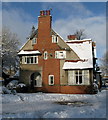
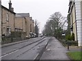
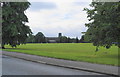
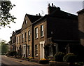
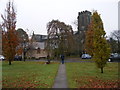
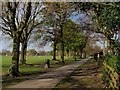
Photos of HG1 4TR


Area Information
HG1 4TR is a small, densely populated residential postcode area in England, home to 2144 people across a compact cluster of homes. Its high population density of 2089 people per square kilometre suggests a tightly knit community, likely centred around local amenities and proximity to Harrogate. Daily life here is shaped by the surrounding infrastructure, with nearby schools, retail outlets, and rail connections forming the backbone of residents’ routines. The area’s proximity to Harrogate, a town known for its historic architecture and cultural attractions, may offer residents access to broader services and leisure opportunities. While the data does not specify the exact boundaries of HG1 4TR, its small size implies a focused, perhaps even insular, character. For buyers, this area could appeal to those seeking a quieter, community-oriented environment, though the density may mean limited space for expansion or development. The presence of multiple schools and rail stations suggests a balance between convenience and the potential for a slower pace of life compared to larger urban centres.
- Area Type
- Postcode
- Area Size
- Not available
- Population
- 2144
- Population Density
- 2089 people/km²
HG1 4TR is primarily an owner-occupied area, with 63% of properties owned by residents rather than rented out. The accommodation type is predominantly houses, which may indicate a focus on family homes or larger properties compared to other areas. This suggests a market where buyers are likely seeking long-term investment rather than short-term rental opportunities. The high home ownership rate could also imply lower turnover, with properties staying in the same hands for extended periods. Given the area’s small size, the housing stock is likely limited, making it a niche market for those prioritising specific local amenities. Buyers should consider the proximity to Harrogate’s services, which may influence property values and desirability. The absence of flats or apartments in the data suggests a lack of high-density housing, which could be a consideration for those needing smaller or more affordable options.
House Prices in HG1 4TR
No properties found in this postcode.
Energy Efficiency in HG1 4TR
Residents of HG1 4TR benefit from nearby retail and rail amenities, including five notable retail outlets such as Co-op Harrogate, Lidl Harrogate, and Co-op Wayside. These stores provide access to essential goods and services, reducing the need for long trips to larger centres. The rail network, with stations like Harrogate and Starbeck, connects the area to broader transport routes, enhancing mobility for both leisure and work. While the data does not specify parks or leisure facilities, the proximity to Harrogate suggests access to cultural and recreational attractions. The combination of retail convenience and rail connectivity supports a lifestyle that balances local convenience with regional accessibility. For those valuing practicality, the presence of multiple shops and transport options ensures daily needs are met without significant effort.
Amenities
Schools
Residents of HG1 4TR have access to a range of educational institutions, including St Robert’s Catholic Primary School, Harrogate, which is a primary school rated ‘good’ by Ofsted. Nearby is Harrogate High School, listed as both a primary and academy school, though its Ofsted rating is ‘satisfactory’. The presence of two primary schools and an academy provides families with options for early education and secondary schooling. The mix of school types may indicate a blend of traditional and more flexible educational approaches. For parents, the availability of multiple schools within practical reach reduces the need for long commutes, though the specific catchment areas and performance metrics are not detailed in the data. The ‘good’ rating at St Robert’s could be a draw for families prioritising quality education, while the academy model at Harrogate High School may offer alternative teaching methods.
| Rank | School | Type | Entry gender | Ages |
|---|
Explore more schools in this area
Go to Schools tabDemographics
The population of HG1 4TR skews towards adults aged 30-64, with a median age of 47, indicating a mature, stable community. Home ownership here is strong, with 63% of residents owning their properties, suggesting a preference for long-term residency over renting. The predominant accommodation type is houses, which may reflect a desire for more space or privacy compared to flats. The majority of residents identify as White, though no specific data on other ethnic groups is provided. With a median age over 40, the area may see fewer young families but a higher proportion of established households. The absence of data on deprivation levels means it is unclear how this affects quality of life, but the high home ownership rate and presence of schools suggest a mix of stability and accessibility.
Household Size
Accommodation Type
Tenure
Ethnic Group
Religion
Household Composition
Age
Household Deprivation
NS-SEC
Explore more demographic insights in this area
Go to Demographics tabPlanning
Planning Constraints
- Flood RiskPremium
- Ramsar Wetland SitesPremium
- Area of Outstanding Natural BeautyPremium
- Protected Nature ReservePremium
- Protected WoodlandPremium