Area Overview for HG1 1SN
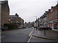
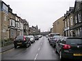
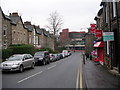
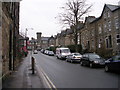
Photos of HG1 1SN


Area Information
HG1 1SN is a small residential postcode area in England, home to 1,759 residents. Its compact size means it is a tightly knit community, with daily life centred around nearby amenities and local infrastructure. The area is served by multiple retail outlets, including Tesco Cambridge, M&S Harrogate, and Sainsburys Harrogate, ensuring residents have access to essential shopping. Rail connectivity is strong, with Harrogate Railway Station, Hornbeam Park Railway Station, and Starbeck Railway Station within practical reach. This makes commuting to nearby towns and cities straightforward. The area’s population is predominantly adults aged 30–64, reflecting a mature demographic. While the community is small, it is served by a range of primary schools, including Harrogate, St Peter’s Church of England Primary School and St Peter’s Church of England Primary School, which may appeal to families. Living in HG1 1SN offers a blend of convenience and accessibility, though its size means it is best suited for those prioritising proximity to services over expansive space.
- Area Type
- Postcode
- Area Size
- Not available
- Population
- 1759
- Population Density
- 5053 people/km²
The property market in HG1 1SN is characterised by a high proportion of rental properties, with only 23% of residents owning their homes. The accommodation type is predominantly flats, which is atypical for a small residential area. This suggests a limited housing stock, possibly concentrated in purpose-built or converted buildings. The low home ownership rate indicates that the area is more of a rental market than an owner-occupied one, which may affect property value growth and buyer demand. For those considering purchasing, the small size of HG1 1SN means the surrounding areas may offer more options. However, the dominance of flats could limit choices for buyers seeking larger or detached properties. The market is likely to cater to tenants rather than investors, with limited scope for capital appreciation.
House Prices in HG1 1SN
No properties found in this postcode.
Energy Efficiency in HG1 1SN
The lifestyle in HG1 1SN is shaped by its proximity to retail and transport hubs. Residents can access major supermarkets like Tesco Cambridge, M&S Harrogate, and Sainsburys Harrogate, ensuring everyday shopping needs are met. Rail stations such as Harrogate Railway Station and Starbeck Railway Station provide easy access to nearby towns and cities, supporting both work and leisure travel. While the area lacks detailed information on parks or leisure facilities, the presence of multiple retail and transport options suggests a practical, service-oriented lifestyle. The community’s small size means amenities are concentrated, which can be both convenient and limiting. For those who prioritise accessibility over space, HG1 1SN offers a functional environment with minimal need to travel far for essentials.
Amenities
Schools
Residents of HG1 1SN have access to three schools within practical reach. Harrogate, St Peter’s Church of England Primary School and St Peter’s Church of England Primary School are both primary schools, providing education for younger children. Harrogate Language Academy is listed as an “other” type, though its specific focus is unclear from the data. The presence of two primary schools may indicate a focus on early education, but the absence of secondary schools suggests families may need to look further afield for older children. This mix of school types could be beneficial for younger families but may pose challenges for those requiring comprehensive education options. The proximity of these schools is a key consideration for prospective buyers prioritising family-friendly amenities.
| Rank | School | Type | Entry gender | Ages |
|---|
Explore more schools in this area
Go to Schools tabDemographics
The population of HG1 1SN has a median age of 47, with the majority of residents falling within the 30–64 age range. This suggests a community of working-age adults and older individuals, rather than a family-focused area. Home ownership is low, at 23%, indicating that most residents rent their accommodation. The predominant housing type is flats, which is unusual for a residential area of this size. The ethnic composition is largely White, with no data provided on other groups. This demographic profile suggests a stable, mature population with limited generational turnover. The low home ownership rate may reflect the area’s small size and limited housing stock, which could impact long-term residency plans. For buyers, this implies a rental-heavy market with few opportunities for property investment.
Household Size
Accommodation Type
Tenure
Ethnic Group
Religion
Household Composition
Age
Household Deprivation
NS-SEC
Explore more demographic insights in this area
Go to Demographics tabPlanning
Planning Constraints
- Flood RiskPremium
- Ramsar Wetland SitesPremium
- Area of Outstanding Natural BeautyPremium
- Protected Nature ReservePremium
- Protected WoodlandPremium