Area Overview for HD8 0PL
Photos of HD8 0PL

Area Information
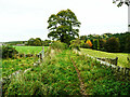
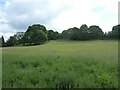
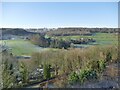
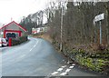
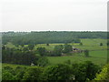
HD8 0PL is a small, tightly knit residential postcode area in England, covering 2,978 square metres and home to 1,589 residents. With a population density of 413 people per square kilometre, it is a compact community where daily life is shaped by proximity to local amenities and a stable demographic. The area is characterised by its mix of housing stock, with a strong emphasis on owner-occupied homes. Neighbourhoods here are likely to be quiet, with a mature population skewed towards adults aged 30–64. Living in HD8 0PL means access to essential services within a short distance, supported by nearby rail links and a range of retail outlets. The area’s small size means it is not sprawling, offering a sense of familiarity and community cohesion. For those seeking a balanced lifestyle, HD8 0PL combines practicality with the comfort of a well-defined local environment, making it a viable choice for those prioritising convenience and a settled way of life.
- Area Type
- Postcode
- Area Size
- 2978 m²
- Population
- 1589
- Population Density
- 413 people/km²
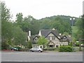
The property market in HD8 0PL is dominated by owner-occupied homes, with 80% of residents owning their properties. This high rate of home ownership indicates a community that values long-term investment and stability. The accommodation type is predominantly houses, which suggests a focus on family-friendly or spacious living arrangements. Given the area’s small size, the housing stock is limited, meaning buyers should consider the scarcity of options and the potential for competition. The concentration of houses also implies that the area is less likely to have a strong rental market, making it more attractive to those seeking a place to settle rather than a short-term investment. For buyers, this means prioritising properties that align with the existing character of the neighbourhood, while being mindful of the limited availability of new developments.
House Prices in HD8 0PL
No properties found in this postcode.
Energy Efficiency in HD8 0PL
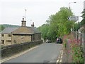
The lifestyle in HD8 0PL is supported by a range of nearby amenities, including five retail outlets such as Morrisons Daily and Co-op Kirkburton, ensuring residents have access to essential shopping and services. The presence of multiple railway stations enhances convenience, allowing easy travel for work, leisure, or social activities. While the area does not include detailed information on parks or leisure facilities, the proximity to rail networks and retail options suggests a practical, community-focused lifestyle. The mix of local shops and transport links means daily errands and commuting can be efficiently managed without long journeys. This balance of accessibility and local character contributes to a functional, everyday living experience tailored to the needs of a mature, settled population.
Amenities
Schools
Residents of HD8 0PL have access to two schools within practical reach: Highburton Church of England Voluntary Controlled First School, a primary school, and Highburton CofE First Academy, an academy. These institutions cater to different educational stages, providing families with a range of options for their children’s schooling. The presence of both a primary school and an academy suggests a commitment to education within the area, though specific Ofsted ratings are not included in the data. For families prioritising local schooling, the proximity of these establishments reduces the need for long commutes. The mix of school types may also reflect a blend of traditional and modern educational approaches, though further details on curriculum or performance are not available.
| Rank | School | Type | Entry gender | Ages |
|---|
Explore more schools in this area
Go to Schools tabDemographics
The community in HD8 0PL is predominantly composed of adults aged 30–64, with a median age of 47. This suggests a population that is largely established, with fewer younger families or retirees compared to other areas. Home ownership is high, with 80% of residents owning their homes, indicating a stable and long-term demographic. The accommodation type is primarily houses, which aligns with the area’s residential character and suggests a preference for more spacious living compared to flats. The predominant ethnic group is White, reflecting a homogenous population. While specific data on deprivation is not provided, the high home ownership rate and moderate population density suggest a relatively stable quality of life, with residents likely to have secure housing and established local ties.
Household Size
Accommodation Type
Tenure
Ethnic Group
Religion
Household Composition
Age
Household Deprivation
NS-SEC
Explore more demographic insights in this area
Go to Demographics tabPlanning
Planning Constraints
- Flood RiskPremium
- Ramsar Wetland SitesPremium
- Area of Outstanding Natural BeautyPremium
- Protected Nature ReservePremium
- Protected WoodlandPremium