Area Overview for HD7 4EP
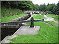
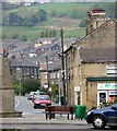
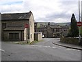
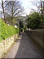
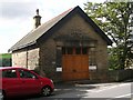
Photos of HD7 4EP


Area Information
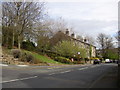
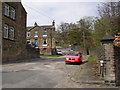
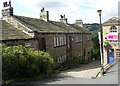
HD7 4EP is a small, tightly knit residential area in England, home to 1,691 residents. Its compact size means it feels like a close-knit community, where daily life is shaped by local amenities and nearby infrastructure. The area’s character is defined by its mix of traditional housing and practical connectivity. With a median age of 47, the population skews towards adults in their 30s to 60s, many of whom own their homes. This demographic suggests a stable, established community with a focus on family living. The area is served by five retail outlets, including multiple Co-ops, and has five railway stations within reach, offering easy access to regional transport networks. While it lacks large-scale urban amenities, its proximity to rail links and modest retail options makes it appealing for those prioritising convenience over sprawling city life. For buyers, HD7 4EP offers a snapshot of rural living with a foothold in the commuter belt, blending quietude with practical accessibility.
- Area Type
- Postcode
- Area Size
- Not available
- Population
- 1691
- Population Density
- 1817 people/km²
HD7 4EP is primarily an owner-occupied area, with 72% of residents holding their homes outright. This high rate of home ownership points to a stable, long-term resident base and limited rental activity. The housing stock is dominated by houses, which are more common than flats or other property types. This suggests a market geared towards families or individuals seeking private, spacious living. Given the area’s small size, the property market is likely limited in scale, with fewer new developments and a focus on existing homes. Buyers should consider that the housing stock may not cater to those seeking modern or high-density living, but it offers a reliable, traditional alternative. The absence of planning constraints like protected woodlands or AONB designations means fewer restrictions on property modifications, which could be an advantage for homeowners looking to adapt their homes.
House Prices in HD7 4EP
No properties found in this postcode.
Energy Efficiency in HD7 4EP
HD7 4EP offers a modest but functional lifestyle, with five retail outlets including multiple Co-ops in Golcar, Leymoor, and Slaithwaite. These shops provide essential services and groceries, reducing the need for long trips to larger centres. The area’s rail stations, such as Slaithwaite and Lockwood, enhance its connectivity, allowing residents to access nearby amenities, employment hubs, and cultural attractions. While the data does not mention parks or leisure facilities, the presence of multiple retail points and rail links suggests a community focused on practicality and convenience. The Co-ops serve as social anchors, offering not just goods but a sense of local identity. For those who prefer a quieter life, the area’s small size and limited urban sprawl may be appealing, though it lacks the diversity of larger towns.
Amenities
Schools
The nearest school to HD7 4EP is Wellhouse Junior and Infant School, a primary institution with an Ofsted rating of ‘good’. This provides families with access to a reputable early education option, though no secondary schools are listed in the data. The presence of a single primary school suggests that parents may need to look beyond the immediate area for secondary education, which could influence decisions about long-term residency. The school’s rating indicates a satisfactory standard of teaching and facilities, which is a key consideration for families prioritising education. However, the absence of additional schools means the area’s educational offerings are limited to primary level, requiring careful planning for older children.
| Rank | School | Type | Entry gender | Ages |
|---|
Explore more schools in this area
Go to Schools tabDemographics
The population of HD7 4EP is predominantly adults aged 30–64, with a median age of 47. This suggests a mature, settled community, likely with strong family ties and a focus on long-term residency. Home ownership is high, with 72% of residents owning their properties, indicating a stable housing market and lower rental demand. The area is composed almost entirely of houses, reflecting a preference for private, standalone living rather than flats or apartments. The predominant ethnic group is White, which aligns with broader trends in rural England. While no specific deprivation data is provided, the high home ownership rate and absence of environmental constraints suggest a generally secure quality of life. The age profile implies a community with a mix of professionals, retirees, and families, all contributing to a balanced local economy.
Household Size
Accommodation Type
Tenure
Ethnic Group
Religion
Household Composition
Age
Household Deprivation
NS-SEC
Explore more demographic insights in this area
Go to Demographics tabPlanning
Planning Constraints
- Flood RiskPremium
- Ramsar Wetland SitesPremium
- Area of Outstanding Natural BeautyPremium
- Protected Nature ReservePremium
- Protected WoodlandPremium