Area Overview for Haworth and Stanbury
Photos of Haworth and Stanbury


Area Information
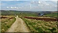
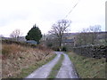
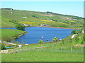
Haworth and Stanbury is a civil parish located in the City of Bradford metropolitan borough within West Yorkshire, England. This parish spans an area of 14.9 square kilometres and comprises the villages of Haworth and Stanbury, together with surrounding moorland to the west. The settlement sits deep within the Pennines, positioned five kilometres south-west of Keighley and thirteen kilometres north of Halifax. You will find it ten kilometres west of Bradford, forming a compact community encompassing nearby villages such as Cross Roads, Oakworth, Oxenhope and Lumbfoot. The current population stands at 1,478 residents, living at a density of ninety-nine people per square kilometre. This area carries a distinct historical weight, having been formed as a civil parish on 1 April 1999. It merged former villages of Haworth, Cross Roads and Stanbury, which held a combined population of 6,566 in 2001 and 6,994 in 2011 before a split occurred on 1 April 2023. Haworth was first recorded as a settlement in 1209, while Stanbury derives its name from Old English meaning stone fort. The region is dominated by its literary heritage, most notably the Brontë Parsonage built between 1778 and 1779, where Charlotte, Emily and Anne Brontë lived. Life here involves navigating narrow lanes and accessing services from Keighley, Halifax or Bradford, placing you in a setting defined by the wool trade, industrial mills and the legacy of the Brontë family. Living in Haworth and Stanbury means embracing a village existence with a direct connection to one of England's most famous literary locations.
- Area Type
- Parish
- Area Size
- 14.9 km²
- Population
- 1478
- Population Density
- 99 people/km²
Demographics
The community within the parish of Haworth and Stanbury shows distinct characteristics regarding who resides there. The median age for the population is seventy, indicating a demographic heavily skewed towards older adults. This high median age reflects the nature of the area as a place where retirement and long-term settlement are common. Three and a half years ago, the average life expectancy in the area stood at twenty-five point eight years, according to an 1850 investigation, though modern demographics show a settled, mature population today. You live in a neighbourhood where the most common age range is recorded as Age: Total, without specific breakdowns provided for younger cohorts. Home ownership is the primary form of tenure, with seventy-three per cent of residents owning their homes outright or with a mortgage. This high rate of ownership suggests a stable, long-term community rather than a transient rental market. Household composition, accommodation types, predominant ethnic groups and religious affiliations are recorded in the data aggregates but specific details are not broken down by category in this dataset. The area does not provide separate metrics for deprivation levels, focusing instead on foundational demographic metrics. For you, buying a home here means joining a community where the majority of neighbours are owners seeking stability. The population density of ninety-nine residents per square kilometre across the 14.9 square kilometre parish creates a close-knit environment without being overcrowded.
Household Size
Accommodation Type
Tenure
Ethnic Group
Religion
Household Composition
Age
Household Deprivation
NS-SEC
Explore more demographic insights in this area
Go to Demographics tabPlanning
Planning Constraints
- Flood RiskLocked
- Ramsar Wetland SitesLocked
- Area of Outstanding Natural BeautyLocked
- Protected Nature ReserveLocked
- Protected WoodlandLocked
- Crime RiskLocked