Area Overview for DN37 7BW
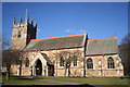
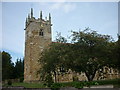
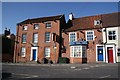
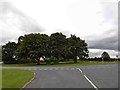
Photos of DN37 7BW


Area Information
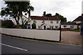
DN37 7BW is a small, compact residential area in Lincolnshire, England, covering just 1.6 hectares. With a population of 2008 people, it has a high population density of 1379 people per square kilometre, reflecting a tightly knit community. The area is characterised by its mix of housing and proximity to essential services, making it a practical choice for those seeking a balance between space and convenience. Its small size means it is likely to be surrounded by larger rural or semi-rural landscapes, though the immediate environment is focused on residential living. The area’s demographics suggest a mature, stable population, with a median age of 47 and a majority of residents aged between 30 and 64. This indicates a community that is likely to be family-oriented or composed of long-term residents. Living here means being close to local amenities, schools, and transport links, all within a short distance. The area’s size and density make it ideal for those who prioritise a quiet, established neighbourhood without the need for a large estate.
- Area Type
- Postcode
- Area Size
- 1.6 hectares
- Population
- 2008
- Population Density
- 1379 people/km²
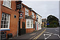
DN37 7BW is primarily an owner-occupied area, with 79% of homes owned by residents rather than rented. The accommodation type is predominantly houses, which is unusual for a small postcode area but may reflect the surrounding rural or semi-rural context. This suggests that the housing stock is likely to be traditional, with limited modern developments. The small size of the area means the property market is limited in scale, with fewer options for buyers. However, the high home ownership rate indicates a stable demand for properties, particularly among those seeking a quiet, established home. Buyers should consider the area’s compactness, as the immediate surroundings may offer more housing options. The presence of houses rather than flats or apartments may appeal to those preferring single-family homes. Given the area’s size and demographics, property values are likely to reflect the local demand and the characteristics of the housing stock.
House Prices in DN37 7BW
Showing 38 properties
| Address | Type | Beds | Baths | Last Sale Price | Last Sale Date | |
|---|---|---|---|---|---|---|
| 8 Church Lane, Laceby, DN37 7BW | house | 3 | 1 | £165,000 | Dec 2023 | |
| 20 Church Lane, Laceby, DN37 7BW | Terraced | 3 | 1 | £115,000 | Sep 2023 | |
| 34 Church Lane, Laceby, DN37 7BW | Terraced | 3 | - | £171,000 | Dec 2021 | |
| 24 Church Lane, Laceby, DN37 7BW | house | 4 | - | £136,000 | Aug 2021 | |
| 56 Church Lane, Laceby, DN37 7BW | house | - | - | £130,000 | Aug 2021 | |
| 29 Church Lane, Laceby, DN37 7BW | Bungalow | - | - | £260,000 | Dec 2020 | |
| 58 Church Lane, Laceby, DN37 7BW | house | 2 | - | £142,000 | Oct 2020 | |
| 52 Church Lane, Laceby, DN37 7BW | Terraced | 2 | 1 | £95,000 | Jul 2019 | |
| 4 Church Lane, Laceby, DN37 7BW | Terraced | 3 | 1 | £115,000 | May 2019 | |
| 26 Church Lane, Laceby, DN37 7BW | Terraced | 3 | 1 | £120,000 | Dec 2018 |
Energy Efficiency in DN37 7BW
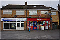
The lifestyle in DN37 7BW is defined by its proximity to essential amenities and services. Within a short distance, residents can access five retail outlets, including the Lincolnshire Co-operative Co-op, Spar, and Morrisons Grange, offering a range of shopping and convenience options. The area’s rail stations—Healing, Great Coates, and Stallingborough—provide easy access to broader regional networks, facilitating travel for work, leisure, or social purposes. While the area is small, its amenities are practical and sufficient for daily needs. The presence of multiple retail options and transport links suggests a community that values convenience and connectivity. However, the lack of larger leisure or entertainment facilities means residents may need to travel further for cultural or recreational activities. Overall, the lifestyle here is functional, with a focus on accessibility and local services.
Amenities
Schools
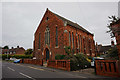
Residents of DN37 7BW have access to two primary schools within practical reach: Stanford Junior and Infant School and Laceby Stanford Primary Academy. Both institutions cater to younger children, providing essential education for families in the area. The presence of two primary schools suggests a focus on early education, though no data on their Ofsted ratings or academic performance is available. For families with children, this proximity to schools is a significant advantage, reducing the need for long commutes. However, the absence of secondary schools in the immediate vicinity may require students to travel further for secondary education. The mix of school types—both primary—indicates a community that prioritises early learning, but buyers should consider the availability of secondary education options if this is a concern.
| Rank | School | Type | Entry gender | Ages |
|---|
Explore more schools in this area
Go to Schools tabDemographics
The population of DN37 7BW is predominantly adults aged 30 to 64, with a median age of 47. This suggests a community of middle-aged individuals, likely settled in their careers and families. Home ownership is high, with 79% of residents owning their homes, indicating a stable and long-term population. The accommodation type is primarily houses, rather than flats or apartments, which aligns with the area’s residential character. The predominant ethnic group is White, and no specific data on deprivation or diversity is provided, but the high home ownership rate and age profile suggest a community with relatively low economic volatility. The compact size of the area, combined with its adult population, may mean fewer young families or students, though the presence of two primary schools nearby suggests some households with children. The area’s demographics paint a picture of a mature, established neighbourhood where residents are likely to be familiar with one another, fostering a sense of local cohesion.
Household Size
Accommodation Type
Tenure
Ethnic Group
Religion
Household Composition
Age
Household Deprivation
NS-SEC
Explore more demographic insights in this area
Go to Demographics tabPlanning
Planning Constraints
- Flood RiskPremium
- Ramsar Wetland SitesPremium
- Area of Outstanding Natural BeautyPremium
- Protected Nature ReservePremium
- Protected WoodlandPremium