Area Overview for DN37 7AF
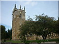
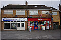
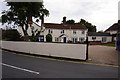
Photos of DN37 7AF


Area Information
DN37 7AF is a small, compact residential area in England, covering just 1.2 hectares and home to 2,008 residents. Its population density of 1,379 people per square kilometre suggests a tightly knit community, though the area’s size means it remains a quiet, low-traffic environment. The postcode is primarily composed of houses, reflecting a demographic skewed towards adults aged 30–64, with a median age of 47. This suggests a stable, established population, many of whom are likely long-term residents. The area’s proximity to primary schools and rail stations adds practicality for families and commuters. While there are no major landmarks or natural features within the postcode itself, its location near Lincolnshire’s rural heartland offers a balance between accessibility and tranquillity. Daily life here is likely characterised by a mix of local shopping, commuter rail links, and a strong sense of community, with residents benefiting from a low crime rate and minimal environmental risks. For buyers, DN37 7AF represents a small, self-contained area with clear advantages for those prioritising safety, convenience, and a settled lifestyle.
- Area Type
- Postcode
- Area Size
- 1.2 hectares
- Population
- 2008
- Population Density
- 1379 people/km²
The property market in DN37 7AF is characterised by a high rate of home ownership—79% of residents own their homes—indicating a strong preference for long-term residency over rental living. The area is composed almost entirely of houses, with no mention of flats or apartments, which suggests a focus on family homes and single-family dwellings. Given the small size of the postcode (1.2 hectares), the housing stock is likely limited, making it a niche market for buyers seeking a specific, compact location. The absence of rental properties implies that the area is not a hotspot for investors or short-term lets, but rather a place where residents have established roots. For buyers, this means a market that prioritises stability and community over speculative growth. The proximity to rail stations and schools may also contribute to the area’s appeal, though the limited size of the postcode means that properties are likely to be in close proximity to one another. This creates a tightly knit neighbourhood where property values are likely to reflect the area’s safety, convenience, and established character.
House Prices in DN37 7AF
Showing 24 properties
| Address | Type | Beds | Baths | Last Sale Price | Last Sale Date | |
|---|---|---|---|---|---|---|
| 36 Butt Lane, Laceby, DN37 7AF | Semi-detached | 3 | 1 | £161,000 | Mar 2023 | |
| 32 Butt Lane, Laceby, DN37 7AF | Semi-detached | 3 | 1 | £175,000 | Feb 2023 | |
| 38 Butt Lane, Laceby, DN37 7AF | Retail | 3 | 1 | £220,000 | Jun 2022 | |
| 26 Butt Lane, Laceby, DN37 7AF | Semi-detached | - | - | £145,000 | Apr 2022 | |
| 40 Butt Lane, Laceby, DN37 7AF | house | - | - | £234,000 | Jan 2022 | |
| 20 Butt Lane, Laceby, DN37 7AF | house | 3 | 1 | £150,000 | Mar 2021 | |
| 22 Butt Lane, Laceby, DN37 7AF | house | - | - | £120,000 | Aug 2020 | |
| 8 Butt Lane, Laceby, DN37 7AF | Terraced | 4 | 1 | £117,500 | Jul 2020 | |
| 18 Butt Lane, Laceby, DN37 7AF | house | - | - | £112,500 | May 2020 | |
| 2 Butt Lane, Laceby, DN37 7AF | Semi-detached | 3 | 1 | £110,000 | Feb 2020 |
Energy Efficiency in DN37 7AF
The lifestyle in DN37 7AF is shaped by its proximity to essential amenities within walking or short driving distance. Local retail options include a Lincolshire Co-operative Co-op, Spar, and Morrisons Grange, providing access to groceries, household goods, and everyday essentials. These shops cater to the needs of a small, established community, reducing the necessity for long trips to larger centres. The area’s rail stations—Healing, Great Coates, and Stallingborough—offer further connectivity, enabling residents to access broader services, leisure opportunities, or employment in nearby towns. While the data does not mention parks or recreational spaces, the absence of environmental constraints like protected woodlands or AONB designations suggests that open spaces may be available nearby. The combination of retail, rail access, and a low-risk environment creates a practical, self-sufficient lifestyle, ideal for those seeking convenience without sacrificing safety or community cohesion.
Amenities
Schools
Residents of DN37 7AF have access to two primary schools within practical reach: Stanford Junior and Infant School and Laceby Stanford Primary Academy. Both institutions cater to younger children, providing a foundation for early education in the area. While no Ofsted ratings are specified in the data, the presence of two primary schools suggests a focus on family-friendly infrastructure. For parents, this means a choice of local schools without the need to travel far, which is particularly valuable in a small, compact postcode like DN37 7AF. The absence of secondary schools in the immediate vicinity may require families to consider commuting to nearby towns for higher education, but the proximity to rail stations could ease this transition. Overall, the availability of primary schools reinforces the area’s suitability for families, offering a practical starting point for children’s education.
| Rank | School | Type | Entry gender | Ages |
|---|
Explore more schools in this area
Go to Schools tabDemographics
The population of DN37 7AF is predominantly adults aged 30–64, with a median age of 47. This suggests a mature, stable community, likely with a high proportion of families and working professionals. Home ownership is strong, with 79% of residents owning their homes, a figure that indicates a low rental market and a focus on long-term residency. The area is composed almost entirely of houses, rather than flats or apartments, which aligns with the demographic profile of older, established households. The predominant ethnic group is White, though no specific data on diversity or deprivation is provided. The absence of significant deprivation metrics implies that the area’s quality of life is likely consistent with its safety and infrastructure. With a population density of 1,379 people per square kilometre, the area is neither overly crowded nor isolated, offering a balance between community cohesion and personal space. This profile suggests a neighbourhood where residents are likely to be familiar with one another, with a focus on stability and family-oriented living.
Household Size
Accommodation Type
Tenure
Ethnic Group
Religion
Household Composition
Age
Household Deprivation
NS-SEC
Explore more demographic insights in this area
Go to Demographics tabPlanning
Planning Constraints
- Flood RiskPremium
- Ramsar Wetland SitesPremium
- Area of Outstanding Natural BeautyPremium
- Protected Nature ReservePremium
- Protected WoodlandPremium