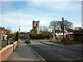
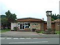
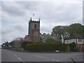
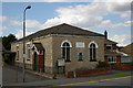
Area Overview for DN20 0DT
Photos of DN20 0DT


Area Information
Living in DN20 0DT offers a distinctly residential experience within a very compact footprint. This specific postcode covers merely 1592 square metres, housing a population of 1595 people. The density here is exceptionally high by standard metrics, yet the setting remains fundamentally residential. You are looking at a small cluster where the community is tightly knit due to the limited physical space. This area is situated in England and functions as a contained neighbourhood rather than a sprawling suburb. The tightness of the plot means daily life revolves around a central core where residents know their neighbours. Because the land area is so restricted, the sense of place is immediate. You get direct access to the essential services that define your day-to-day existence without needing to travel far. The area is characterised by this intense concentration of people on a tiny scale, creating a neighbourhood that feels more like a village within a larger estate. Your surroundings are defined by this concentration, making every street and plot significant to the local identity.
- Area Type
- Postcode
- Area Size
- 1592 m²
- Population
- 1595
- Population Density
- 2364 people/km²
The housing market in DN20 0DT is defined by a specific type of tenure and stock. With 67% of homes owned by residents, this is firmly an owner-occupied area rather than a private landlord housing association or high-rental zone. The accommodation type is strictly houses, indicating that the property portfolio consists of detached or semi-detached family homes. There are no flats or apartments recorded for this postcode, which limits the types of buyers who fit the built environment. Prospective buyers must look for houses that suit the needs of the 30 to 64-year-old demographic that dominates the street profiles. This concentration of owner-occupiers usually creates a stable market where homes are sold with established histories. The small area size of 1592 square metres means supply is intrinsically limited. When purchasing in DN20 0DT, you are entering a market where inventory is scarce and competition focuses on these specific house types. Funding for owner-occupiers dominates the local economy more than rental yields.
House Prices in DN20 0DT
Showing 3 properties
| Address | Type | Beds | Baths | Last Sale Price | Last Sale Date | |
|---|---|---|---|---|---|---|
| 15 Brooklands Avenue, Broughton, DN20 0DT | Bungalow | 5 | 2 | £328,500 | Jun 2025 | |
| 19 Brooklands Avenue, Broughton, DN20 0DT | Bungalow | 3 | 3 | £177,500 | Aug 2021 | |
| 17 Brooklands Avenue, Broughton, DN20 0DT | Detached | - | - | - | - |
Energy Efficiency in DN20 0DT
Your daily lifestyle in DN20 0DT revolves around a compact set of practical amenities just out of immediate reach but well within practical commuting distance. Retail options include Co-op Broughton, Lincolnshire Co-operative Co, and Aldi Bridge, providing full grocery and household supplies. These three venues offer a robust selection for shopping needs. For commuters requiring rail access, four stations are nearby including Brigg Railway Station, Scunthorpe Railway Station, and Barnetby Railway Station. These links connect you to broader regional networks quickly. The estate does not contain a mainline station itself, meaning you will drive or use local shuttles to reach Boag or Bamford to begin your journey to bigger hubs. You have access to 5 retail venues and 4 rail termini within your practical daily network. This combination allows for a self-sufficient routine where you stock up at Co-op or Aldi and catch a train from a nearby hub without feeling isolated. The proximity to these specific shops and stations defines the convenience of living here.
Amenities
Schools
Families living near Broughton rely on a specific educational provision within walking or short driving distance. Broughton Primary School serves the local area as a primary education provider. The data identifies it as a primary school, catering to infants and juniors before secondary transfer. This is the only named educational institution available for this specific location. Because there are no secondary schools listed in the immediate vicinity, older children will need to travel outside the DN20 0DT cluster for further education. The presence of a primary school suggests the area attracts families with younger children who benefit from a short commute. Parents planning their life in this postcode must factor in the single primary option provided. While the specific Ofsted rating is not cited in the provided information, the existence of Broughton Primary School confirms access to state-maintained education. You should verify current ratings with the Department for Education if that metric is a priority for your decision.
| Rank | School | Type | Entry gender | Ages |
|---|
Explore more schools in this area
Go to Schools tabDemographics
The community profile of DN20 0DT reveals a mature demographic with clear ownership patterns. The median age is 47 years, and the most common age range consists of adults between 30 and 64 years old. This indicates a population dominated by families or individuals in their productive middle years rather than young singles or elderly retirees. House ownership stands at 67%, showing that the majority of residents own their homes. This high level of equity suggests stability and long-term commitment to the locality. The predominant ethnic group is White, which aligns with the broader established character of the postcode. Accommodation types are exclusively houses, meaning no flats or apartments exist within this specific cluster. The absence of rental stock in the data implies a market driven by owner-occupiers. You are moving into an area where homeownership is the standard model. The age structure supports a need for practical living spaces rather than luxury urban amenities.
Household Size
Accommodation Type
Tenure
Ethnic Group
Religion
Household Composition
Age
Household Deprivation
NS-SEC
Explore more demographic insights in this area
Go to Demographics tabPlanning
Planning Constraints
- Flood RiskPremium
- Ramsar Wetland SitesPremium
- Area of Outstanding Natural BeautyPremium
- Protected Nature ReservePremium
- Protected WoodlandPremium