Area Overview for DN2 5DU
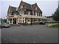
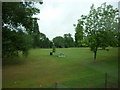
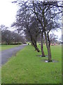
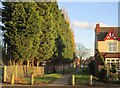
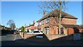
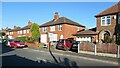
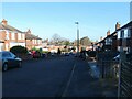
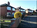
Photos of DN2 5DU

Area Information
Living in DN2 5DU means being part of a tightly knit residential cluster in England’s South Yorkshire region. With a population of 1,636 people spread across 1.47 km², this area is characterised by its compact size and high population density of 1,111 people per square kilometre. It is a place where daily life is shaped by proximity to essential services and a mix of local amenities. The area’s appeal lies in its balance between residential tranquillity and practical connectivity. Residents benefit from nearby rail links, including Doncaster and Bentley stations, which provide access to regional hubs. The presence of schools such as Doncaster St Aidan’s CofE Primary and Curlew Middle School suggests a focus on family-oriented living. While the area lacks large-scale commercial or recreational spaces, its small footprint ensures that essential services are within walking or short driving distance. DN2 5DU is not a sprawling suburb but a defined postcode area where community dynamics are shaped by its limited size and the density of its housing stock.
- Area Type
- Postcode
- Area Size
- Not available
- Population
- 1636
- Population Density
- 1111 people/km²
The property market in DN2 5DU is dominated by owner-occupied homes, with 61% of properties held by residents rather than landlords. This suggests a community where long-term investment is common, and property values may be more stable compared to rental-heavy areas. The predominant accommodation type is houses, which is unusual in many urban postcode areas but aligns with the small, residential nature of DN2 5DU. This housing stock likely includes semi-detached and terraced homes, typical of South Yorkshire’s suburban layouts. For buyers, this means the area is not a high-turnover rental market but one where properties are likely to remain in the same hands for years. The compact size of the area means that property searches are limited to a small radius, and buyers should consider the proximity of amenities and transport links when evaluating homes.
House Prices in DN2 5DU
No properties found in this postcode.
Energy Efficiency in DN2 5DU
Daily life in DN2 5DU is shaped by its proximity to essential amenities and community hubs. Local shops such as Lidl Intake, Co-op EGMF, and Iceland Thorne RP provide grocery and retail needs within practical reach. The area’s rail stations, including Doncaster and Bentley, offer access to broader regional networks, while the Robin Hood Doncaster Sheffield Airport provides an alternative for travel. Though the data does not specify parks or leisure facilities, the presence of multiple schools and retail options suggests a focus on practical living over large-scale recreation. The compact size of the area means that amenities are concentrated, making it convenient for residents who prioritise ease of access over expansive open spaces. The mix of retail and transport options supports a lifestyle that balances convenience with the need for connectivity.
Amenities
Schools
Residents of DN2 5DU have access to a range of educational institutions, including primary schools and other facilities. Doncaster St Aidan’s CofE Primary and Nursery School and Curlew Middle School are both primary schools, offering early years and key stage education. St George’s CofE First School is another primary option, while The Long Sandall Centre and Nexus Centre are categorised as other educational or community facilities. The presence of multiple primary schools suggests that families have choices for younger children, though secondary education options are not specified in the data. The mix of school types indicates a focus on foundational education, but prospective buyers should verify the availability of secondary schools and their proximity to the area.
| Rank | School | Type | Entry gender | Ages |
|---|
Explore more schools in this area
Go to Schools tabDemographics
The community in DN2 5DU is predominantly composed of adults aged 30–64, with a median age of 47. This suggests a mature population, likely with established careers and family ties. Home ownership is strong, with 61% of properties occupied by owners rather than renters, indicating a stable housing market. The accommodation types are primarily houses, which aligns with the area’s residential character. The predominant ethnic group is White, reflecting a homogenous demographic profile. This does not necessarily indicate a lack of diversity but highlights the data’s focus on the most common group. The absence of specific deprivation data means the area’s quality of life cannot be assessed in terms of economic hardship, but the high home ownership rate and family-centric age range suggest a community prioritising long-term residency and stability.
Household Size
Accommodation Type
Tenure
Ethnic Group
Religion
Household Composition
Age
Household Deprivation
NS-SEC
Explore more demographic insights in this area
Go to Demographics tabPlanning
Planning Constraints
- Flood RiskPremium
- Ramsar Wetland SitesPremium
- Area of Outstanding Natural BeautyPremium
- Protected Nature ReservePremium
- Protected WoodlandPremium