Area Overview for DN18 5SL
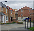
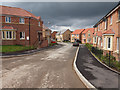
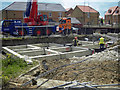
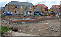
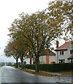
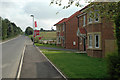
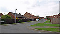
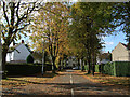
Photos of DN18 5SL


Area Information
DN18 5SL is a small, tightly knit residential area in England, covering just 3.7 hectares and home to 2,498 residents. Its compact size means the community feels close-knit, with a population density of 2,472 people per square kilometre. This postcode area is typical of a rural or semi-rural cluster, where homes are spread across a limited footprint. Daily life here is shaped by its modest scale — residents are likely to know their neighbours, and local amenities are within walking or short driving distance. The area’s low flood risk and absence of protected natural sites suggest it is a practical, low-maintenance place to live. With a median age of 47 and a population skewed toward adults aged 30–64, the community is stable and mature. This makes DN18 5SL appealing to those seeking a quiet, established environment without the pressures of larger urban centres. Its proximity to rail stations and a nearby airport also hints at a balance between local convenience and regional connectivity. For buyers, the area offers a snapshot of English suburbia: modest in size, focused on homes rather than high-density living, and defined by its practical, everyday appeal.
- Area Type
- Postcode
- Area Size
- 3.7 hectares
- Population
- 2498
- Population Density
- 2472 people/km²
The property market in DN18 5SL is characterised by high home ownership (77%) and a focus on houses rather than flats or apartments. This suggests a community where long-term residency is the norm, with properties likely to be family homes rather than short-term investments. The prevalence of houses indicates a preference for private, standalone living, which may appeal to buyers seeking space and privacy. However, the small area size (3.7 hectares) means the housing stock is limited, and the immediate surroundings may not offer a wide range of property types. For buyers, this could mean a competitive market with fewer options, particularly for those seeking alternative accommodation styles. The high home ownership rate also implies that rental properties are less common, which might reduce availability for renters. Prospective buyers should consider the area’s compact nature when assessing long-term suitability, as expansion or development is unlikely to significantly alter the local property landscape.
House Prices in DN18 5SL
Showing 60 properties
| Address | Type | Beds | Baths | Last Sale Price | Last Sale Date | |
|---|---|---|---|---|---|---|
| 51 Riverbank Rise, Barton Upon Humber, DN18 5SL | house | - | - | £270,000 | Dec 2025 | |
| 52 Riverbank Rise, Barton Upon Humber, DN18 5SL | Detached | 4 | 2 | £267,500 | Dec 2025 | |
| 53 Riverbank Rise, Barton Upon Humber, DN18 5SL | Detached | 4 | 2 | £265,000 | Jul 2025 | |
| 26 Riverbank Rise, Barton Upon Humber, DN18 5SL | Terraced | 2 | 1 | £135,000 | Mar 2025 | |
| 15 Riverbank Rise, Barton Upon Humber, DN18 5SL | Detached | 4 | 2 | £323,000 | Jan 2023 | |
| 32 Riverbank Rise, Barton Upon Humber, DN18 5SL | Terraced | 2 | 1 | £127,500 | Jun 2022 | |
| 48 Riverbank Rise, Barton Upon Humber, DN18 5SL | Retail | 4 | 3 | £262,000 | Mar 2022 | |
| 38 Riverbank Rise, Barton Upon Humber, DN18 5SL | house | - | - | £234,000 | Oct 2021 | |
| 5 Riverbank Rise, Barton Upon Humber, DN18 5SL | house | - | - | £245,000 | Sep 2021 | |
| 42 Riverbank Rise, Barton Upon Humber, DN18 5SL | Detached | 4 | 3 | £210,000 | Jun 2021 |
Energy Efficiency in DN18 5SL
Living in DN18 5SL offers access to a mix of retail, transport, and regional connections. The area is within practical reach of five retail outlets, including Lidl Barton-upon, Asda Barton-Upon, and Spar, providing everyday shopping convenience. Rail stations such as Barton, Hessle Rail Stn, and Barrow Haven Railway Station are nearby, linking residents to broader networks for commuting or travel. The proximity to Brough Airport, though likely a smaller facility, adds to the area’s accessibility. While there are no named parks or leisure facilities in the data, the absence of protected natural sites suggests open spaces may be limited. The retail and transport options available indicate a practical, functional lifestyle, with amenities focused on daily needs rather than leisure. For those prioritising convenience and connectivity over extensive recreational facilities, DN18 5SL provides a straightforward, no-frills approach to living.
Amenities
Schools
| Rank | School | Type | Entry gender | Ages |
|---|
Explore more schools in this area
Go to Schools tabDemographics
The population of DN18 5SL is predominantly adults aged 30–64, with a median age of 47. This suggests a mature, settled community, likely with families and professionals in their prime working years. Home ownership is high, at 77%, indicating a strong preference for long-term residency over rental living. The accommodation type is primarily houses, which aligns with the area’s low density and suburban character. The predominant ethnic group is White, which reflects broader regional demographics but does not preclude diversity in smaller pockets. With no data on deprivation levels, it is unclear how economic factors might influence quality of life. However, the high home ownership rate and stable age profile suggest a relatively secure, low-volatility environment. The absence of significant demographic diversity may appeal to those seeking a uniform, predictable community but could limit cultural or social variety. Overall, the area is defined by its stability, with a population that values permanence and a built environment tailored to family-oriented living.
Household Size
Accommodation Type
Tenure
Ethnic Group
Religion
Household Composition
Age
Household Deprivation
NS-SEC
Explore more demographic insights in this area
Go to Demographics tabPlanning
Planning Constraints
- Flood RiskPremium
- Ramsar Wetland SitesPremium
- Area of Outstanding Natural BeautyPremium
- Protected Nature ReservePremium
- Protected WoodlandPremium