Area Overview for DN18 5NL
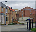
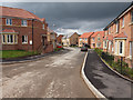
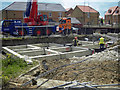
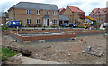
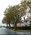
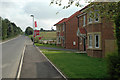
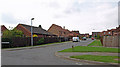
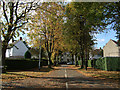
Photos of DN18 5NL


Area Information
Living in DN18 5NL means being part of a small, tightly knit residential cluster in England. This area covers 7,008 square metres and is home to 1,866 people, giving it a population density of 97 people per square kilometre. The community is characterised by its low population and compact layout, making it ideal for those seeking a quieter, more manageable environment. The area’s small size means residents are likely to know their neighbours, fostering a sense of familiarity. With a median age of 47, the demographic skews towards adults aged 30–64, suggesting a stable, established population. Most homes are owner-occupied, with 86% of properties in private hands, indicating a long-term commitment to the area. Daily life here is shaped by proximity to local amenities, including retail outlets, rail stations, and a nearby airport. The low crime risk and absence of environmental constraints such as protected woodlands or wetlands make it a practical choice for families and professionals alike.
- Area Type
- Postcode
- Area Size
- 7008 m²
- Population
- 1866
- Population Density
- 97 people/km²
DN18 5NL is predominantly an owner-occupied area, with 86% of homes in private hands. This high level of home ownership suggests a stable market where properties are likely to retain value over time. The accommodation type is primarily houses, which is unusual for areas with higher population densities but fits DN18 5NL’s small, low-density layout. This means the housing stock is likely to consist of individual homes rather than flats or apartments, appealing to buyers seeking space and privacy. Given the area’s compact size, the property market is limited to a small number of homes, making it a niche market. Buyers should consider the proximity to nearby amenities such as rail stations and retail outlets, which enhance the area’s practicality. The absence of rental properties indicates that most residents are long-term homeowners.
House Prices in DN18 5NL
Showing 9 properties
| Address | Type | Beds | Baths | Last Sale Price | Last Sale Date | |
|---|---|---|---|---|---|---|
| 5 Warwick Drive, Barton Upon Humber, DN18 5NL | Detached | 4 | 2 | £300,000 | Aug 2025 | |
| 9 Warwick Drive, Barton Upon Humber, DN18 5NL | Bungalow | - | - | £255,000 | Apr 2021 | |
| 1A Warwick Drive, Barton Upon Humber, DN18 5NL | Detached | 4 | 3 | £230,000 | Feb 2019 | |
| 13 Warwick Drive, Barton Upon Humber, DN18 5NL | Bungalow | 3 | - | £130,000 | May 2012 | |
| 3 Warwick Drive, Barton Upon Humber, DN18 5NL | house | - | - | £180,000 | May 2008 | |
| 11 Warwick Drive, Barton Upon Humber, DN18 5NL | Detached | - | - | £135,000 | Jun 2007 | |
| 1 Warwick Drive, Barton Upon Humber, DN18 5NL | Bungalow | - | - | £78,000 | Oct 1997 | |
| 15 Warwick Drive, Barton Upon Humber, DN18 5NL | Terraced | - | - | - | - | |
| 7 Warwick Drive, Barton Upon Humber, DN18 5NL | Detached | - | - | - | - |
Energy Efficiency in DN18 5NL
Residents of DN18 5NL have access to a range of nearby amenities, including five retail outlets such as Lidl Barton-upon, Asda Barton-Upon, and Spar. These shops provide essential services and convenience for daily needs. The area is also served by five rail stations, offering easy access to commuting and regional travel. The proximity to Brough Airport adds to the area’s connectivity, making it practical for those requiring air travel. While the data does not specify parks or leisure facilities, the presence of retail and transport options suggests a functional lifestyle. The combination of local shopping, rail links, and airport access ensures residents can meet both practical and recreational needs without long commutes.
Amenities
Schools
The nearest school to DN18 5NL is Bowmandale Primary School, which is rated ‘outstanding’ by Ofsted. This primary school serves the local community and is likely to be a key consideration for families. The absence of secondary schools or other educational institutions in the data means the area’s school options are limited to primary education. For families requiring secondary schooling, proximity to nearby towns or cities would be essential. The ‘outstanding’ rating suggests high-quality teaching and facilities, which can be a significant draw for homebuyers. However, the lack of additional schools means parents may need to travel further for secondary education.
| Rank | School | Type | Entry gender | Ages |
|---|
Explore more schools in this area
Go to Schools tabDemographics
The population of DN18 5NL is predominantly adults aged 30–64, with a median age of 47. This suggests a mature, settled community with fewer young families or elderly residents compared to other areas. Home ownership is high, with 86% of properties owned by their occupants, reflecting a preference for long-term residency. The accommodation type is primarily houses, which aligns with the area’s low population density and residential character. The predominant ethnic group is White, though specific data on diversity or deprivation is not provided. The absence of detailed diversity metrics means the community’s composition remains broadly defined. The low crime risk score of 84/100 indicates a safer environment compared to national averages, which can positively influence quality of life and property desirability.
Household Size
Accommodation Type
Tenure
Ethnic Group
Religion
Household Composition
Age
Household Deprivation
NS-SEC
Explore more demographic insights in this area
Go to Demographics tabPlanning
Planning Constraints
- Flood RiskPremium
- Ramsar Wetland SitesPremium
- Area of Outstanding Natural BeautyPremium
- Protected Nature ReservePremium
- Protected WoodlandPremium