Area Overview for DN18 5DU
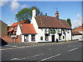
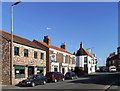
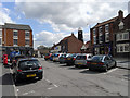
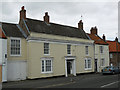
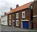
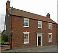
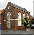
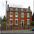
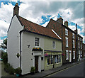
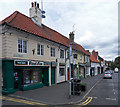
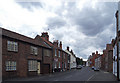
Photos of DN18 5DU

Area Information
DN18 5DU is a small, tightly packed residential postcode in England, covering just 2.8 hectares and home to 1713 residents. Its compact size means the area is densely populated, with 62,116 people per square kilometre, creating a closely knit community. This is a place where daily life revolves around local amenities and proximity to essential services. The area is predominantly residential, with a focus on family-oriented living, reflected in its median age of 47 and the prevalence of adult residents aged 30–64. While the area lacks large-scale infrastructure, its accessibility to nearby rail stations and retail hubs ensures residents can easily connect to broader networks. The presence of Baysgarth School, rated ‘good’ by Ofsted, underscores its appeal for families. Living here means navigating a balance between a small, familiar community and the practicality of nearby transport links, making it a viable choice for those prioritising convenience over expansive space.
- Area Type
- Postcode
- Area Size
- 2.8 hectares
- Population
- 1713
- Population Density
- 2801 people/km²
The property market in DN18 5DU is dominated by owner-occupied homes, with 61% of residents owning their properties. The area’s housing stock consists primarily of houses, which are typically larger and more suited to families than flats. This suggests a market skewed towards long-term residents rather than short-term renters, though the exact proportion of rental properties is not specified. Given the small size of the area—just 2.8 hectares—housing availability is likely limited, making it a competitive market for buyers. The concentration of houses may also mean fewer modern developments, which could be a consideration for those seeking newer properties. For buyers, the compact nature of the area means proximity to amenities is a key advantage, though the limited space may restrict expansion or redevelopment opportunities.
House Prices in DN18 5DU
Showing 7 properties
| Address | Type | Beds | Baths | Last Sale Price | Last Sale Date | |
|---|---|---|---|---|---|---|
| 5 The Bridges, Barton Upon Humber, DN18 5DU | Detached | 4 | 2 | £400,000 | Feb 2023 | |
| 4 The Bridges, Barton Upon Humber, DN18 5DU | Detached | 4 | 1 | £440,000 | Oct 2020 | |
| 6 The Bridges, Barton Upon Humber, DN18 5DU | house | 4 | 1 | £330,000 | Oct 2017 | |
| 3 The Bridges, Barton Upon Humber, DN18 5DU | house | - | - | £260,000 | Dec 2015 | |
| 1 The Bridges, Barton Upon Humber, DN18 5DU | Detached | - | - | £245,000 | Jul 2006 | |
| 2 The Bridges, Barton Upon Humber, DN18 5DU | house | - | - | £120,000 | Nov 2001 | |
| Former Site Of 3, The Bridges, Barton Upon Humber, DN18 5DU | Detached | - | - | - | - |
Energy Efficiency in DN18 5DU
The lifestyle in DN18 5DU is shaped by its proximity to essential amenities. Within practical reach are five retail outlets, including Spar, Co-op Barton, and Morrisons Daily Barton-on, offering everyday shopping needs. The area’s rail network, with five nearby stations, provides easy access to dining, leisure, and employment opportunities beyond the postcode. While specific parks or recreational spaces are not listed in the data, the absence of protected natural areas or constraints suggests residents may have access to local green spaces outside the immediate area. The presence of Brough Airport adds a layer of convenience for travel, though the area’s compact size means social and cultural activities are likely concentrated in nearby towns. Overall, the mix of retail, transport, and basic services supports a functional, if modest, lifestyle.
Amenities
Schools
The nearest school to DN18 5DU is Baysgarth School, a primary school with a ‘good’ Ofsted rating. This provides families with a locally available, mid-tier educational option, though the absence of secondary schools or additional educational facilities within the area may require commuting. The presence of a rated primary school is a significant draw for families, offering a stable foundation for early education. However, the single school listed does not indicate a comprehensive range of educational choices, which could be a limitation for those requiring specialist provision or a broader selection of schools. For parents prioritising proximity to schools, Baysgarth School’s rating suggests it meets acceptable standards, but further research into secondary education options would be necessary for long-term planning.
| Rank | School | Type | Entry gender | Ages |
|---|
Explore more schools in this area
Go to Schools tabDemographics
The community in DN18 5DU is predominantly composed of adults aged 30–64, with a median age of 47. This suggests a mature, stable population, likely with established careers and family ties. Home ownership is high at 61%, indicating a strong presence of long-term residents. The area is characterised by houses rather than flats, reflecting a traditional, family-focused housing stock. The predominant ethnic group is White, which aligns with broader regional demographics. The population density—over 62,000 people per square kilometre—means the area is highly compact, fostering a sense of proximity but also limiting personal space. While no specific data on deprivation is provided, the high home ownership and presence of essential services suggest a moderate quality of life, though the lack of diversity in ethnic composition may impact social dynamics.
Household Size
Accommodation Type
Tenure
Ethnic Group
Religion
Household Composition
Age
Household Deprivation
NS-SEC
Explore more demographic insights in this area
Go to Demographics tabPlanning
Planning Constraints
- Flood RiskPremium
- Ramsar Wetland SitesPremium
- Area of Outstanding Natural BeautyPremium
- Protected Nature ReservePremium
- Protected WoodlandPremium