Area Overview for DN17 3TR
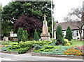
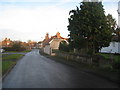
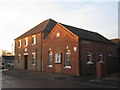
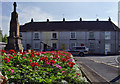
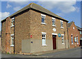
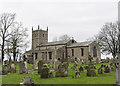
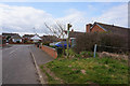
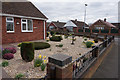
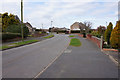
Photos of DN17 3TR

Area Information
DN17 3TR is a small, densely populated postcode area in England, covering just 1305 square metres and home to 1372 residents. Despite its compact size, it supports a community with a high population density of over 1 million people per square kilometre. This area is characterised by its residential cluster, where most properties are houses rather than flats, reflecting a settled, family-oriented demographic. The median age of 47 suggests a mature population, with the majority of residents falling within the 30-64 age range. Daily life here is shaped by proximity to essential services and a low crime risk, making it appealing for those seeking a quiet, secure environment. The area’s limited size means amenities are tightly clustered, with nearby shops and rail links providing practical connectivity. For buyers, DN17 3TR offers a snapshot of a tightly knit community where ownership is prevalent, and the landscape is free from environmental constraints like protected woodlands or flood zones.
- Area Type
- Postcode
- Area Size
- 1305 m²
- Population
- 1372
- Population Density
- 1667 people/km²
The property market in DN17 3TR is dominated by owner-occupied homes, with 78% of properties in private hands. This suggests a stable market where long-term residency is common, rather than a rental-heavy area. The accommodation type is exclusively houses, which is unusual for a small postcode area but may reflect the region’s historical development patterns. Given the limited size of the area, the housing stock is likely to be tightly clustered, with little scope for new builds. Buyers should consider that the market is small and potentially niche, with properties likely to be in demand due to the area’s low crime risk and proximity to rail links. However, the compact nature of DN17 3TR means that property values may be influenced more by location within the cluster than by broader regional trends.
House Prices in DN17 3TR
Showing 8 properties
| Address | Type | Beds | Baths | Last Sale Price | Last Sale Date | |
|---|---|---|---|---|---|---|
| 7 Manley Court, Messingham, DN17 3TR | Flat | - | - | - | - | |
| 6 Manley Court, Messingham, DN17 3TR | Flat | - | - | - | - | |
| 1 Manley Court, Messingham, DN17 3TR | Flat | - | - | - | - | |
| 2 Manley Court, Messingham, DN17 3TR | Flat | - | - | - | - | |
| 4 Manley Court, Messingham, DN17 3TR | Flat | - | - | - | - | |
| 5 Manley Court, Messingham, DN17 3TR | Flat | - | - | - | - | |
| 8 Manley Court, Messingham, DN17 3TR | Flat | - | - | - | - | |
| 3 Manley Court, Messingham, DN17 3TR | Flat | - | - | - | - |
Energy Efficiency in DN17 3TR
Life in DN17 3TR is shaped by its proximity to essential retail and transport hubs. The area includes notable retail venues such as Lincolnshire Co-operative Co and Heron Riddings, providing everyday shopping and services within easy reach. Rail connectivity to Scunthorpe, Kirton Lindsey, and Althorpe adds convenience for commuting or travel, enhancing the area’s appeal for those who value accessibility. While the small size of the postcode means amenities are tightly clustered, this also fosters a sense of community where local shops and transport links are integral to daily routines. The absence of large-scale leisure facilities or parks is offset by the area’s compact design, which minimises travel time to nearby services. For residents, this balance of practicality and proximity defines the lifestyle, with a focus on convenience and local engagement.
Amenities
Schools
| Rank | School | Type | Entry gender | Ages |
|---|
Explore more schools in this area
Go to Schools tabDemographics
The community in DN17 3TR is predominantly composed of adults aged 30-64, with a median age of 47. This suggests a stable population with strong ties to the area, likely including families and long-term residents. Home ownership is high, with 78% of properties owned by their occupants, indicating a preference for long-term residency over rental living. The accommodation type is primarily houses, which aligns with the area’s small size and compact layout. The predominant ethnic group is White, reflecting a homogenous demographic profile. The population density of 1,051,517 people per square kilometre is exceptionally high, which may influence the character of the neighbourhood, fostering a close-knit community where proximity to amenities and neighbours is a defining feature. This density also means that daily life is centred around shared spaces and local services, with little room for expansion.
Household Size
Accommodation Type
Tenure
Ethnic Group
Religion
Household Composition
Age
Household Deprivation
NS-SEC
Explore more demographic insights in this area
Go to Demographics tabPlanning
Planning Constraints
- Flood RiskPremium
- Ramsar Wetland SitesPremium
- Area of Outstanding Natural BeautyPremium
- Protected Nature ReservePremium
- Protected WoodlandPremium