Area Overview for DN17 3NG
Photos of DN17 3NG
Area Information
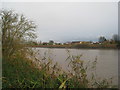
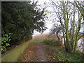
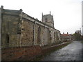
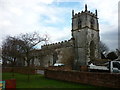
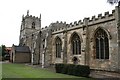
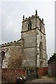
DN17 3NG is a small residential postcode area in North Lincolnshire, England, encompassing parts of the village of Burringham. The area covers 3 hectares and is home to 1,466 residents, with a population density of 165 people per square kilometre. This compact cluster is part of the Scunthorpe post town, situated near the River Trent and the B1450 road. Burringham has a distinct character shaped by its history, including a Grade II listed Church of St John the Baptist and a statue of Lady Claire Linton, a local figure known for her community work. The area is served by three railway stations—Althorpe, Crowle, and Scunthorpe—linking it to nearby towns. While small, it offers a mix of historical charm and practical connectivity, with nearby retail hubs like Tesco and M&S. Living here means a quiet, close-knit community with access to essential services, though the area’s flood risk is a notable consideration for prospective buyers.
- Area Type
- Postcode
- Area Size
- 3.0 hectares
- Population
- 1466
- Population Density
- 165 people/km²
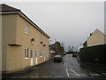
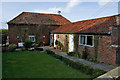
DN17 3NG is an owner-occupied area, with 80% of homes owned by their residents rather than rented out. The accommodation type is predominantly houses, which is typical for rural or semi-rural postcode areas in England. This suggests a market skewed towards family homes and larger properties, rather than apartments or smaller dwellings. The small size of the area—just 3 hectares—means the housing stock is limited, with few new developments likely. For buyers, this implies a niche market where properties are likely to be in high demand, especially given the area’s proximity to Scunthorpe and its historical appeal. However, the limited size also means competition for available homes, and buyers should consider the potential for future growth in nearby towns rather than within DN17 3NG itself.
House Prices in DN17 3NG
Showing 30 properties
| Address | Type | Beds | Baths | Last Sale Price | Last Sale Date | |
|---|---|---|---|---|---|---|
| 24 South View Avenue, Burringham, DN17 3NG | house | - | - | £125,000 | Jan 2023 | |
| 27 South View Avenue, Burringham, DN17 3NG | Bungalow | - | - | £160,000 | Sep 2021 | |
| 17 South View Avenue, Burringham, DN17 3NG | Semi-detached | 3 | 1 | £138,000 | May 2021 | |
| 20 South View Avenue, Burringham, DN17 3NG | house | - | - | £159,950 | Sep 2020 | |
| 19 South View Avenue, Burringham, DN17 3NG | house | - | - | £99,000 | Oct 2019 | |
| 29 South View Avenue, Burringham, DN17 3NG | Bungalow | 3 | 2 | £130,000 | Oct 2016 | |
| 2 South View Avenue, Burringham, DN17 3NG | Semi-detached | 3 | 1 | £78,000 | Apr 2016 | |
| 23 South View Avenue, Burringham, DN17 3NG | Semi-detached | - | - | £105,000 | Oct 2015 | |
| 4 South View Avenue, Burringham, DN17 3NG | Semi-detached | 3 | - | £105,000 | Aug 2006 | |
| 16 South View Avenue, Burringham, DN17 3NG | Semi-detached | - | - | £84,000 | Oct 2004 |
Energy Efficiency in DN17 3NG
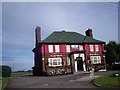
Life in DN17 3NG is centred around its village character, with amenities that cater to both practical needs and local traditions. The area’s proximity to Scunthorpe ensures access to larger retail outlets, including Tesco, M&S, and Aldi, while the village itself retains a sense of community through venues like the Take a Gander pub on the High Street. Historical landmarks such as the Church of St John the Baptist and the statue of Lady Claire Linton add cultural depth. The nearby railway stations provide easy access to regional hubs, and the B1450 road links the area to surrounding towns. While the village is small, its mix of retail, transport, and heritage sites offers a balanced lifestyle, blending rural tranquillity with practical connectivity.
Amenities
Schools
The nearest school to DN17 3NG is the Gunness and Burringham Church of England Primary School, which serves the local community with a good Ofsted rating. This primary school is positioned halfway between Gunness and Burringham, making it accessible to residents of both villages. The school’s rating indicates a satisfactory standard of education, though families requiring secondary schooling would need to look further afield, as no secondary schools are listed in the data. The presence of a primary school with a good rating is a key consideration for families, offering a reliable foundation for early education. However, the absence of secondary schools in the immediate area may influence decisions about long-term residency, particularly for households with older children.
| Rank | School | Type | Entry gender | Ages |
|---|
Explore more schools in this area
Go to Schools tabDemographics
The population of DN17 3NG is predominantly adults aged 30–64, with a median age of 47. This suggests a mature, established community, likely with a strong presence of families and professionals. Home ownership is high at 80%, indicating a stable housing market where most residents live in their own homes rather than renting. The accommodation type is primarily houses, reflecting a residential area with larger properties rather than flats or apartments. The predominant ethnic group is White, which aligns with broader trends in rural North Lincolnshire. The population density of 165 people per square kilometre is relatively low, contributing to a less crowded, more spaced-out living environment. This demographic profile suggests a community focused on long-term residency, with limited turnover and a strong local identity.
Household Size
Accommodation Type
Tenure
Ethnic Group
Religion
Household Composition
Age
Household Deprivation
NS-SEC
Explore more demographic insights in this area
Go to Demographics tabPlanning
Planning Constraints
- Flood RiskPremium
- Ramsar Wetland SitesPremium
- Area of Outstanding Natural BeautyPremium
- Protected Nature ReservePremium
- Protected WoodlandPremium