Area Overview for DN17 3LZ
Photos of DN17 3LZ
Area Information
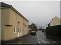
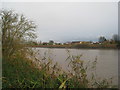
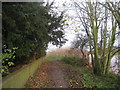
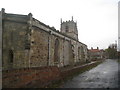
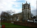
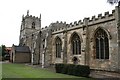
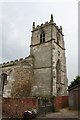
Living in DN17 3LZ means being part of a small, tightly knit residential cluster in North Lincolnshire. The area covers 3,087 square metres and has a population of 1,466, giving it a low density of 165 people per square kilometre. This postcode area is part of the village of Burringham, a civil parish with historical roots and a community-focused character. The median age here is 47, with most residents falling between 30 and 64 years old, suggesting a mature, stable population. Daily life is shaped by proximity to the River Trent and the B1450 road, with access to nearby Scunthorpe’s commercial hubs. A Grade II listed church, the Church of St John the Baptist, and a statue of Lady Claire Linton by the river add to the area’s charm. Homes here are predominantly owner-occupied, with 80% of properties in private hands, and the accommodation is largely houses rather than flats. For those seeking a quiet, family-oriented environment with historical and natural features, DN17 3LZ offers a distinct blend of residential comfort and local heritage.
- Area Type
- Postcode
- Area Size
- 3087 m²
- Population
- 1466
- Population Density
- 165 people/km²
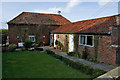
The property market in DN17 3LZ is characterised by high home ownership and a focus on houses. With 80% of properties owned by residents, this is not a rental-heavy area, and the accommodation types are predominantly houses rather than flats. The small size of the postcode area—just 3,087 square metres—means the housing stock is limited, with fewer properties available compared to larger urban areas. This scarcity could make the market competitive for buyers. The presence of a 77-acre development property listed for sale suggests potential for new builds or conversions, though this is not part of the existing residential stock. For buyers, the area’s small size means limited scope for expansion, but the existing houses offer a traditional, family-friendly layout. Those considering DN17 3LZ should factor in the limited number of properties and the need to balance proximity to amenities like Scunthorpe’s commercial centres with the village’s quieter, more secluded character.
House Prices in DN17 3LZ
Showing 6 properties
| Address | Type | Beds | Baths | Last Sale Price | Last Sale Date | |
|---|---|---|---|---|---|---|
| 4 Trent View, Burringham, DN17 3LZ | Terraced | 3 | 1 | £56,000 | May 2024 | |
| 5 Trent View, Burringham, DN17 3LZ | Terraced | 2 | 1 | £110,000 | Jun 2022 | |
| 1 Trent View, Burringham, DN17 3LZ | Terraced | 3 | 1 | £68,500 | Oct 2003 | |
| 3 Trent View, Burringham, DN17 3LZ | Terraced | 3 | 1 | - | - | |
| 2 Trent View, Burringham, DN17 3LZ | Terraced | - | - | - | - | |
| 6 Trent View, Burringham, DN17 3LZ | Terraced | - | - | - | - |
Energy Efficiency in DN17 3LZ
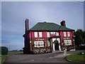
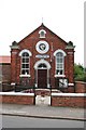
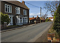
The lifestyle in DN17 3LZ is shaped by its proximity to small-scale amenities and historical landmarks. The village includes a public house, Take a Gander, located on the High Street, offering a local hub for socialising. The Church of St John the Baptist, a Grade II listed building, adds to the area’s heritage, while a statue of Lady Claire Linton by the river bank commemorates local history. Retail options nearby include Tesco Scunthorpe, M&S Scunthorpe RP, and Aldi Gallagher, providing access to essential shopping. The area’s location near the River Trent and the B1450 road offers a mix of natural and practical connectivity. While the village itself is small, residents can access Scunthorpe’s larger commercial centre for more extensive services. This blend of quiet village life and nearby urban convenience defines the daily experience for those living in DN17 3LZ.
Amenities
Schools
The nearest school to DN17 3LZ is Gunness and Burringham Church of England Primary School, a primary school with an Ofsted rating of “good.” This institution serves the local community, providing education for children in the area. As the only school listed in the data, it is the primary option for families in DN17 3LZ. The school’s “good” rating indicates it meets national standards for teaching quality and student outcomes. However, parents seeking secondary education or additional schools may need to look beyond the immediate area, as no other schools are mentioned in the data. The presence of a primary school with a solid rating is a key consideration for families, offering a foundation for early education within the village.
| Rank | School | Type | Entry gender | Ages |
|---|
Explore more schools in this area
Go to Schools tabDemographics
The community in DN17 3LZ is defined by its age profile and home ownership. With a median age of 47 and the most common age range being 30–64 years, the area is home to a predominantly middle-aged and older adult population. Home ownership is high, with 80% of residents owning their homes, reflecting a stable, long-term presence in the area. The accommodation is largely houses, not flats, which aligns with the village’s character. The predominant ethnic group is White, though no further breakdown of diversity is provided. The low population density of 165 people per square kilometre suggests a spread-out, less crowded environment. This demographic profile indicates a community focused on family living and long-term residency, with limited turnover. The age range and home ownership figures suggest a population that is likely to be retired or in later career stages, with fewer young families compared to other areas.
Household Size
Accommodation Type
Tenure
Ethnic Group
Religion
Household Composition
Age
Household Deprivation
NS-SEC
Explore more demographic insights in this area
Go to Demographics tabPlanning
Planning Constraints
- Flood RiskPremium
- Ramsar Wetland SitesPremium
- Area of Outstanding Natural BeautyPremium
- Protected Nature ReservePremium
- Protected WoodlandPremium