Area Overview for DN17 2NA
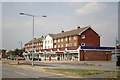
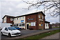
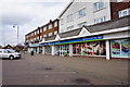
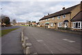
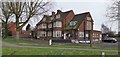
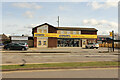
Photos of DN17 2NA


Area Information
DN17 2NA is a small, tightly packed residential cluster in Scunthorpe, North Lincolnshire, covering just 1.8 hectares. With a population of 1,593 and a density of 89,057 people per square kilometre, it is a compact area where proximity to neighbours is inevitable. Situated within the Brumby Ward, it falls under the Scunthorpe parliamentary constituency and is served by nearby rail links. The area’s character is defined by its modest scale and the presence of essential services within walking or short driving distance. While not a sprawling suburb, its density fosters a sense of community, though space is limited. The postcode has been in use since 1980, and its residents are predominantly adults aged 30–64, with a median age of 47. This suggests a mature, settled population, many of whom own their homes. Daily life here revolves around local shops, rail stations, and the practical necessities of a small town. For buyers, the area offers a snapshot of North Lincolnshire’s residential fabric: functional, modest, and deeply rooted in its geography.
- Area Type
- Postcode
- Area Size
- 1.8 hectares
- Population
- 1593
- Population Density
- 4386 people/km²
DN17 2NA is predominantly an owner-occupied area, with 63% of residents owning their homes. The accommodation type is primarily houses, which is unusual for a small postcode area but may reflect the region’s traditional housing stock. This suggests a market skewed towards private ownership rather than rental properties, though the small size of the area limits the availability of diverse housing options. Buyers should expect a focus on single-family homes, which may appeal to those seeking stability or families. However, the compact nature of the area means limited scope for new developments or alternative property types. The high home ownership rate also implies a relatively stable market, but potential buyers must consider the area’s size when assessing long-term value. For those seeking rentals, the data does not indicate a strong presence of rental properties, which could be a consideration for investors.
House Prices in DN17 2NA
Showing 44 properties
| Address | Type | Beds | Baths | Last Sale Price | Last Sale Date | |
|---|---|---|---|---|---|---|
| 42 Angerstein Road, Scunthorpe, DN17 2NA | Semi-detached | 3 | 1 | £65,500 | Aug 2024 | |
| 102 Angerstein Road, Scunthorpe, DN17 2NA | Semi-detached | 3 | 1 | £124,500 | Jan 2024 | |
| 106 Angerstein Road, Scunthorpe, DN17 2NA | Semi-detached | 3 | 1 | £117,000 | Nov 2023 | |
| 98 Angerstein Road, Scunthorpe, DN17 2NA | Semi-detached | 3 | 1 | £145,000 | Feb 2023 | |
| 58 Angerstein Road, Scunthorpe, DN17 2NA | Terraced | 3 | - | £63,000 | Sep 2022 | |
| 24 Angerstein Road, Scunthorpe, DN17 2NA | Semi-detached | 3 | 1 | £116,000 | Nov 2021 | |
| 38 Angerstein Road, Scunthorpe, DN17 2NA | Semi-detached | 3 | - | £86,500 | Apr 2019 | |
| 86 Angerstein Road, Scunthorpe, DN17 2NA | Semi-detached | 3 | 1 | £76,500 | Apr 2019 | |
| 70 Angerstein Road, Scunthorpe, DN17 2NA | Semi-detached | 3 | 1 | £72,000 | Jul 2018 | |
| 26 Angerstein Road, Scunthorpe, DN17 2NA | house | - | - | £50,000 | Jan 2016 |
Energy Efficiency in DN17 2NA
Residents of DN17 2NA have access to essential retail and transport hubs within practical reach. The Lincolnshire Co-operative Co, Heron Riddings, and Tesco Ashby provide nearby shopping options, covering daily needs from groceries to general goods. These stores are likely to be the primary retail outlets for the area, reflecting a practical, no-frills approach to consumer services. The presence of three rail stations—Scunthorpe, Althorpe, and Kirton Lindsey—offers direct connections to larger towns, enhancing the area’s accessibility. While the data does not mention parks or leisure facilities, the compact nature of the area suggests that recreational spaces are limited to nearby public areas or green belts beyond the postcode. The lifestyle here is defined by convenience and proximity: essential services are close, but the area’s small size means residents must rely on nearby towns for more extensive amenities. This balance of practicality and limited space shapes a lifestyle focused on efficiency rather than leisure.
Amenities
Schools
| Rank | School | Type | Entry gender | Ages |
|---|
Explore more schools in this area
Go to Schools tabDemographics
The population of DN17 2NA is 1,593, with a median age of 47, indicating a mature demographic. The most common age range is adults aged 30–64, reflecting a community of established residents rather than a transient population. Home ownership stands at 63%, with houses being the predominant type of accommodation. This suggests a stable, long-term resident base, though the area’s small size means limited property diversity. The predominant ethnic group is White, aligning with broader North Lincolnshire trends. The high population density—89,057 people per square kilometre—implies a compact, possibly high-pressure living environment, though the area’s small footprint mitigates overcrowding. For buyers, this density may translate to a tight-knit community but also limited space for expansion. The data does not indicate significant deprivation, but the high ownership rate and mature age profile suggest a focus on long-term residency rather than investment or rental markets.
Household Size
Accommodation Type
Tenure
Ethnic Group
Religion
Household Composition
Age
Household Deprivation
NS-SEC
Explore more demographic insights in this area
Go to Demographics tabPlanning
Planning Constraints
- Flood RiskPremium
- Ramsar Wetland SitesPremium
- Area of Outstanding Natural BeautyPremium
- Protected Nature ReservePremium
- Protected WoodlandPremium