Area Overview for DN17 2ER
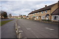
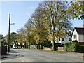
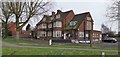
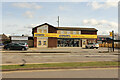
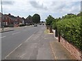
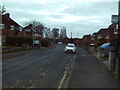
Photos of DN17 2ER


Area Information
DN17 2ER is a small residential postcode area in North Lincolnshire, England, covering 6,260 square metres and home to 1,433 residents. Its high population density of 228,916 people per square kilometre reflects a compact, closely knit community. Situated within the Brumby Ward, this area falls under the Scunthorpe parliamentary constituency and is near key infrastructure like Scunthorpe Railway Station. The demographic profile shows a mature population, with a median age of 47 and most residents aged 30–64. Daily life here is shaped by proximity to retail hubs such as Asda Scunthorpe and Lincolnshire Co-operative Co, while the absence of environmental constraints like flood risks or protected natural sites makes it a practical choice for families and professionals. The area’s broadband score of 100 ensures seamless connectivity, supporting remote work and digital lifestyles. Though small, DN17 2ER offers a balance of accessibility and quiet living, with rail links to nearby towns and a community that leans heavily on local amenities. Its compact size means residents are likely to know their neighbours, creating a distinct character that blends practicality with a sense of cohesion.
- Area Type
- Postcode
- Area Size
- 6260 m²
- Population
- 1433
- Population Density
- 3466 people/km²
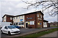
The property market in DN17 2ER is defined by a 45% home ownership rate, with houses making up the majority of accommodation types. This indicates a market where owner-occupation coexists with rental properties, though the exact proportion of rentals is not specified. The area’s small size and high population density suggest a limited housing stock, which may drive competition among buyers. Given the prevalence of houses, the market likely appeals to families or individuals seeking single-family homes rather than apartments. However, the lack of detailed data on property prices or availability means the market’s dynamics remain opaque. For buyers, the compact nature of DN17 2ER means proximity to amenities like Scunthorpe Railway Station and retail outlets is a key selling point, though the area’s size may limit options for larger homes or developments. The absence of environmental constraints like protected woodlands or flood risks could also make it attractive for investors seeking stable, low-risk properties.
House Prices in DN17 2ER
Showing 14 properties
| Address | Type | Beds | Baths | Last Sale Price | Last Sale Date | |
|---|---|---|---|---|---|---|
| 88 Ferriby Road, Scunthorpe, DN17 2ER | house | - | - | £28,500 | Jun 1996 | |
| 86 Ferriby Road, Scunthorpe, DN17 2ER | house | - | - | £27,550 | Mar 1996 | |
| 96 Ferriby Road, Scunthorpe, DN17 2ER | house | - | - | - | - | |
| 90 Ferriby Road, Scunthorpe, DN17 2ER | house | - | - | - | - | |
| 100 Ferriby Road, Scunthorpe, DN17 2ER | house | - | - | - | - | |
| 94 Ferriby Road, Scunthorpe, DN17 2ER | Semi-detached | - | - | - | - | |
| 106 Ferriby Road, Scunthorpe, DN17 2ER | house | - | - | - | - | |
| 102 Ferriby Road, Scunthorpe, DN17 2ER | house | - | - | - | - | |
| 92 Ferriby Road, Scunthorpe, DN17 2ER | house | - | - | - | - | |
| 108 Ferriby Road, Scunthorpe, DN17 2ER | house | - | - | - | - |
Energy Efficiency in DN17 2ER
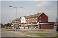
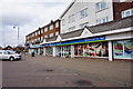
Living in DN17 2ER offers access to a range of local amenities within practical reach. The area is served by five retail outlets, including Lincolnshire Co-operative Co and Asda Scunthorpe, providing essential shopping and dining options. These venues cater to daily needs, from groceries to convenience services, reducing the need for long commutes. While specific parks or leisure facilities are not detailed in the data, the proximity to Scunthorpe suggests access to larger recreational areas, sports facilities, and cultural attractions in the surrounding town. The compact nature of the area means residents can easily walk or cycle to nearby shops, though the absence of detailed information on green spaces or community hubs leaves some lifestyle aspects unexplored. The presence of rail links and retail diversity enhances convenience, making DN17 2ER a practical choice for those valuing accessibility over expansive leisure options.
Amenities
Schools
| Rank | School | Type | Entry gender | Ages |
|---|
Explore more schools in this area
Go to Schools tabDemographics
The community in DN17 2ER is predominantly composed of adults aged 30–64, with a median age of 47. This suggests a population skewed towards middle-aged individuals, likely including professionals, retirees, and families. Home ownership rates stand at 45%, indicating a mix of owner-occupied properties and rental homes. The area is characterised by houses as the primary accommodation type, reflecting a preference for single-family dwellings over flats. The predominant ethnic group is White, with no specific data provided on other demographics. The high population density of 228,916 people per square kilometre implies a compact, densely populated environment, which may influence social dynamics and local services. While the data does not specify deprivation levels, the combination of high density and limited green spaces could impact quality of life for some residents. The age profile suggests a stable, possibly established community with a focus on long-term residency rather than transient populations.
Household Size
Accommodation Type
Tenure
Ethnic Group
Religion
Household Composition
Age
Household Deprivation
NS-SEC
Explore more demographic insights in this area
Go to Demographics tabPlanning
Planning Constraints
- Flood RiskPremium
- Ramsar Wetland SitesPremium
- Area of Outstanding Natural BeautyPremium
- Protected Nature ReservePremium
- Protected WoodlandPremium