Area Overview for DN15 5QW
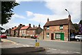
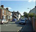
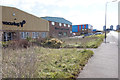
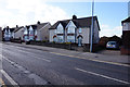
Photos of DN15 5QW


Area Information
Living in DN15 5QW means being part of a small, tightly knit residential cluster in England, home to 1,765 residents. This postcode area is characterised by its compact size and practical layout, offering a quiet alternative to larger urban centres. The community is predominantly composed of adults aged 30–64, with a median age of 47, suggesting a stable population of middle-aged residents. Daily life here is shaped by proximity to essential services, including two railway stations and a selection of retail outlets. While the area lacks the vibrancy of a bustling city, its simplicity and ease of access to nearby towns make it appealing for those prioritising convenience over urban amenities. The absence of protected natural sites or flood risks adds to its practicality, though the high crime risk requires attention. For buyers seeking a low-maintenance lifestyle with straightforward connectivity, DN15 5QW offers a straightforward, no-frills option.
- Area Type
- Postcode
- Area Size
- Not available
- Population
- 1765
- Population Density
- 1943 people/km²
The property market in DN15 5QW is defined by a 30% home ownership rate, indicating that most residents rent their homes. The accommodation type is primarily houses, which are more common than flats or apartments in this area. This suggests a housing stock that caters to families or individuals seeking private, standalone properties. The relatively low home ownership rate may reflect a reliance on rental properties, possibly attracting investors or tenants looking for long-term stability. Given the small size of the area, the housing stock is limited, which could mean competition for available properties. Buyers should consider the practicality of owning in a region where rental options dominate, and the character of the homes may lean towards traditional or semi-detached styles.
House Prices in DN15 5QW
No properties found in this postcode.
Energy Efficiency in DN15 5QW
Residents of DN15 5QW have access to essential retail amenities within practical reach, including Farmfoods Scunthorpe, Aldi Scunthorpe, and Lidl Central. These stores provide basic grocery and household needs, though the selection is limited compared to larger urban centres. The area’s proximity to two railway stations—Scunthorpe and Althorpe—enhances mobility, connecting residents to broader networks for work, shopping, and leisure. While there are no named parks or recreational spaces in the data, the absence of environmental constraints like protected woodlands or wetlands suggests open spaces may be available nearby. The lifestyle here is straightforward, centred on practicality and accessibility rather than luxury or cultural amenities.
Amenities
Schools
| Rank | School | Type | Entry gender | Ages |
|---|
Explore more schools in this area
Go to Schools tabDemographics
The population of DN15 5QW is 1,765, with a median age of 47. The majority of residents fall within the 30–64 age range, indicating a community of working-age adults and older professionals. Home ownership is relatively low at 30%, suggesting that a significant portion of the housing stock is rented out. The predominant accommodation type is houses, reflecting a more traditional residential setup compared to high-density areas. The predominant ethnic group is White, and no specific data on diversity or deprivation is provided. This demographic profile points to a mature, stable population with a focus on practical living. The absence of detailed diversity metrics means the area’s cultural composition remains largely unexplored in official data.
Household Size
Accommodation Type
Tenure
Ethnic Group
Religion
Household Composition
Age
Household Deprivation
NS-SEC
Explore more demographic insights in this area
Go to Demographics tabPlanning
Planning Constraints
- Flood RiskPremium
- Ramsar Wetland SitesPremium
- Area of Outstanding Natural BeautyPremium
- Protected Nature ReservePremium
- Protected WoodlandPremium