Area Overview for DN14 0NR
Photos of DN14 0NR


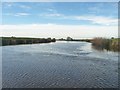
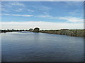
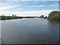
![The River Aire, heading west [upstream] in DN14 0NR](https://images.propbar.co.uk/images/geograph/47/29/4729322_120.jpg)

28 photos from this area
Area Information
Key information about the DN14 0NR including its size, population, and administrative classification.
- Area Type
- Postcode
- Area Size
- 9687 m²
- Population
- 1770
- Population Density
- 249 people/km²
House Prices in DN14 0NR
16
Properties
£181,438
Average Sold Price
£53,000
Lowest Price
£270,000
Highest Price
Showing 16 properties
| Address | Type | Beds | Baths | Last Sale Price | Last Sale Date | |
|---|---|---|---|---|---|---|
| 10 Bird Lane, Kellington, DN14 0NR | Bungalow | 3 | 1 | £270,000 | Jan 2023 | |
| 3 Bird Lane, Kellington, DN14 0NR | Semi-detached | 3 | 1 | £180,000 | Sep 2021 | |
| Briar Lea, 8 Bird Lane, Kellington, DN14 0NR | Bungalow | 3 | 1 | £222,500 | May 2021 | |
| 7 Bird Lane, Kellington, DN14 0NR | house | - | - | £128,000 | Nov 2012 | |
| Brookfield, 6 Bird Lane, Kellington, DN14 0NR | Detached | - | - | £210,000 | Nov 2006 | |
| The Rowans, 4 Bird Lane, Kellington, DN14 0NR | Bungalow | - | - | £240,000 | Oct 2006 | |
| 17 Bird Lane, Kellington, DN14 0NR | Detached | - | - | £148,000 | Feb 2004 | |
| 9 Bird Lane, Kellington, DN14 0NR | Semi-detached | - | - | £53,000 | Jan 1997 | |
| 1 Bird Lane, Kellington, DN14 0NR | house | - | - | - | - | |
| 15 Bird Lane, Kellington, DN14 0NR | Semi-detached | - | - | - | - |
Page 1 of 2
Energy Efficiency in DN14 0NR
Amenities
Schools
| Rank | School | Type | Entry gender | Ages |
|---|
Explore more schools in this area
Go to Schools tabDemographics
Household Size
Two person
most common
Accommodation Type
Houses
most common
Tenure
71
majority
Ethnic Group
White
most common
Religion
N/A
most common
Household Composition
N/A
most common
Age
47
median
Adults (30-64 years)
most common
Household Deprivation
N/A
with no deprivation
NS-SEC
27
in Lower managerial occupations
Explore more demographic insights in this area
Go to Demographics tabPlanning
Planning Constraints
- Flood RiskPremium
- Ramsar Wetland SitesPremium
- Area of Outstanding Natural BeautyPremium
- Protected Nature ReservePremium
- Protected WoodlandPremium