Area Overview for DL8 4YX
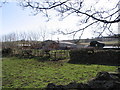
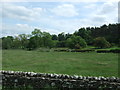
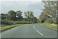
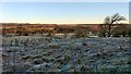
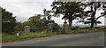
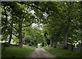
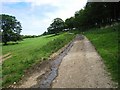
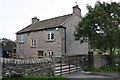
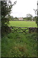
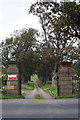
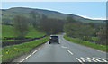
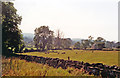
Photos of DL8 4YX
Area Information
DL8 4YX is a small, residential postcode area in England, home to just 1,054 people spread across a low-density landscape. With only 8 people per square kilometre, the area feels spacious and uncluttered, offering a quiet, rural character. The community is predominantly composed of adults aged 30–64, with a median age of 47, suggesting a mature, stable population. Most residents own their homes, with 72% of properties being owner-occupied, and the accommodation is largely houses rather than flats. The area’s small size and sparse population mean it is not a bustling urban hub but a peaceful, low-traffic environment. For those seeking a tranquil, community-focused lifestyle, DL8 4YX provides a simple, unpretentious backdrop. Its proximity to nearby amenities like Co-op Leyburn and metro stations at Redmire and Leyburn ensures practical access to daily needs without the congestion of larger towns. This is a place for those prioritising space, safety, and a slower pace of life.
- Area Type
- Postcode
- Area Size
- Not available
- Population
- 1054
- Population Density
- 8 people/km²
DL8 4YX is a predominantly owner-occupied area, with 72% of properties in private hands. The housing stock is largely composed of houses rather than flats, reflecting the area’s rural and low-density nature. This suggests a market geared towards families or individuals seeking spacious, standalone homes rather than rental properties. The small size of the area means the housing stock is limited, which could result in fewer options for buyers but potentially more established properties. Given the high home ownership rate, the local property market is likely stable, with little pressure from renters. For buyers, this means a focus on purchasing rather than renting, and the availability of houses may appeal to those prioritising space and privacy. The lack of high-density housing also implies a quieter, more secluded environment, which could be a key selling point for those seeking a peaceful lifestyle.
House Prices in DL8 4YX
No properties found in this postcode.
Energy Efficiency in DL8 4YX
The lifestyle in DL8 4YX is defined by simplicity and practicality. The nearest amenities include Co-op Leyburn, a local retail outlet providing basic shopping needs, and two metro stations at Redmire and Leyburn, offering access to public transport. The area’s small size means these facilities are within practical reach, though the range of options is limited. Residents can enjoy a quiet, low-traffic environment with minimal urban pressures, ideal for those seeking a relaxed pace of life. The presence of a primary school and nearby transport links suggests the area caters to families, though the lack of additional amenities like parks or leisure facilities may require travel for more varied activities. The character of DL8 4YX is one of convenience for essentials, with a focus on community and accessibility over extensive leisure options.
Amenities
Schools
The nearest school to DL8 4YX is West Burton Church of England Primary School, which serves the local community with a good Ofsted rating. This primary school is the only educational institution listed in the area, meaning families with children will need to consider secondary education options beyond DL8 4YX. The presence of a well-rated primary school is a significant asset for families, offering a reliable foundation for early education. However, the absence of secondary schools nearby may require parents to look to nearby towns for further schooling. For those prioritising proximity to schools, the primary institution’s quality is a positive factor, though the lack of a broader range of educational facilities should be considered.
| Rank | School | Type | Entry gender | Ages |
|---|
Explore more schools in this area
Go to Schools tabDemographics
The population of DL8 4YX is 1,054, with a median age of 47. This indicates a community skewed towards middle-aged and older adults, with the majority of residents falling within the 30–64 age range. Home ownership is high, with 72% of properties owned by their occupants, suggesting a stable, long-term demographic. The accommodation type is primarily houses, which aligns with the area’s rural character and low density. The predominant ethnic group is White, though no specific diversity statistics are provided. The low population density and mature age profile suggest a community focused on established living rather than family expansion. This demographic profile may influence local services, with amenities tailored to the needs of older residents and homeowners. The absence of significant deprivation data means quality of life is likely shaped by the area’s safety, low crime rates, and natural surroundings.
Household Size
Accommodation Type
Tenure
Ethnic Group
Religion
Household Composition
Age
Household Deprivation
NS-SEC
Explore more demographic insights in this area
Go to Demographics tabPlanning
Planning Constraints
- Flood RiskPremium
- Ramsar Wetland SitesPremium
- Area of Outstanding Natural BeautyPremium
- Protected Nature ReservePremium
- Protected WoodlandPremium