Area Overview for Conistone with Kilnsey
Photos of Conistone with Kilnsey

Area Information
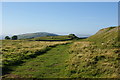
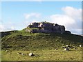
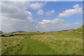
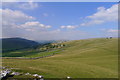
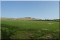
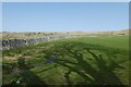
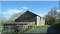
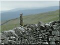
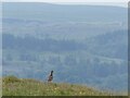
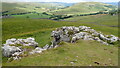
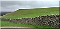
Living in Conistone with Kilnsey means settling into a civil parish that spans 35 square kilometres within the Yorkshire Dales National Park. This rural settlement sits in Upper Wharfedale, specifically positioned on the B6160 road approximately 12 miles north of Skipton. The area combines the villages of Conistone and Kilnsey to form a community defined by limestone scenery and stone-built cottages. You will find yourself in a location where the River Wharfe flows nearby, offering a peaceful atmosphere rather than urban bustle. The parish has ancient roots, with the name Kilnsey deriving from an old term meaning the chilly stream referenced in the Domesday Book. Historical features persist today, from the medieval Kilnsey Old Hall used by Fountains Abbey monks to the standing remains of prehistoric field systems on Conistone Moor. Daily life revolves around natural beauty and walking opportunities, particularly along the Dalesway which serves paths for all standards. Visitors gravitate here for climbing challenges at Kilnsey Crag and the fishing lake at Kilnsey Park. If you seek a location grounded in Yorkshire history with straightforward village access, this parish delivers a clear, authentic rural experience without unnecessary embellishment.
- Area Type
- Parish
- Area Size
- 35.0 km²
- Population
- Not available
- Population Density
- Not available
Demographics
The community in Conistone with Kilnsey reflects a mature and settled population structure. You will find that the median age for residents is 70 years old, indicating a neighbourhood dominated by older generations. This age profile suggests a community where life moves at a deliberate pace, suited to retirement or later living stages rather than bustling young families. Home ownership is exceptionally strong within the parish, with 78 per cent of residents owning their homes outright or with a mortgage. This high ownership rate points to a stable environment where long-term residents have deep roots in the area. The lack of specific data on household composition or predominant ethnic groups suggests a demographic landscape that may require local observation to fully define beyond these hard statistics. You are entering an area where property is largely a family inheritance or a retirement purchase rather than a transient rental market. The high ownership figure of 78 per cent means trading arrangements are often negotiated with someone who knows the land intimately. This demographic reality shapes a quiet, predictable community dynamic where neighbours have likely known each other for decades.
Household Size
Accommodation Type
Tenure
Ethnic Group
Religion
Household Composition
Age
Household Deprivation
NS-SEC
Explore more demographic insights in this area
Go to Demographics tabPlanning
Planning Constraints
- Flood RiskLocked
- Ramsar Wetland SitesLocked
- Protected Nature ReserveLocked
- Protected WoodlandLocked
- Crime RiskLocked