Area Overview for BD9 4JZ
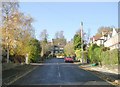
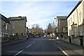
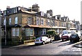
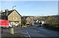
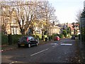
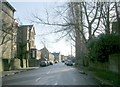
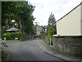
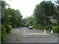
Photos of BD9 4JZ
Area Information
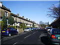
Living in BD9 4JZ means being part of a tightly knit residential cluster in the City of Bradford, where the population of 1,845 is concentrated across 9,002 square metres. This small postcode area, part of the historically significant Heaton Ward, is defined by its Anglo-Saxon roots and 19th-century development. The community is predominantly composed of adults aged 30–64, with a median age of 47, reflecting a mature, stable population. The area’s compact size and high density create a sense of proximity to local amenities, though it remains a quiet, residential hub. Historical features such as St Barnabas Church and Heaton Grove villas hint at its heritage, while modern infrastructure ensures practical living. The mix of family homes and the presence of schools and rail links make it appealing for those seeking a balance between tradition and convenience. For buyers, BD9 4JZ offers a distinct blend of compact living and access to nearby urban resources.
- Area Type
- Postcode
- Area Size
- 9002 m²
- Population
- 1845
- Population Density
- 4283 people/km²
The property market in BD9 4JZ is characterised by a 60% home ownership rate, with houses being the dominant accommodation type. This suggests a residential area primarily occupied by owner-occupiers, likely families seeking stable, long-term housing. The compact size of the postcode area means the housing stock is limited, with no indication of rental properties in the data. Given the high population density, properties are likely to be smaller or multi-generational homes. Buyers should consider the area’s small footprint and proximity to amenities such as schools and rail links. However, the lack of data on property prices or recent developments means the market’s current value and potential for growth remain unclear. For those prioritising ownership in a family-friendly setting, BD9 4JZ offers a focused, if limited, selection of homes.
House Prices in BD9 4JZ
Showing 36 properties
| Address | Type | Beds | Baths | Last Sale Price | Last Sale Date | |
|---|---|---|---|---|---|---|
| 234 Keighley Road, Bradford, BD9 4JZ | house | - | - | £183,000 | Sep 2021 | |
| 238 Keighley Road, Bradford, BD9 4JZ | Terraced | 5 | 1 | £167,000 | Aug 2020 | |
| 252 Keighley Road, Bradford, BD9 4JZ | Terraced | 4 | 2 | £170,000 | Jun 2019 | |
| 258 Keighley Road, Bradford, BD9 4JZ | Semi-detached | 6 | 3 | £308,000 | Jan 2018 | |
| 254 Keighley Road, Bradford, BD9 4JZ | Terraced | - | - | £160,000 | Jul 2016 | |
| 224 Keighley Road, Bradford, BD9 4JZ | house | - | - | £185,000 | Mar 2008 | |
| 214 Keighley Road, Bradford, BD9 4JZ | Flat | 5 | 2 | £28,000 | Aug 2006 | |
| 242 Keighley Road, Bradford, BD9 4JZ | Terraced | - | - | £200,000 | May 2006 | |
| 232 Keighley Road, Bradford, BD9 4JZ | Terraced | - | - | £59,500 | Mar 2000 | |
| 228 Keighley Road, Bradford, BD9 4JZ | house | - | - | £65,500 | Apr 1999 |
Energy Efficiency in BD9 4JZ
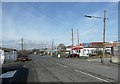
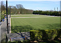
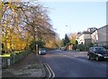
Residents of BD9 4JZ benefit from a range of amenities within practical reach. Retail options include major supermarkets such as Tesco Bradford, Aldi Canal, and Morrisons Daily, ensuring everyday shopping needs are met. The area’s rail stations connect to broader transport networks, with Frizinghall, Shipley, and Bradford Forster Square stations offering access to urban and regional destinations. Nearby airports, including Leeds Bradford Airport, cater to travel requirements. While the data does not specify parks or leisure facilities, the area’s historical conservation status suggests proximity to green spaces or heritage sites. The mix of retail, transport, and travel options supports a convenient lifestyle, though the absence of detailed leisure amenities means further exploration may be needed for those prioritising recreational spaces.
Amenities
Schools
Residents of BD9 4JZ have access to three schools within practical reach. Frizinghall Primary School, a primary school with an Ofsted rating of ‘good’, provides a solid foundation for younger children. Nearby is Frizinghall Middle School, another primary school, though its Ofsted rating is not specified. For specialist education, J.A.M.E.S, a special school, caters to students with specific needs. The presence of two primary schools offers flexibility for families, though the absence of secondary schools means students may need to commute to nearby areas. The ‘good’ rating at Frizinghall Primary suggests a reliable educational option, while J.A.M.E.S highlights the area’s commitment to inclusive education. Parents should assess the suitability of these schools for their children’s needs, particularly if secondary education is required.
| Rank | School | Type | Entry gender | Ages |
|---|
Explore more schools in this area
Go to Schools tabDemographics
BD9 4JZ’s population of 1,845 is skewed toward adults aged 30–64, with a median age of 47. Home ownership stands at 60%, with houses being the primary accommodation type, suggesting a focus on family living. The predominant ethnic group is Asian_total, reflecting the area’s cultural diversity. The population density of 204,949 people per square kilometre is exceptionally high, indicating a tightly packed community. This density may influence social dynamics, fostering a close-knit environment but also potentially limiting private space. The age profile suggests a stable demographic, with fewer young children or retirees, which could affect local services and amenities. The high ownership rate implies long-term residency, though the exact proportion of renters is not specified. These factors collectively shape a community that is both cohesive and diverse, with needs centered on family-oriented living and accessible services.
Household Size
Accommodation Type
Tenure
Ethnic Group
Religion
Household Composition
Age
Household Deprivation
NS-SEC
Explore more demographic insights in this area
Go to Demographics tabPlanning
Planning Constraints
- Flood RiskPremium
- Ramsar Wetland SitesPremium
- Area of Outstanding Natural BeautyPremium
- Protected Nature ReservePremium
- Protected WoodlandPremium