Area Overview for BD8 7LJ
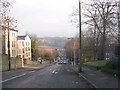
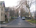
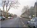
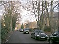
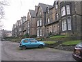
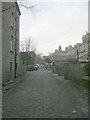
Photos of BD8 7LJ


Area Information
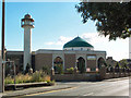
Living in BD8 7LJ provides residences within Manningham, a historic council ward in Bradford, West Yorkshire. This postcode covers a small residential cluster that is part of a ward with approximately 2,285 residents. The area historically functioned as an independent township before becoming integrated into Bradford in 1847. You will find homes set within an environment that retains evidence of earlier rural origins while displaying significant Victorian-era development. The neighbourhood held particular significance as the old Jewish area of Bradford, with settlers arriving in the 1820s and 1830s. German community members later migrated to the nearby Heaton area, contributing to the location's diverse character. British architect and industrialist Samuel Cunliffe Lister financed much of the local infrastructure, including funding the construction of a school in 1832. The area contains 76 listed buildings recorded in the National Heritage List for England, with one holding Grade II* status. Manningham Mills, built in 1838, stands as a significant industrial landmark alongside imposing wool merchants' houses and back-to-back terraced houses. Today, the locality shows signs of cultural regeneration, yet it remains grounded in its industrial past. The streets feature distinctive architecture ranging from mill buildings to the round wards of Bradford Children's Hospital on St Mary's Road.
- Area Type
- Postcode
- Area Size
- Not available
- Population
- 2103
- Population Density
- 4846 people/km²
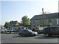
Homes in BD8 7LJ are characteristically houses rather than flats or high-density apartments. The property stock reflects the area's history as a Victorian residential development zone following the opening of Manningham railway station circa 1860. Because only 33 per cent of residents are home owners, the market contains a substantial number of rental properties. This unique blend of ownership suggests a competitive area where entrepreneurs and young professionals often rent before moving into purchase later. You should expect to find a variety of housing tenures including large Victorian terraced houses, converted mill buildings, and smaller back-to-back structures. The prevalence of house ownership over flats distinguishes this cluster from the city centre urban core. Properties here offer more square footage and traditional suburban features despite their location in an industrial heartland. The 76 listed buildings within the conservation area influence the architectural quality, ensuring that a large portion of the local housing stock maintains high historic standards. One Grade II* listed building anchors the area's prestige, though most properties remain unlisted private residences. Buyers looking at this small postcode will find a market defined by character homes rather than modern new builds.
House Prices in BD8 7LJ
No properties found in this postcode.
Energy Efficiency in BD8 7LJ
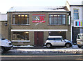
Living in BD8 7LJ places you within practical reach of five retail outlets managed by major chains. You can shop at Tesco Manninghm, Tesco Bradford, and Iceland Manningham for all your weekly groceries and household essentials. These stores offer convenient access to fresh produce, groceries, and daily sundries without requiring a long journey beyond the local cluster. For rail travel, the area enjoys proximity to five railway stations serving the wider network. Bradford Forster Square Railway Station and Bradford Foster Square Railway Station provide regional connections, while Frizinghall Railway Station offers another nearby interchange point. A short distance away lies Leeds Bradford Airport and Leeds Bradford International Airport, offering two points of international departure for travel needs. These amenities combine to create a neighbourhood where daily shopping and weekly travel are equally efficient. The presence of these major transport hubs close to your doorstep means commuting to the city or flying abroad involves minimal transit time. Shops named Tesco Manninghm and Iceland Manningham form the commercial core for residents walking from their houses in the postcode.
Amenities
Schools
Families considering BD8 7LJ have access to St Paul's First School, which operates as a primary institution within the immediate locality. This school serves the immediate residential needs of children living in the cluster. In addition to the state sector option, you will find the Islamic Tarbiyyah Preparatory School nearby. This institution operates as an independent school offering an alternative education pathway for families who prefer private tuition. The proximity of St Paul's First School supports those seeking state education within walking distance of their homes in BD8 7LJ. The independent sector represented by Islamic Tarbiyyah Preparatory School provides options for parents seeking different academic environments or smaller class sizes. Note that the Islamic Tarbiyyah Preparatory School carries an Ofsted rating of inadequate. This specific assessment indicates that the independent school currently requires significant improvement in its educational standards. When evaluating schools near BD8 7LJ, you must weigh the stability of the state primary option against the risks associated with the independent provider's current performance.
| Rank | School | Type | Entry gender | Ages |
|---|
Explore more schools in this area
Go to Schools tabDemographics
The community in this postcode area consists largely of adults between 30 and 64 years old. The median age for residents is 47 years, making it an area dominated by middle-aged adults rather than young families or the elderly. Regarding housing tenure, 33 per cent of residents own their homes outright or with a mortgage. The remaining households predominantly rent, indicating a significant private or sector rental component within the local market. The primary accommodation type found here is houses, meaning you will encounter detached, semi-detached, and terraced properties rather than flats or bungalows. Diversity within the cluster is notable, with the Asian ethnic group forming the predominant demographic. This reflects the broader historical settlement patterns of the area which served as a historic workers' quarter. You are likely to meet a population with deep local roots connected to the textile industry, alongside more recent migrants who have joined the growing community. The age structure suggests a stable neighbourhood where long-term residents often place their children through the local school system before the family unit eventually moves. This demographic stability contributes to a consistent community feel despite the historical industrial fluctuations the ward has experienced over centuries.
Household Size
Accommodation Type
Tenure
Ethnic Group
Religion
Household Composition
Age
Household Deprivation
NS-SEC
Explore more demographic insights in this area
Go to Demographics tabPlanning
Planning Constraints
- Flood RiskPremium
- Ramsar Wetland SitesPremium
- Area of Outstanding Natural BeautyPremium
- Protected Nature ReservePremium
- Protected WoodlandPremium