Area Overview for BD7 4JN
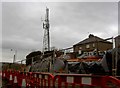
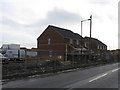
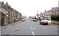
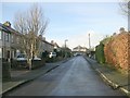
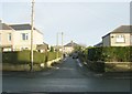
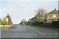
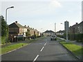
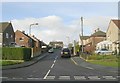
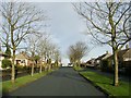
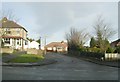
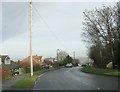
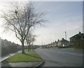
Photos of BD7 4JN
Area Information
Living in BD7 4JN means being part of a tightly knit residential cluster in the City of Bradford, West Yorkshire. This small postcode area, covering 5,882 square metres, is home to 1,469 people, making it one of the most densely populated places in England, with over 249,729 people per square kilometre. Despite its compact size, the area is steeped in history, forming part of the Great Horton conservation area. Here, 17th- and 18th-century buildings stand alongside 19th-century workers’ housing, preserving a unique blend of rural heritage and industrial past. Proximity to Bradford city centre—just 2.5 miles away—offers easy access to urban amenities, while the conservation area’s listed buildings, including Hall’s House and Horton Park, provide a sense of continuity with the past. Daily life is shaped by a mix of quiet residential streets and the convenience of nearby retail and transport hubs, making BD7 4JN a compact yet multifaceted place to live.
- Area Type
- Postcode
- Area Size
- 5882 m²
- Population
- 1469
- Population Density
- 7375 people/km²
The property market in BD7 4JN is dominated by owner-occupied homes, with 86% of residents living in houses rather than flats or apartments. This reflects a preference for traditional, family-sized dwellings, typical of the area’s 19th-century workers’ housing and historic buildings. Given the postcode’s small size and conservation status, the housing stock is limited, making it a niche market for buyers seeking character properties. The presence of listed buildings, such as the 1739 King’s Arms and Horton Park, adds value to the area, though property availability is constrained by the small footprint. Buyers should consider the proximity to Bradford’s urban core, which offers access to services and transport, while the conservation area’s restrictions may limit redevelopment potential.
House Prices in BD7 4JN
Showing 15 properties
| Address | Type | Beds | Baths | Last Sale Price | Last Sale Date | |
|---|---|---|---|---|---|---|
| 6 Fairway Drive, Bradford, BD7 4JN | house | - | - | £131,000 | Mar 2022 | |
| 7 Fairway Drive, Bradford, BD7 4JN | Semi-detached | 3 | 1 | £129,000 | Jan 2020 | |
| 11 Fairway Drive, Bradford, BD7 4JN | Semi-detached | 3 | 1 | £165,000 | Aug 2019 | |
| 2 Fairway Drive, Bradford, BD7 4JN | house | - | - | £160,000 | Jun 2016 | |
| 4 Fairway Drive, Bradford, BD7 4JN | Semi-detached | 4 | 2 | £122,500 | Jul 2012 | |
| 10 Fairway Drive, Bradford, BD7 4JN | Semi-detached | 3 | 1 | £127,000 | Sep 2005 | |
| 9 Fairway Drive, Bradford, BD7 4JN | Semi-detached | 3 | 1 | £139,000 | Jun 2005 | |
| 5 Fairway Drive, Bradford, BD7 4JN | Semi-detached | - | - | £78,000 | Feb 2002 | |
| 17 Fairway Drive, Bradford, BD7 4JN | Semi-detached | 3 | 1 | - | - | |
| 1 Fairway Drive, Bradford, BD7 4JN | Semi-detached | - | - | - | - |
Energy Efficiency in BD7 4JN
Life in BD7 4JN is shaped by its proximity to retail, green spaces, and historical sites. Within practical reach are shops like Tesco Bradford, Co-op Wibsey, and Aldi Clayton, offering everyday essentials. The nearby Horton Park, opened in 1878, provides a public space for leisure, with its 19th-century design by William Gay. The conservation area itself is a draw, featuring listed buildings such as Hall’s House and the Old Bell Chapel, adding cultural value to daily life. The mix of historic architecture and modern amenities creates a lifestyle that balances heritage with convenience. Residents can enjoy the tranquillity of preserved rural landscapes while benefiting from easy access to urban services, making BD7 4JN a place where history and practicality coexist.
Amenities
Schools
| Rank | School | Type | Entry gender | Ages |
|---|
Explore more schools in this area
Go to Schools tabDemographics
The community in BD7 4JN is predominantly composed of adults aged 30–64, with a median age of 47. This suggests a mature, stable population, likely with established careers and families. Home ownership is exceptionally high at 86%, indicating a strong preference for long-term residency over rental properties. The area is characterised by houses rather than flats, reflecting a traditional, family-oriented housing stock. The predominant ethnic group is Asian_total, which shapes the cultural fabric of the neighbourhood. This demographic profile aligns with the broader history of Great Horton, where 19th-century industrial growth attracted workers and their families. The high home ownership rate and age range suggest a community with low turnover, where residents are likely to have built long-term ties to the area.
Household Size
Accommodation Type
Tenure
Ethnic Group
Religion
Household Composition
Age
Household Deprivation
NS-SEC
Explore more demographic insights in this area
Go to Demographics tabPlanning
Planning Constraints
- Flood RiskPremium
- Ramsar Wetland SitesPremium
- Area of Outstanding Natural BeautyPremium
- Protected Nature ReservePremium
- Protected WoodlandPremium