Area Overview for BD7 4ED
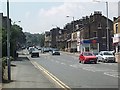
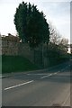
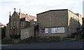
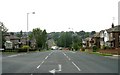
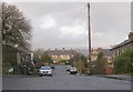
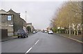
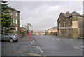
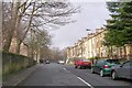
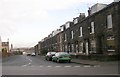
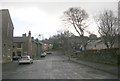
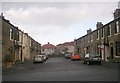
Photos of BD7 4ED

Area Information
Living in BD7 4ED means inhabiting a tightly packed residential cluster within the historic ward of Great Horton, Bradford. This area, covering just 9,982 m², is home to 1,798 people, resulting in a remarkably high population density of 180,127 per km². Despite its small size, BD7 4ED sits within a conservation area that preserves 17th- to 19th-century architecture, including listed buildings like Hall’s House and the Old Bell Chapel. The area’s character blends urban convenience with historic charm, shaped by 19th-century industrial growth and Saxon-era roots. Residents benefit from proximity to Bradford’s city centre, 2.5 miles away, while the ward’s compact nature fosters a sense of community. With a median age of 47 and a population skewed toward adults aged 30–64, this is a mature, established neighbourhood. Its mix of workers’ housing and historic homes reflects a legacy of industrial-era development, now reimagined in a modern context.
- Area Type
- Postcode
- Area Size
- 9982 m²
- Population
- 1798
- Population Density
- 6300 people/km²
The property market in BD7 4ED is characterised by a 40% home ownership rate, with the majority of properties being houses. This suggests a mix of owner-occupied and rental homes, though the limited area size means housing stock is constrained. The prevalence of houses in a high-density postcode is unusual, hinting at a blend of historic, larger properties and more modest homes. For buyers, this small area offers limited scope for expansion, with immediate surroundings likely to dictate availability. The conservation area status may influence property values, preserving historic features but also restricting development. Given the high population density, competition for homes is likely, and the rental market may dominate. Prospective buyers should consider the compact nature of the area and the potential for limited future growth.
House Prices in BD7 4ED
Showing 14 properties
| Address | Type | Beds | Baths | Last Sale Price | Last Sale Date | |
|---|---|---|---|---|---|---|
| 583 Great Horton Road, Bradford, BD7 4ED | Retail | 3 | 1 | £80,000 | Oct 2024 | |
| 585 Great Horton Road, Bradford, BD7 4ED | Cottage | 1 | 1 | £57,500 | Jun 2023 | |
| 609 Great Horton Road, Bradford, BD7 4ED | house | - | - | £60,000 | Nov 2022 | |
| 611 Great Horton Road, Bradford, BD7 4ED | house | - | - | £60,000 | Nov 2022 | |
| 587 Great Horton Road, Bradford, BD7 4ED | house | - | - | £54,500 | Jan 2022 | |
| 579 Great Horton Road, Bradford, BD7 4ED | Terraced | 2 | 1 | £44,000 | Mar 2019 | |
| 581 Great Horton Road, Bradford, BD7 4ED | Terraced | 2 | 1 | £46,000 | Oct 2013 | |
| 589A Great Horton Road, Bradford, BD7 4ED | Flat | - | - | £40,000 | Feb 2007 | |
| 615B Great Horton Road, Bradford, BD7 4ED | Industrial | - | - | - | - | |
| Royal Garage, Workshop, 597 Great Horton Road, Bradford, BD7 4ED | Industrial | - | - | - | - |
Energy Efficiency in BD7 4ED
BD7 4ED’s residents have access to a range of amenities within practical reach. Retail options include Tesco Bradford, Aldi Clayton, and Heron Clayton, providing everyday shopping convenience. The area’s proximity to Horton Park, opened in 1878, offers green space for leisure and outdoor activity. Historic sites like Hall’s House and the Old Bell Chapel add cultural value, while the conservation area’s listed buildings contribute to a unique character. The compact nature of the postcode means amenities are closely clustered, reducing travel time. For dining and socialising, the lack of specific venues in the data suggests reliance on nearby Bradford districts. Overall, the blend of retail, green space, and historic architecture creates a lifestyle that balances urban practicality with preserved heritage.
Amenities
Schools
Nearby schools include Brackenhill Primary School, rated ‘good’ by Ofsted, and St Oswald’s Church of England Primary Academy, which has a ‘satisfactory’ rating. Great Horton Middle School and Ummid Independent School, a special needs institution, also serve the area. The mix of primary and special schools provides options for families, though the absence of secondary schools nearby may require commuting. St Oswald’s CofE Primary School, another local primary, lacks an Ofsted rating in the data. The presence of multiple primary schools suggests a focus on early education, but parents seeking secondary schooling will need to look beyond BD7 4ED. The variation in ratings indicates a range of educational quality, with some schools performing above average and others requiring closer scrutiny.
| Rank | School | Type | Entry gender | Ages |
|---|
Explore more schools in this area
Go to Schools tabDemographics
The population of BD7 4ED is predominantly adults aged 30–64, with a median age of 47. Home ownership here is relatively low at 40%, suggesting a higher proportion of renters compared to owner-occupied properties. The area’s accommodation is largely composed of houses, which is uncommon in densely populated urban zones. The predominant ethnic group is Asian, reflecting broader demographic patterns in Bradford. While specific data on deprivation is absent, the high population density and reliance on rental housing may indicate socioeconomic diversity. The presence of 40% homeownership contrasts with the area’s compact size, suggesting limited scope for property expansion. For families, the age profile implies a stable, middle-aged population, though the lack of data on household composition means further analysis is required to gauge family dynamics.
Household Size
Accommodation Type
Tenure
Ethnic Group
Religion
Household Composition
Age
Household Deprivation
NS-SEC
Explore more demographic insights in this area
Go to Demographics tabPlanning
Planning Constraints
- Flood RiskPremium
- Ramsar Wetland SitesPremium
- Area of Outstanding Natural BeautyPremium
- Protected Nature ReservePremium
- Protected WoodlandPremium