Area Overview for BD7 4DN
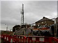
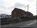
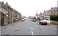
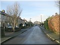
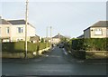
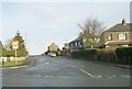
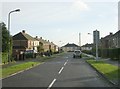
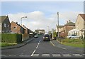
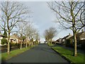
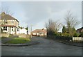
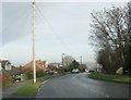
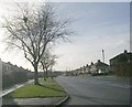
Photos of BD7 4DN
Area Information
BD7 4DN is a small residential postcode area within the historic Great Horton ward of Bradford, West Yorkshire. Covering just 1.4 hectares, it is densely populated, with 1,574 residents living at a density of 113,808 people per square kilometre. This compact area lies approximately 2.5 miles south-west of Bradford city centre, blending urban convenience with preserved historic character. Once a rural settlement of scattered farmsteads, it became part of Bradford’s 19th-century industrial expansion, marked by cotton mills, workers’ housing, and chapels. Today, it is designated a conservation area, safeguarding 17th-19th century buildings like Hall’s House and Horton Park, a public park opened in 1878. The area’s mix of historic architecture and modern infrastructure makes it distinct, offering a compact, walkable community with access to rail links and local amenities. Its proximity to Bradford’s core means residents enjoy city amenities while retaining a sense of historic continuity.
- Area Type
- Postcode
- Area Size
- 1.4 hectares
- Population
- 1574
- Population Density
- 7214 people/km²
BD7 4DN is a predominantly owner-occupied area, with 69% of homes owned by residents rather than rented. The accommodation type is exclusively houses, not flats, suggesting a focus on single-family homes. Given the area’s small size (1.4 hectares) and high population density, the housing stock is likely limited, with properties concentrated in the conservation area’s historic buildings. This mix of 17th-19th century homes and workers’ housing may appeal to buyers seeking characterful properties with historical significance. However, the scarcity of available homes could make the market competitive. Buyers should consider the area’s compact nature, which means proximity to neighbours and limited space for expansion. The conservation status may also impose restrictions on property modifications, adding to the area’s unique appeal but requiring careful planning for renovations.
House Prices in BD7 4DN
Showing 34 properties
| Address | Type | Beds | Baths | Last Sale Price | Last Sale Date | |
|---|---|---|---|---|---|---|
| 45 Pickles Lane, Bradford, BD7 4DN | Terraced | 6 | 2 | £140,000 | Dec 2023 | |
| 58 Pickles Lane, Bradford, BD7 4DN | Semi-detached | 3 | 2 | £250,000 | Oct 2022 | |
| 23 Pickles Lane, Bradford, BD7 4DN | Semi-detached | 3 | 1 | £208,000 | Sep 2022 | |
| 55 Pickles Lane, Bradford, BD7 4DN | Terraced | 3 | 1 | £92,500 | Apr 2022 | |
| 30 Pickles Lane, Bradford, BD7 4DN | Terraced | 4 | 2 | £97,000 | Jan 2022 | |
| 49 Pickles Lane, Bradford, BD7 4DN | house | - | - | £120,000 | Aug 2021 | |
| 54 Pickles Lane, Bradford, BD7 4DN | house | - | - | £355,000 | Jun 2021 | |
| 52 Pickles Lane, Bradford, BD7 4DN | Semi-detached | 4 | 1 | £120,000 | Dec 2019 | |
| 44 Pickles Lane, Bradford, BD7 4DN | Terraced | 2 | 1 | £147,000 | Dec 2019 | |
| 25 Pickles Lane, Bradford, BD7 4DN | Semi-detached | 2 | 1 | £132,000 | Dec 2019 |
Energy Efficiency in BD7 4DN
Living in BD7 4DN offers access to a range of local amenities within practical reach. Retail options include Tesco Bradford, Aldi Clayton, and Heron Clayton, providing everyday shopping needs. The area’s rail links to Bradford Interchange and Forster Square stations make commuting to the city centre or further afield convenient. Nearby, Horton Park—a public park established in 1878—offers green space for leisure and exercise. The conservation area’s listed buildings, such as Hall’s House and the Old Bell Chapel, add historical interest. While the area is small, its mix of retail, transport, and green space creates a functional daily life, blending urban accessibility with preserved heritage. The compact layout ensures amenities are within walking distance, though the high population density may mean limited private outdoor space for residents.
Amenities
Schools
| Rank | School | Type | Entry gender | Ages |
|---|
Explore more schools in this area
Go to Schools tabDemographics
The population of BD7 4DN is predominantly middle-aged, with a median age of 47 and the most common age range being adults aged 30-64. Home ownership is high at 69%, reflecting a community of long-term residents rather than transient renters. The area is primarily composed of houses, not flats, suggesting a focus on family-oriented living. The predominant ethnic group is White, with no specific data on other demographics. The high population density—113,808 people per square kilometre—means the area is intensely populated, with limited space for new development. This density may influence the character of daily life, creating a tightly knit but potentially crowded environment. The age profile indicates a stable, mature community, which may affect local services and amenities tailored to older residents.
Household Size
Accommodation Type
Tenure
Ethnic Group
Religion
Household Composition
Age
Household Deprivation
NS-SEC
Explore more demographic insights in this area
Go to Demographics tabPlanning
Planning Constraints
- Flood RiskPremium
- Ramsar Wetland SitesPremium
- Area of Outstanding Natural BeautyPremium
- Protected Nature ReservePremium
- Protected WoodlandPremium