Area Overview for BD7 4AY
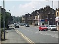
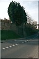
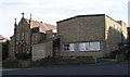
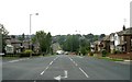
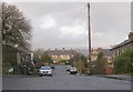
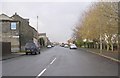
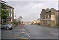
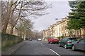
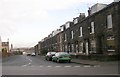
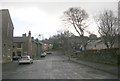
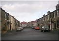
Photos of BD7 4AY

Area Information
Living in BD7 4AY means inhabiting a compact, densely populated residential cluster within the City of Bradford. The area covers just 1.3 hectares, housing 1,715 people in a high-density layout of 131,983 people per square kilometre. This postcode falls within the Great Horton conservation area, a historic district preserving 17th- to 19th-century buildings amid urban growth. The ward’s roots trace back to the Saxon period, with industrial heritage including cotton mills and religious sites like the Moravian Chapel. Today, it blends urban convenience with architectural preservation, offering a quiet yet connected lifestyle. Residents benefit from proximity to Bradford’s city centre, rail networks, and Horton Park, a 1878 public space designed by William Gay. The area’s character is defined by its conservation status, with listed buildings such as Hall’s House and the Old Bell Chapel standing alongside modern amenities. For those seeking a compact, historic neighbourhood with practical access to city services, BD7 4AY provides a distinct blend of heritage and modernity.
- Area Type
- Postcode
- Area Size
- 1.3 hectares
- Population
- 1715
- Population Density
- 2719 people/km²
BD7 4AY is primarily an owner-occupied area, with 64% of homes owned by residents rather than rented. The accommodation type is predominantly houses, which is unusual for a densely populated postcode but aligns with the area’s conservation status and historic layout. This suggests a mix of older, characterful homes and newer builds, though the small area size (1.3 hectares) limits the variety of property types available. The high home ownership rate may indicate a stable market with fewer rental properties, potentially making it challenging for buyers seeking immediate availability. The conservation area designation adds value to properties, but it also imposes planning constraints that could affect renovations or extensions. For buyers, this means a focus on existing homes rather than new developments, with a need to consider the area’s limited size and the character of its historic architecture when evaluating property options.
House Prices in BD7 4AY
Showing 28 properties
| Address | Type | Beds | Baths | Last Sale Price | Last Sale Date | |
|---|---|---|---|---|---|---|
| 101 Hollingwood Lane, Bradford, BD7 4AY | house | - | - | £290,000 | Dec 2024 | |
| 95 Hollingwood Lane, Bradford, BD7 4AY | house | 3 | 1 | £230,000 | Aug 2024 | |
| 326 Hollingwood Lane, Bradford, BD7 4AY | Semi-detached | 2 | 1 | £160,000 | May 2024 | |
| 332 Hollingwood Lane, Bradford, BD7 4AY | house | - | - | £150,000 | Mar 2023 | |
| 103 Hollingwood Lane, Bradford, BD7 4AY | Semi-detached | 5 | 1 | £253,000 | Mar 2023 | |
| 342-344 Hollingwood Lane, Bradford, BD7 4AY | house | 3 | 2 | £167,000 | Feb 2023 | |
| 320 Hollingwood Lane, Bradford, BD7 4AY | Terraced | 2 | 1 | £120,000 | Oct 2022 | |
| 350 Hollingwood Lane, Bradford, BD7 4AY | Bungalow | 3 | 1 | £200,000 | Apr 2022 | |
| 318 Hollingwood Lane, Bradford, BD7 4AY | Terraced | 3 | 2 | £86,500 | Apr 2019 | |
| 328 Hollingwood Lane, Bradford, BD7 4AY | Semi-detached | 2 | 1 | £90,000 | Mar 2019 |
Energy Efficiency in BD7 4AY
Residents of BD7 4AY have access to a range of nearby amenities, including five retail outlets such as Heron Clayton, Aldi Clayton, and Tesco Bradford. These shops provide essential shopping and dining options within practical reach. The area’s proximity to Horton Park, a public space opened in 1878, offers green space for recreation, walking, and relaxation. The conservation area status adds to the local character, with historic buildings like Hall’s House and the Old Bell Chapel contributing to a distinct sense of place. The rail network, with multiple stations nearby, ensures easy access to broader city amenities. While the area is small, its combination of retail, green space, and historic architecture creates a lifestyle that balances practicality with a touch of heritage. The limited size of BD7 4AY means amenities are concentrated, requiring residents to navigate the immediate vicinity for most services.
Amenities
Schools
The nearest school to BD7 4AY is Hollingwood Primary School, a primary education institution serving the area. While the data lists the school twice, it is the only named school provided. The absence of secondary schools or additional primary institutions suggests that families may need to look beyond BD7 4AY for secondary education or additional primary options. The presence of a primary school indicates some local provision for younger children, though the limited number of schools may require commuting for higher education. The data does not include Ofsted ratings or specific performance metrics, so prospective parents should conduct further research into the school’s quality and capacity. For families prioritising proximity to schools, the availability of a primary institution is a practical advantage, but the lack of diversity in educational options may be a consideration.
| Rank | School | Type | Entry gender | Ages |
|---|
Explore more schools in this area
Go to Schools tabDemographics
The population of BD7 4AY is predominantly adults aged 30–64, with a median age of 47. This suggests a mature, stable community with a strong presence of families and professionals. Home ownership is high at 64%, indicating a mix of long-term residents and those invested in the area’s conservation status. The accommodation type is primarily houses, reflecting a residential character distinct from high-density housing. The predominant ethnic group is White, though no specific data on diversity or deprivation levels is provided. The age profile and home ownership rates suggest a community focused on stability, with fewer young families or transient populations. The high proportion of owner-occupied homes may indicate lower rental availability, potentially influencing property market dynamics. The area’s demographic makeup aligns with its historic, low-density layout, where older homes and conservation status shape both lifestyle and housing choices.
Household Size
Accommodation Type
Tenure
Ethnic Group
Religion
Household Composition
Age
Household Deprivation
NS-SEC
Explore more demographic insights in this area
Go to Demographics tabPlanning
Planning Constraints
- Flood RiskPremium
- Ramsar Wetland SitesPremium
- Area of Outstanding Natural BeautyPremium
- Protected Nature ReservePremium
- Protected WoodlandPremium