Area Overview for BD7 3AY
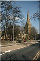
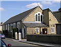
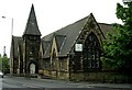
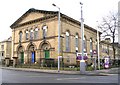
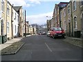
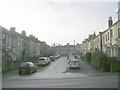
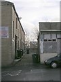
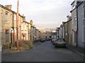
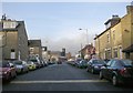
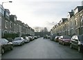
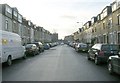
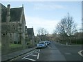
Photos of BD7 3AY
Area Information
Living in BD7 3AY means being part of a tightly knit residential cluster in the heart of Bradford’s city centre. This postcode covers just 1.4 hectares, housing 2051 people in a densely populated area with a population density of 144,956 per square kilometre. The area is defined by its central urban boundaries, falling within the City Ward of Bradford Metropolitan District Council. Daily life here is shaped by proximity to the city’s core, with easy access to rail networks and local amenities. The compact size means residents are close to cultural and historical sites, though the area’s character is defined by its mix of residential and urban infrastructure. With a median age of 22, the population skews younger, but the most common age group is adults aged 30–64, suggesting a blend of families and professionals. The area’s small footprint and high density make it ideal for those seeking a central location without the sprawl of suburban living.
- Area Type
- Postcode
- Area Size
- 1.4 hectares
- Population
- 2051
- Population Density
- 7622 people/km²
The property market in BD7 3AY is characterised by a 40% home ownership rate, with houses being the primary accommodation type. This suggests a mix of owner-occupied and rental properties, though the low ownership rate implies a significant portion of the housing stock is available for rent. Given the area’s small size—just 1.4 hectares—the housing stock is limited, likely comprising terraced or semi-detached homes typical of urban centres. The high population density of 144,956 per square kilometre further indicates compact, possibly older housing. For buyers, this means competition for properties is likely, with limited scope for expansion. The proximity to Bradford’s city centre and rail networks may make the area attractive to professionals or families seeking urban convenience, though the small size means buyers must consider immediate surroundings for additional options.
House Prices in BD7 3AY
Showing 7 properties
| Address | Type | Beds | Baths | Last Sale Price | Last Sale Date | |
|---|---|---|---|---|---|---|
| 21 All Saints Road, Bradford, BD7 3AY | house | - | - | £30,000 | Jan 2013 | |
| 17 All Saints Road, Bradford, BD7 3AY | house | - | - | £65,000 | May 2003 | |
| 19 All Saints Road, Bradford, BD7 3AY | Terraced | - | - | £30,000 | Mar 2003 | |
| 15 All Saints Road, Bradford, BD7 3AY | Terraced | 1 | 1 | £58,000 | Jan 2000 | |
| Flat At, 10 All Saints Road, Bradford, BD7 3AY | Flat | - | - | - | - | |
| Hijaz Community Centre, Workshop At, Former M And M Carpets, All Saints Road, Bradford, BD7 3AY | Industrial | - | - | - | - | |
| Ali Mazhar Accountants, 10 All Saints Road, Bradford, BD7 3AY | Office | - | - | - | - |
Energy Efficiency in BD7 3AY
Residents of BD7 3AY have access to a range of local amenities within walking distance. The area includes five retail outlets, such as Asda Little, Lidl Bankfoot, and Spar Manchester, providing convenience for everyday shopping. These shops cater to basic needs, though the selection is limited to essential services. The proximity to multiple railway stations enhances mobility, allowing easy access to broader urban and regional networks. While the data does not mention parks or leisure facilities, the area’s central location within Bradford suggests nearby cultural and recreational opportunities. The compact size of BD7 3AY means amenities are closely clustered, though the lack of specific details on parks or dining options means residents may need to venture slightly further for a full range of lifestyle choices.
Amenities
Schools
The nearest school to BD7 3AY is Copthorne Primary School, which serves the area’s primary education needs. This school holds an outstanding Ofsted rating, reflecting high standards in teaching and student outcomes. The presence of a single primary school suggests that families in the area rely on this institution for early education, though secondary schooling options would require commuting to nearby districts. The outstanding rating indicates strong academic performance and supportive infrastructure, which is a key consideration for parents prioritising quality education. With no secondary schools listed in the data, families may need to plan for additional travel, but the primary school’s excellence offers a solid foundation for young learners.
| Rank | School | Type | Entry gender | Ages |
|---|
Explore more schools in this area
Go to Schools tabDemographics
BD7 3AY has a median age of 22, but the majority of residents fall within the 30–64 age range, indicating a population skewed toward working-age adults. Home ownership here is relatively low at 40%, with the remaining 60% likely to be renters, reflecting a mix of private and rental housing. The predominant accommodation type is houses, though the high population density suggests these are likely terraced or semi-detached properties. The area’s demographic profile is marked by a strong Asian presence, with this group forming the largest ethnic category. This diversity shapes the community’s cultural fabric, though specific data on deprivation or income levels is not available. The high density and young median age suggest a dynamic, possibly transient population, though the presence of families in the 30–64 age bracket indicates stability for some households.
Household Size
Accommodation Type
Tenure
Ethnic Group
Religion
Household Composition
Age
Household Deprivation
NS-SEC
Explore more demographic insights in this area
Go to Demographics tabPlanning
Planning Constraints
- Flood RiskPremium
- Ramsar Wetland SitesPremium
- Area of Outstanding Natural BeautyPremium
- Protected Nature ReservePremium
- Protected WoodlandPremium