Area Overview for BD7 2SE
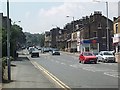
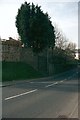
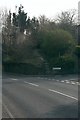
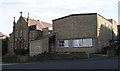
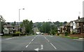
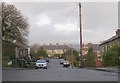
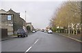
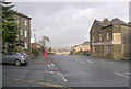
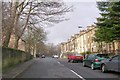
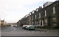
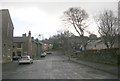
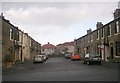
Photos of BD7 2SE
Area Information
BD7 2SE is a small, densely populated postcode area in West Yorkshire, covering just 4,311 square metres and home to 1,483 residents. Its compact size means it functions more like a village than a sprawling suburb, with a population density of 344,039 people per square kilometre. Located in Clayton, a historic parish west of Bradford city centre, the area retains echoes of its Saxon farming roots, with names like “Clayton” deriving from Old English for “farmstead on clay.” Despite its small footprint, it offers a mix of residential clusters and community spaces, including a conservation area centred on Town End. The area’s proximity to Bradford—just 3–3½ miles away—provides easy access to urban amenities while maintaining a distinct rural character. With 78% of homes owner-occupied and a median age of 47, it’s a stable, family-oriented community. Daily life here is shaped by its history, with listed buildings, a 19th-century church, and the village’s famed “wells” serving as a historic meeting spot. The area’s compactness means residents can walk to local shops, schools, and rail links, though its small size also means limited expansion.
- Area Type
- Postcode
- Area Size
- 4311 m²
- Population
- 1483
- Population Density
- 4487 people/km²
The property market in BD7 2SE is dominated by owner-occupied homes, with 78% of properties owned outright. This high rate of home ownership indicates a stable, long-term resident base with little reliance on rental markets. The accommodation type is predominantly houses, which aligns with the area’s rural character and the presence of a conservation area. This suggests a focus on traditional, family-sized homes rather than apartments or flats. Given the postcode’s small size—just 4,311 square metres—the housing stock is limited, meaning the market is likely competitive for buyers. The high home ownership rate also implies that properties may retain value over time, though the compact nature of the area means limited scope for new developments. For buyers, this means a focus on existing homes with potential for renovation or adaptation, rather than speculative investment in new builds. The area’s proximity to Bradford also makes it a draw for commuters seeking a quieter, historic setting.
House Prices in BD7 2SE
Showing 8 properties
| Address | Type | Beds | Baths | Last Sale Price | Last Sale Date | |
|---|---|---|---|---|---|---|
| 210 Pasture Lane, Bradford, BD7 2SE | Semi-detached | - | - | £150,000 | Aug 2015 | |
| 192 Pasture Lane, Bradford, BD7 2SE | house | - | - | £105,000 | Oct 2013 | |
| 202 Pasture Lane, Bradford, BD7 2SE | Office | - | - | £142,500 | Sep 2009 | |
| 194 Pasture Lane, Bradford, BD7 2SE | Semi-detached | 3 | - | £94,500 | Jun 2009 | |
| 196 Pasture Lane, Bradford, BD7 2SE | house | - | - | £119,950 | Oct 2006 | |
| 204 Pasture Lane, Bradford, BD7 2SE | Detached | - | - | - | - | |
| 210A Pasture Lane, Bradford, BD7 2SE | Semi-detached | - | - | - | - | |
| 198 Pasture Lane, Bradford, BD7 2SE | Semi-detached | - | - | - | - |
Energy Efficiency in BD7 2SE
Living in BD7 2SE offers a blend of historic charm and practical convenience. The area’s retail options include Heron Clayton, Aldi Clayton, and Tesco Bradford, providing essential shopping within walking distance. For transport, the nearby railway stations—Bradford Interchange, Forster Square, and Foster Square—offer regular services to Bradford and surrounding areas. The village’s conservation area, centred on Town End, includes 68 Grade II listed buildings, reflecting centuries of architectural heritage. The “wells” on the central roundabout, once a vital water source, remain a focal point for community gatherings. Nearby, the Queen Victoria Jubilee Park, opened in 1898, offers green space for leisure. The area’s compact nature means residents can access daily essentials without needing a car, though its small size also means limited expansion. This mix of history, practical amenities, and easy connectivity creates a distinctive lifestyle that balances tradition with modern convenience.
Amenities
Schools
| Rank | School | Type | Entry gender | Ages |
|---|
Explore more schools in this area
Go to Schools tabDemographics
The population of BD7 2SE is predominantly adults aged 30–64, with a median age of 47. This suggests a mature, established community with a strong presence of families and long-term residents. Home ownership is high at 78%, indicating a stable housing market with few rental properties. The area is characterised by houses rather than flats, reflecting a preference for single-family living. The predominant ethnic group is Asian_total, which shapes the cultural and social fabric of the area. The high population density—344,039 people per square kilometre—means living spaces are closely packed, which can impact privacy and communal resources. However, this density also fosters a tight-knit community feel, with shared amenities and local traditions. The absence of specific deprivation data means it’s unclear how economic challenges might affect quality of life, but the high home ownership rate and age profile suggest a relatively affluent, settled population.
Household Size
Accommodation Type
Tenure
Ethnic Group
Religion
Household Composition
Age
Household Deprivation
NS-SEC
Explore more demographic insights in this area
Go to Demographics tabPlanning
Planning Constraints
- Flood RiskPremium
- Ramsar Wetland SitesPremium
- Area of Outstanding Natural BeautyPremium
- Protected Nature ReservePremium
- Protected WoodlandPremium