Area Overview for BD7 2BB
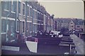
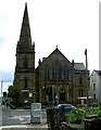
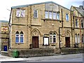
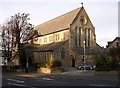
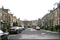
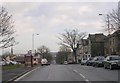
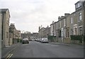
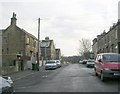
Photos of BD7 2BB
Area Information
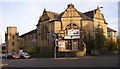
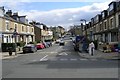
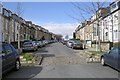
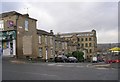
Living in BD7 2BB means inhabiting a densely populated residential cluster nestled within the City of Bradford, West Yorkshire. This small postcode area covers just 7,482 square metres, yet it houses 1,987 people, resulting in a population density of 265,566 people per square kilometre. The area’s compact size and high density reflect its role as a historic township that has evolved into a tightly knit urban community. BD7 2BB lies within the Great Horton conservation area, preserving 17th- to 19th-century buildings alongside 19th-century workers’ housing. Its proximity to Bradford city centre—just 2.5 miles away—offers easy access to urban amenities while retaining a distinct local character. Residents benefit from nearby schools, retail hubs, and rail links, creating a balance of convenience and historical resonance. The area’s demographic profile, with a median age of 47 and a majority of adults aged 30–64, suggests a stable, mature community. For those seeking a compact, connected postcode with a mix of heritage and modernity, BD7 2BB offers a unique blend of urban living and preserved history.
- Area Type
- Postcode
- Area Size
- 7482 m²
- Population
- Not available
- Population Density
- Not available
The property market in BD7 2BB is characterised by a 60% home ownership rate, with houses forming the majority of accommodation types. This suggests a mix of owner-occupied homes and rental properties, though the exact proportion of rentals is not specified. The small area size—just 7,482 square metres—means housing stock is limited, likely concentrated in the historic conservation area. Many properties are 17th- to 19th-century buildings, including workers’ housing and listed structures, which may influence property values and desirability. Buyers should consider the area’s compact nature, which could limit availability for new builds. The presence of a conservation area also means stricter planning regulations, potentially affecting renovations or extensions. For those seeking a historic home with a connection to Bradford’s industrial past, BD7 2BB offers a niche market, though its small size may require looking beyond immediate surroundings for additional options.
House Prices in BD7 2BB
Showing 16 properties
| Address | Type | Beds | Baths | Last Sale Price | Last Sale Date | |
|---|---|---|---|---|---|---|
| 264 Ingleby Road, Bradford, BD7 2BB | Semi-detached | 3 | 1 | £76,000 | Jun 2023 | |
| 240 Ingleby Road, Bradford, BD7 2BB | house | - | - | £80,000 | Nov 2022 | |
| 244 Ingleby Road, Bradford, BD7 2BB | Terraced | 2 | 1 | £70,000 | Dec 2017 | |
| 254 Ingleby Road, Bradford, BD7 2BB | Terraced | 3 | 1 | £100,000 | Mar 2017 | |
| 246 Ingleby Road, Bradford, BD7 2BB | house | 3 | - | £110,000 | Jan 2014 | |
| 242 Ingleby Road, Bradford, BD7 2BB | house | 3 | 1 | £102,000 | Feb 2013 | |
| 256 Ingleby Road, Bradford, BD7 2BB | house | 3 | - | £115,000 | Sep 2011 | |
| 258 Ingleby Road, Bradford, BD7 2BB | house | 3 | - | £115,050 | Aug 2009 | |
| 268 Ingleby Road, Bradford, BD7 2BB | house | - | - | £120,000 | Mar 2007 | |
| 262 Ingleby Road, Bradford, BD7 2BB | Terraced | - | - | £64,000 | Nov 2005 |
Energy Efficiency in BD7 2BB
Life in BD7 2BB is shaped by its compact size and proximity to essential amenities. Nearby retail options include Asda Bradford, Morrisons Scholemoor, and Tesco Bradford, providing access to grocery and daily shopping needs. The area’s rail network, with five stations, ensures easy travel for work, leisure, or commuting. While the data does not mention parks or leisure facilities directly, the Great Horton Conservation Area includes historic buildings and Horton Park, a public park opened in 1878. This suggests opportunities for outdoor recreation, though specifics are not detailed. The presence of 74 listed buildings and 19th-century workers’ housing adds to the area’s unique character. For residents, the combination of retail, rail, and historical sites creates a lifestyle that balances convenience with a sense of local heritage.
Amenities
Schools
Residents of BD7 2BB have access to a range of schools, including Lidget Green Primary School, Lidget Green Middle School, and Dixons Kings Academy. Both Lidget Green Primary and Middle School are primary institutions, though the latter’s name may suggest a transition to secondary education. Dixons Kings Academy is an academy with an Ofsted rating of outstanding, indicating high educational standards. The mix of primary and academy schools provides families with options for both early education and secondary schooling. The proximity of these institutions—many within walking distance—enhances the area’s appeal for families. However, the repetition of Lidget Green Primary School in the data may reflect a duplication error. Overall, the school network supports a range of educational needs, from early years to secondary education, though parents should verify specific catchment areas and admission policies.
| Rank | School | Type | Entry gender | Ages |
|---|
Explore more schools in this area
Go to Schools tabDemographics
The population of BD7 2BB is 1,987, with a median age of 47, indicating a community skewed towards middle-aged and older residents. The most common age range is adults aged 30–64, suggesting a stable demographic with established households. Home ownership in the area stands at 60%, with houses being the predominant accommodation type. This implies a mix of owner-occupied properties and rental units, though the exact proportion of rentals is not specified. The predominant ethnic group is Asian_total, reflecting a culturally distinct community. While no explicit data on deprivation is provided, the high population density and historical industrial roots suggest a mix of socioeconomic backgrounds. The presence of 17th- to 19th-century buildings in the conservation area indicates long-term residency, with many properties likely passed down through generations. This demographic profile aligns with a mature, settled population seeking stability in a historically significant urban setting.
Household Size
Accommodation Type
Tenure
Ethnic Group
Religion
Household Composition
Age
Household Deprivation
NS-SEC
Explore more demographic insights in this area
Go to Demographics tabPlanning
Planning Constraints
- Flood RiskPremium
- Ramsar Wetland SitesPremium
- Area of Outstanding Natural BeautyPremium
- Protected Nature ReservePremium
- Protected WoodlandPremium